Current Radar
Tonight – Steamy
HRRR was wrong today; afternoon rain/storms didn’t form here (they were southeast of us).

Summer makes liars of weather models.
When the sun sets, any rain chance will set with it.

Current Radar
HRRR was wrong today; afternoon rain/storms didn’t form here (they were southeast of us).
Summer makes liars of weather models.
When the sun sets, any rain chance will set with it.
Current Radar

It’s hot, it’s humid, so much so, everyone unfavorite game of thunderstorm uncertainty is being played. When, where, how bad? Yeah, we don’t know. It’s like guessing where exactly in an about-to-boil big pot the first water bubble will surface.
Current Radar
For tonight’s Fourth of July 2.0, the weather will be much better. Those Fine Americans who braved the rain in Nashville for fireworks last night had to contend with low clouds which made the show look like a Grateful Dead concert. Clouds were forming at 356 meters, which is under 1,200 feet. Not good fireworks weather.
Current Radar
630 PM Update: A Flash Flood Warning is in effect for Williamson County. If you’re in the green box, my advice is to stay home.
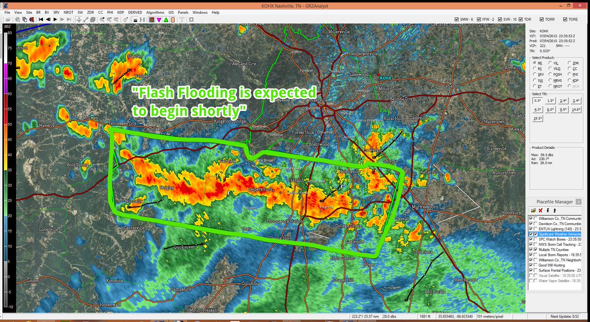
The stationary front remains north of us. Rain and storms have been firing off it as it feeds off the humid air mass overhead.
Current Radar
A stationary front has set up just north of us. Rain and storms are firing off it as it feeds off the humid airmass overhead:
Expect scattered showers — some heavy at times — to move east this afternoon.
Current Radar

The main rain band has set up well south of us:
I drew white squiggly lines on the above image to show little ripples/waves in the clouds, extending all the way back to Oklahoma. A few small showers were forming along that route this morning.
Current Radar
Showers and storms over Kentucky tonight have weakened. We will remain comfortably south of all that, with only our new, home grown, light showers to contend with beginning sometime around midnight (maybe a bit before then for Williamson County).
Current Radar
The I-24 Storms are coming from the NW. See the above radar and follow us on Twitter @NashSevereWx for more info. These have strong, and maybe severe, potential.
The Storm Prediction Center still has our probability of a hail or a damaging wind event within 25 miles of us at 5%. We are excluded from their tornado outlook.
Current Radar
Showers and maybe a few storms may swing through this afternoon. The HRRR model sure thinks so:

I chose this wide view because it shows this week’s “source” of rain/storm activity: the northwest.
Current Radar

Reopening Monday, the I-24 Storm Corridor, where rain and storms get here by moving from NW-to-SE.

The first of a series of shortwaves this week is already ongoing as I write this in Missouri.