Tonight & The Weekend

Current Observations and Radar (trying something new)

Tonight – Don’t Cancel Your Plans

We had a couple of no-quite-severe storms, including small hail in N Davidson Co and this wet microburst:

A look at the HRRR for the rest of tonight looks pretty grim for outdoor stuff: read more

The Weekend

Current Observations and Radar (trying something new)

Friday – Humidity & Rain Chances Return – High 89°

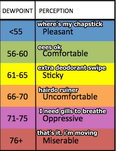
Humidity is back!

This summer, rain has usually come from I-24 in Kentucky, moving SE towards us.

Today, that pattern reverses.

As I write this, a few renegade rain showers are working their way NW from the Chattanooga area.The HRRR model – although possibly exaggerating this feature – shows rain taking I-24 and advancing closer through all day: read more

Hopefully This Forecast Will Be Less Terrible

Current Radar

Tonight –  Can’t Rule Out, But Not Expecting, Rain 

Although we expressed uncertainty (here and on Twitter), I grade today’s “some rain” forecast like this:

I can point to the storms that formed 30 miles that way, or offer some explanation for the sunshine and attempt to sound smart. But really, who cares. read more

Today: Not Great. Rest of the Week: Great.

Current Radar

Today –  Humid, Off & On Rain, Maybe a Storm – High: 90°

A lot of rain is piling up to our west. It’s being pushed by a weak cold front, which will arrive tonight.

Here’s what the HRRR thinks the radar will look like through 9 PM:

read more

Some Rain Monday, Then We Cool Off

Current Radar

Monday –  Some Rain, Maybe a Storm – High: 91°

A cold front is coming, which means off and on rain is expected during the day. Blanketing clouds will keep temps from soaring to 93° (where we were Sunday).

We aren’t exactly sure when the rain will start. The NAM4 model thinks we’ll see it around 10 AM: read more

What Is Going On Here?

Current Radar

Experimental Radar

(Poor Mr. Belding)

Tonight – We Don’t Think It’ll Rain

The slim chance of rain did not materialize.  We did see showers at the TN/AL border, but nothing bugging us.

We can’t completely rule out a shower from sprouting, but we don’t think it’ll rain tonight. read more

Watching for Shortwaves & the Return of Rain

Current Radar

Experimental Radar

Today – More Humidity – High: 94°

Humidity was low this weekend thanks to dewpoints in the 50°s and low 60°s. This ends today.

The dewpoint will move into the mid 60°s, a decent crank-up of humidity. read more

Getting Hotter

Current Radar

Pleasant Tonight

We hit 90° today, but the dewpoint never made it out of the 50°s.

Monday – Warming Up – High: 94°

The winds will shift from north to south overnight Sunday into Monday morning. So, hotter.

Tuesday – Still Hot; Rising Humidity – High: 94°

The dew point will climb into the upper 60°s. read more

Tread Lightly Tuesday

Current Radar

Tue 95°, Wed 94° Oppressive Humidity, Small Rain Chances

Today dewpoints in the low 70°s will hang around Tuesday and Wednesday.

It’ll remain awful out there. The heat index (“feels like”) temp will range between 100° and 105° Tuesday and Wednesday. read more

Oppressive Humidity Arrives Tonight

Current Radar

Oppressive Humidity Arrives Tonight

The rain moving down I-24 this afternoon should be completely gone by sundown.

By 10 PM tonight, the dewpoint will rise to 73°.

That’s oppressive humidity.

Super Humid Monday High: 94°

The heat index will hit the triple digits by noon. read more