Search Results for:
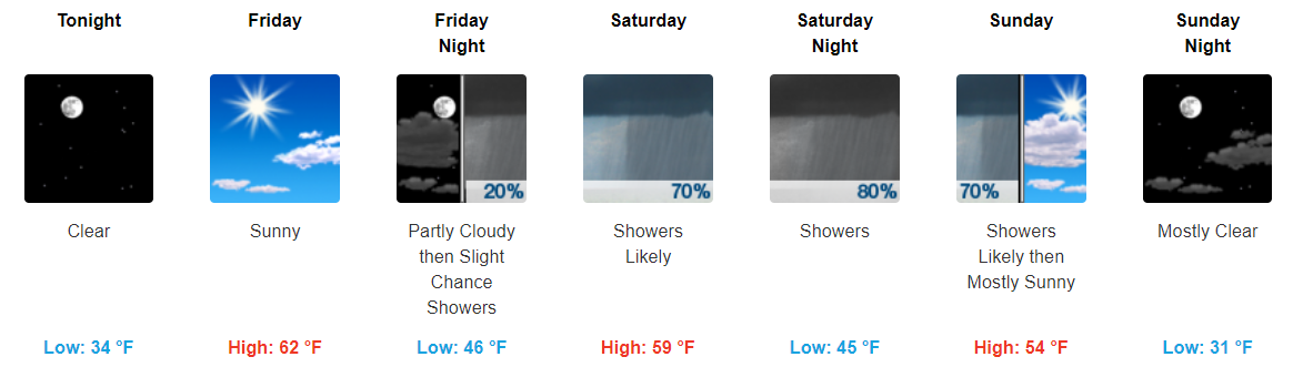
Sunshine For Now, Showers on Saturday

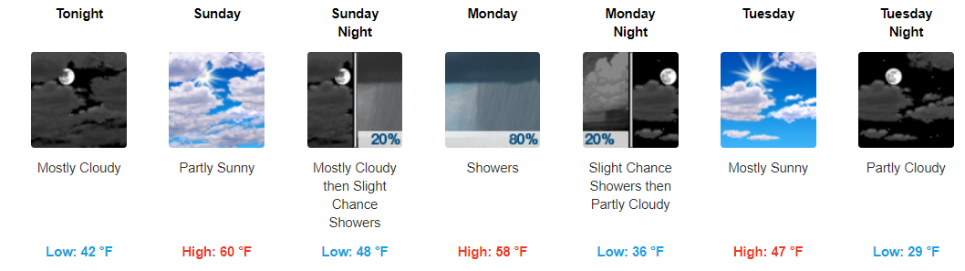
Average Temps for Now, Slightly Above Average Temps by the End of the Week
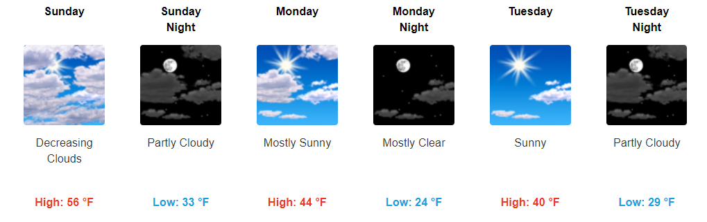
Temps Continuing to Rise, Some Sunshine & Some Clouds This Weekend
Warm and Partly Sunny Skies
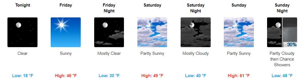
Happy weekend! This weekend looks fantastic for any outdoor plans you may have. Highs today will top off in the low-50s before reaching into the low-60s on Sunday. Enjoy the amazing weather!

Heading downtown tonight for the Preds game? Temps look to be in the upper-40s at puck drop before dropping into the mid-40s by the end of the night. Go Preds!
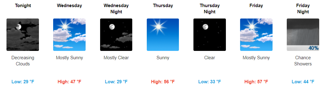
Temps Warming, Sunshine for Now
Gradual Warming Into the Weekend
After the bitter cold temperatures we’ve had, the end is finally in sight. Today and tonight will still be on the chillier side with highs in the upper-30s and overnight lows in the teens.
Starting tomorrow, temps will climb into the 40s before reaching the low-60s (yes 60s!) on Sunday.
Snow Totals, Wind Chill Advisory (& Black Ice) Tonight, Very Cold Tomorrow
Winter Weather is Here; Taking a Peek at Monday
Note the time this was posted. Check Twitter @NashSevereWx for updates and any changes.
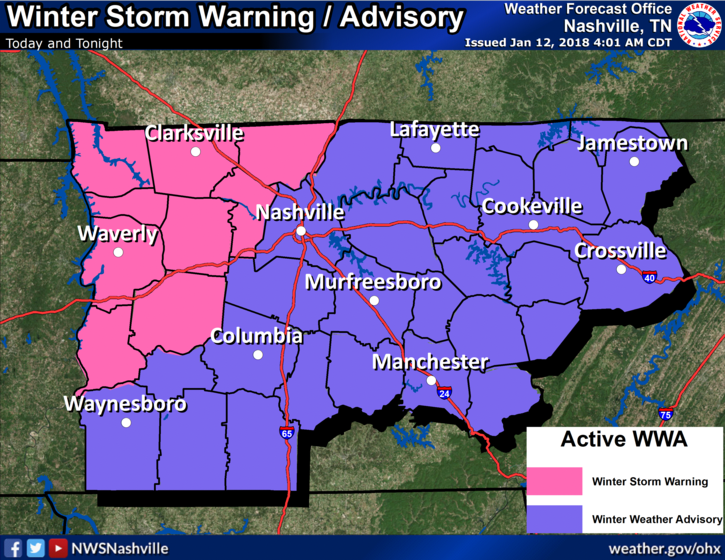
Winter Weather Advisory – NOW Through Midnight Tonight
Current Radar Loop 3:00 PM to 3:40 PM
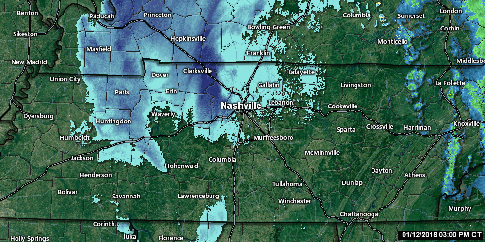
Snow showers have already arrived to our northwest and continue to move towards us. We are still looking at 1″ to 2″ of total accumulation for those north of I-40 and less than an 1″ expected for those south of I-40.
Here It Comes. Winter Weather Beginning. What To Expect.
Note the time this was posted. Check Twitter @NashSevereWx for updates and any changes.
Winter Weather Advisory – 8 AM This Morning Through Midnight Tonight
What
- Ice accumulation up to a 0.10 of an inch. This will occur in the AM and early afternoon primarily.
- Snow and sleet accumulation around an 1″. This will occur during the afternoon into the early evening.
Note: models are showing different things. Some show more ice and/or snow, while others do not. These are just very rough estimates.
When and Current Model Trends
Already this morning we have see plenty of rainfall. The freezing line is currently knocking on our doorstep, which will turn our rain showers into a wintry mix very shortly. Expect for the wintry mix to arrive in the next hour or two.
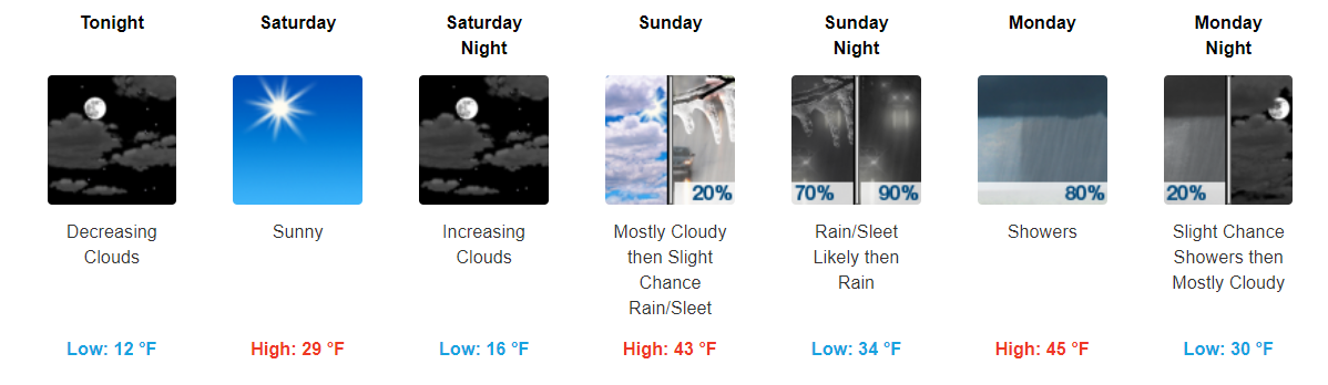
Chilly Chilly Temps Continue. Somewhat “Warmer” Next Week
It’s Cold!
Frigid temps continue today and tomorrow. Temps will not reach to above freezing until Sunday. Stay bundled up over the next 48 hours folks.
Somewhat Warmer, Rain/Sleet Chances Sunday Night
Sunday through the beginning of next week temps look to rebound into the low-40s. We will finally get out of the never-ending freezing weather for now.
Still Cold, Slight “Warm-Up” Coming
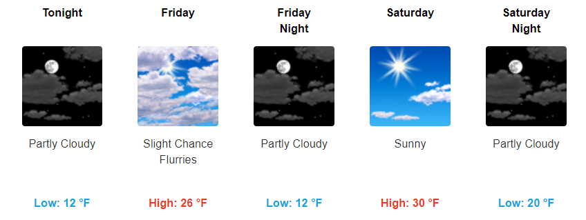
Frigid Temps Return For Now
Yesterday, we had the pleasure of seeing some temps above freezing for a little while. Unfortunately, temps have fallen back below freezing and look to stay there through Saturday.

With temps this cold, it should at least snow, right?! Again, unfortunately no. We do have the possibility of a few flurries squeezing out Friday, but other than that sunny skies will come along with our frigid temps.