Current Radar
Experimental Radar

Today – More Humidity – High: 94°
Humidity was low this weekend thanks to dewpoints in the 50°s and low 60°s. This ends today.

The dewpoint will move into the mid 60°s, a decent crank-up of humidity.

Current Radar
Experimental Radar
Humidity was low this weekend thanks to dewpoints in the 50°s and low 60°s. This ends today.
The dewpoint will move into the mid 60°s, a decent crank-up of humidity.
Current Radar
We hit 90° today, but the dewpoint never made it out of the 50°s.

The winds will shift from north to south overnight Sunday into Monday morning. So, hotter.

The dew point will climb into the upper 60°s.
Current Radar
Today – Less Humidity High: 92°
It will be another dry day for us!
There is an Air Quality Alert for us today through 7:00 PM.

Ground level ozone concentrations may approach or exceed unhealthy standards. Mainly for children, adults, and people with respiratory disease like asthma should limit prolonged outdoor exertion.
Current Radar
High pressure will continue to dominate and no showers are in the forecast for Sunday!
Winds will begin to shift out of the south. We will begin to warm up into the mid 90s.
Dew point will be in the upper 50s. It’s looking like a good hair day!
Current Radar
We’ve had some pretty great weather today, considering it’s the last day of July. Bye, July!

Dew point temperatures have been in the 50°s this afternoon. So, even though temps have read around 90°, it hasn’t felt hotter than that.
Current Radar
“Cooler,” drier conditions will remain as we head into the evening hours.
Rain will continue to stay far, far away:
It should be a really nice night to get outdoors.

Lows overnight will fall to the mid to upper 60°s!
Current Radar
The Heat Advisory will remain in effect until 7 PM:
Warm & humid conditions will follow us into the evening hours, and we’ll stay dry…
…until later tonight when storms ahead of a cold front approach:
Current Radar
Another cluster of non-severe thunderstorms looks to be making its way south from Kentucky. If the storms hold together, we may see them within an hour or so.
As things keep cooling off this evening, shower/storm activity should begin to diminish, especially after the sun sets (7:55 PM):
Current Radar
Today dewpoints in the low 70°s will hang around Tuesday and Wednesday.
It’ll remain awful out there. The heat index (“feels like”) temp will range between 100° and 105° Tuesday and Wednesday.
Current Radar
The rain moving down I-24 this afternoon should be completely gone by sundown.
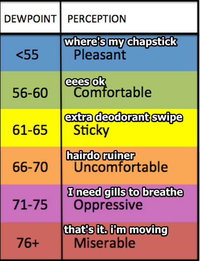
By 10 PM tonight, the dewpoint will rise to 73°.
That’s oppressive humidity.

The heat index will hit the triple digits by noon.
You must be logged in to post a comment.