Well, it snowed. Which has left some roads a mess, if you have to go out today, take it nice and easy. Also, the kiddos are probably going to want to play in the snow, however, this is not ideal playing-in-the-snow weather. In fact, it may be tongue stuck to flagpole cold. I wouldn’t try and see for yourself though.read more
This afternoon, Davidson Co. was upgraded to a Winter Storm Warning. Snowfall totals of 1-2″ are expected, with a few pockets of 3-4″ possible. Impacts remain the same as mentioned below in the rest of the blog.read more
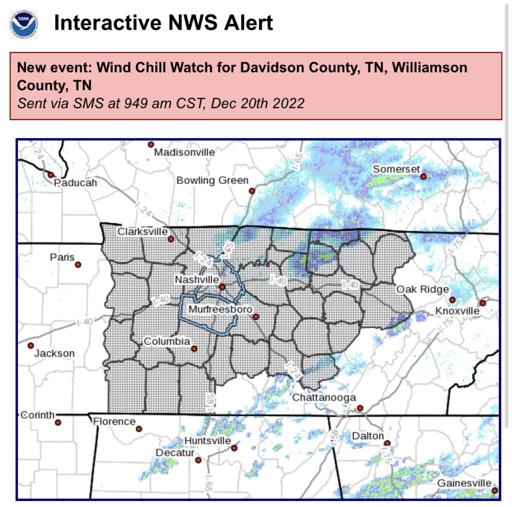
NWS Nashville issued a Winter Weather Advisory for both of our counties from 6pm Thursday – 6am Friday.
They also extended our Wind Chill Warning, now starting at 10pm Thursday thru noon Friday, accounting for the expected earlier arrival of the cold front.read more
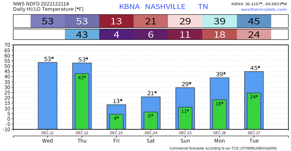
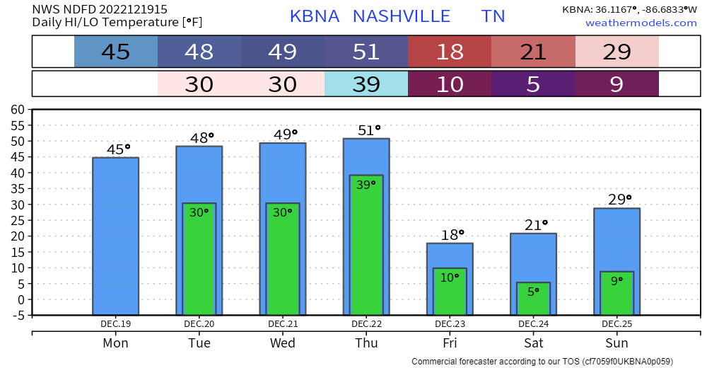
Today, Wednesday, and the majority of Thursday will be not too bad as high temps try to reach 50°. If you have something to do outside, I’d probably get it done now.
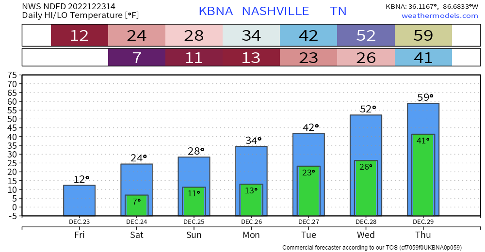
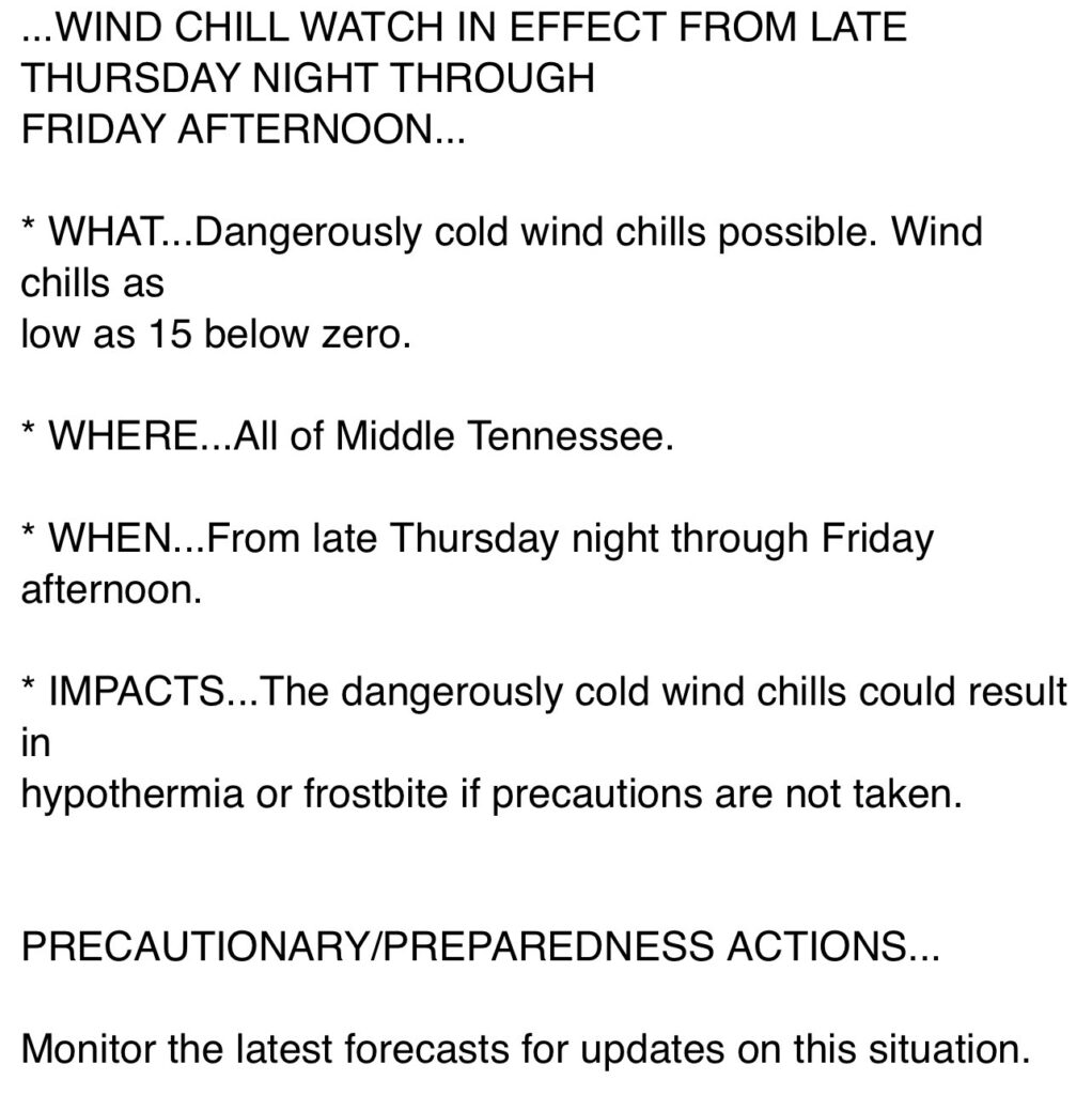
Thursday it should start raining sometime midday/afternoon. Then the arctic air arrives around 9p, give or take a few hours. Temperatures will plummet into the single digits overnight. High temperatures will struggle to make it into the teens on Friday, while wind chill values will not make it above zero throughout the day Friday and into midday Christmas Eve. A Wind Chill Advisory was issued for wind chill values of ten-fifteen degrees below zero, due to guests as high as 35-40mph. Temperatures will stay below freezing for “`~84 hours Thursday night into midday Monday. Anyone planning on going to the Titans game X-mas Eve needs to plan to really bundle up, as feel like temperatures will be in the single digits the entire game.
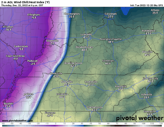
GFS Wind Chill: 6pm Thursday – 12am Saturday
Especially if you are heading out of town, but even if you aren’t, the time to prepare is now. read more
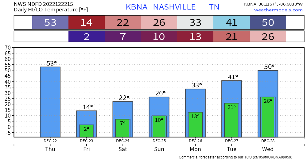
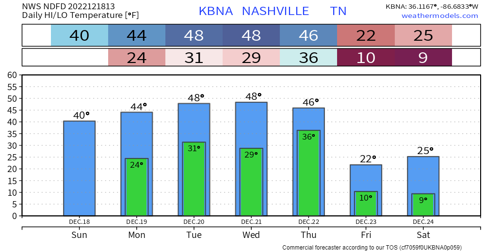
Today through the majority of Thursday will be “nice” as temps reach the upper 40’s, maybe even low 50’s. Dry. Not too shabby.
Thursday night, temperatures are expected to plummet into the single digits/low teens. Temperatures will likely stay below freezing until midday Monday. This will leave us with dangerous conditions. It’s time to start preparing now, especially if you are heading out of town.read more
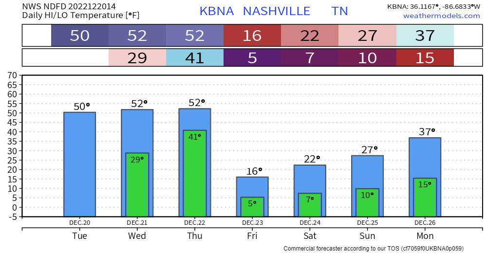
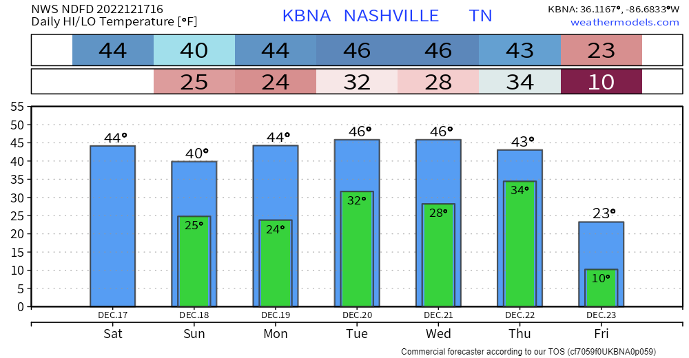
The days leading up to Thursday won’t be the best, but compared to the end of the week, it’ll feel like summer. High temps will actually slowly climb to the upper 40’s by Tuesday, with lows touching the freezing mark most nights.read more
The days leading up to Thursday and Friday won’t be the nicest temperature wise, but compared to what the temperatures will be, you’ll be wishing we were in the 40’s…
Friday’s temps…yikes. Temps like that will linger around through Christmas weekend.read more
Temperatures will be fairly consistent for the next five days or so. Highs in the 40’s, lows in the mid to upper 20’s. That’s cold, but pretty average for this time of the year. Not really any meaningful chances for any precipitation, the GFS shows some showers on Monday, but other models think it’ll be too dry.read more
So it’s colder today. It will stay that way for a while. Are we done with 60’s? No, probably not. Are we done with them for the next few weeks?
That’s right coach. If you like the cold, these next few weeks are for you. Clear, dry, chilly, sunny days are forecasted through at least Tuesday of next week. read more
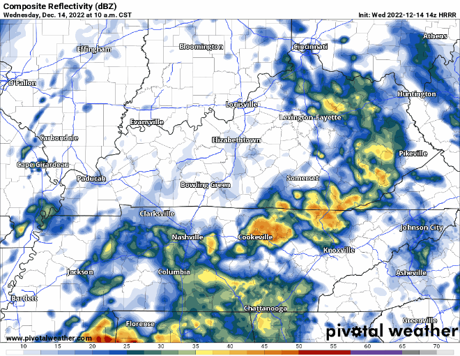
It has been a wet, damp, moist, whatever word you want to use to describe this morning, and it is only going to continue throughout the day.
The HRRR model (above) shows on/off rain really all day, before the rain finally pushes east of us at around 11pm, give or take an hour or so. read more
Subscribe to Blog via Email
Privacy & Cookies: This site uses cookies. By continuing to use this website, you agree to their use.
To find out more, including how to control cookies, see here:
Privacy Policy


You must be logged in to post a comment.