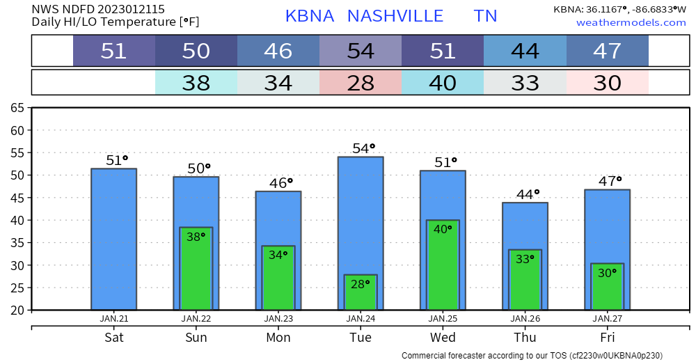
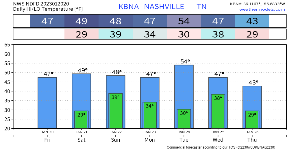
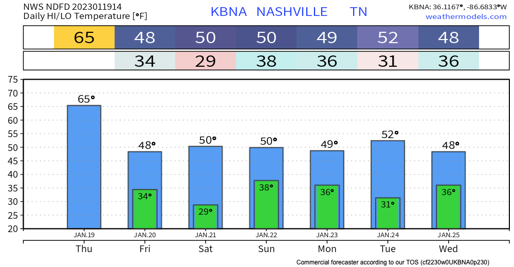
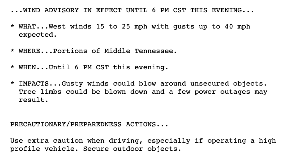
Throughout today, we’re expecting to see some scattered showers. Some of these individual clouds could drop some heavy rain and wind. No need to cancel daytime or dinner plans, but carry an umbrella in case the rain scatters on you.
Category: Featured Blog
Cool and Dry (For Now); Some Rain This Weekend
The cold front associated with yesterdays storms just passed through our area. This leaves us a little cooler for the rest of the week. Temps cool to the mid 60s by the holiday weekend.
We’re taking a short break from the rain. Today and most of tomorrow will be dry. Next chance for rain comes in Friday evening. GFS and Euro models scatter showers around town Friday evening after dinner time and continue through the overnight hours. The HRRR has a higher resolution take and shows the rain getting here after midnight Friday night:
Severe Weather Risk Tonight
Another Stormy Wednesday, Severe Storms Possible
TONIGHT – OVERNIGHT – WEDS MORNING
- Scattered rain will be off and on late Tuesday night through Wednesday morning. Lightning and gusty winds possible. Not worried about tornadoes and not worried about severe straight line winds. Here’s the HRRR model through noon Weds:

- We’re watching for flood potential for this rain tonight – Wednesday morning. That concern is mostly W and NW of us. Yes we got a lot of rain in the last 24 hours. It wouldn’t take much more to push creeks and streams back up. But this doesn’t look like enough rain to raise overnight/morning flood concerns. We’ll see. There’s a Flash Flood Watch just to our west and northwest.

SEVERE SYSTEM DEVELOPS OUT WEST WEDNESDAY
- Quiet Wednesday afternoon.
- West of us, during the day Wednesday, a significant severe weather event will be ongoing.

SEVERE SYSTEM GETS HERE . . . BUT HOW BAD WILL IT BE?
- That significant severe event will congeal into one or maybe two lines. It will move east into Davidson and Williamson Counties. ETA could be as early as 6 PM. It could be as late as just after midnight Wednesday night.
- The initial line should carry the primary severe storm threat because it would arrive with the highest CAPEs and shear.
- So if there are two lines, the first would arrive here late afternoon/early evening and carry the higher straight line wind, hail, and tornado threat. If a second line comes in behind it closer to midnight it would be primarily for damaging straight line winds (tornado less likely with the second line because the first line will have used up the main source of storm fuel).
- Or, it’s possible there will just be one big ole line. Here’s what the HRRR shows, just one line, with a 9-10 PM arrival.

- The initial (only?) line will deliver probabilities for damaging straight line winds (30% probability within 25 miles of you), large hail (5% probability within 25 miles of you), and tornadoes (5% probability within 25 miles of you). Flooding is also possible but the line should move quickly enough to reduce the probability of a significant flash flooding event.
- The above run of the HRRR shows the line weakening — perhaps weakening significantly — as it arrives here 9-10 PM. That would be outstanding if it happens. But if the line arrives earlier (closer to 6-7 PM), it should be tapping more storm fuel and be stronger. Models have been going back and forth on an early evening vs late evening event. Either could happen.
- Know today where your safe space will be tomorrow night. Do not leave yourself uninformed, vulnerable, and far from shelter should a warning be issued. Questions? This link may help.
- This forecast may change, especially the timing, so check our Twitter and other reliable sources of information for updated/new information.

Quick References:
Weather changes constantly.
Follow @NashSevereWx on Twitter for any changes to this forecast.
Live coverage during tornado and severe thunderstorm warnings:
Look good.
Support the mission.
Severe Storms Wednesday Night
Active Weather This Week
A wet, weather-filled week is ahead of us. Two rounds of potential severe weather are coming our way this week. Starting off with today:
Storms Later Today
Showers persist today with a small break in rain this afternoon for some of us. HRRR model below has strong storms coming into our area after sunset. These continue into the overnight hours and should be out of our area by Tuesday morning.
Still Watching Wednesday
Sunday will be warm and sunny. A little breezy, too. Perfect day to get outside, enjoy it because rain is coming.
Monday will bring on and off rain showers and storms. Classic spring weather. Expect more “off” than “on” rain. Nothing severe is expected. There could be some lightning and thunder, but that’s it. ETA looks to be just before lunchtime. See HRRR below:
Cool Today, Warm Sunday, Watching Wednesday
Chilly and Rainy Friday
We will continue to see scattered showers for the rest of the day. Some sleet and graupel has fallen in some part.

Some rumbles of thunder are possible with a few of these storms, but nothing to be concerned about. As temps drop, some of these showers could be a little winter-y, but this is mostly to our East
Colder Air Settling In, More Rain Tomorrow
Temps down a good bit from yesterday. Mostly quiet today except for maybe an inconsequential PM shower or two.

Chances for rain go up tomorrow. Scattered showers throughout the day. No strong/severe storms expected… Can’t rule out the occasional rumble of thunder. Not much accumulation expected with this system. No flooding concerns here.