Current Official Hourly Observation:

5:30 PM Update
We still may see some snow tonight. The cold front as arrived, and now “back edge” precip has developed, which may be changing to snow.

Current Official Hourly Observation:
5:30 PM Update
We still may see some snow tonight. The cold front as arrived, and now “back edge” precip has developed, which may be changing to snow.
Current Official Hourly Observation:
9:38 PM NWS Forecast Discussion
9:30 PM Update
The models continue to do some
GFS only gives us a dusting through Monday at 6 AM:
Current Official Hourly Observation:
Today – Sunny & Breezy – Afternoon High 46
9a 29 . 12p 40 . 3p 45 . 6p 42 . 9p 40
This is the calm before the storm.

Consider today your prep day:
Current Official Hourly Observation:
Tonight – Clear & Cold – Midnight Temp 23
Wind chills will drop into the teens tonight. Those will seem warm compared to what’s up ahead…
Latest Official Hourly Observation:
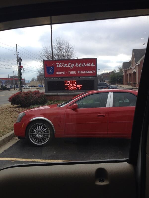
@KeelyHall tweeted this photo of a supercold spot in Brentwood today:
Tonight – Light Snow & BRRR – Midnight Temp 22
Attention snow lovers and non-lovers alike. A special weather statement has been issued by our NWS.
Latest Official Hourly Observation:
@KeelyHall tweeted this photo of a supercold spot in Brentwood today:
Tonight – Light Snow & BRRR – Midnight Temp 22
Attention snow lovers and non-lovers alike. A special weather statement has been issued by our NWS.
Latest Official Hourly Observation:
Tonight – Chilly Rain – Midnight Temp 41
HAPPY NEW YEAR EVERYONE!
Rain is starting to move into Middle TN tonight. It’s too warm for it to fall as snow.
Latest Official Hourly Observation:
Tonight – Cold & Clear
6p 38 . 9p 33 . 12a 31 . 3a 29
Cold, but not too bad.

New Year’s Day – Mostly Sunny, Warmer, Rain Very Late – Morning Low 24 / Afternoon High 51
Latest Official Hourly Observation:
New Year’s Eve – Sunny – Morning Low 23 / Afternoon High 45
6a 24 . 9a 31 . 12p 40 . 3p 44 . 6p 38 . 9p 33 . 12a 31
New Year’s Eve day will be sunny and warmer.
Latest Official Hourly Observation:
Today – Rain Ends; Mostly Cloudy – Afternoon High 50 / Midnight Temp 34
9a 43 . 12p 48 . 3p 49 . 6p 42 . 9p 37
Yesterday’s rain is gone.
You must be logged in to post a comment.