Warm and Humid Through Thursday, Rain Chances Resume Thursday

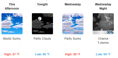
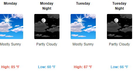
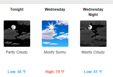
This Afternoon Through Wednesday

High pressure to our east means south winds bringing return-to-summer temperatures.

Thursday and Friday

A frontal boundary sets up bringing daily chances for showers and maybe an isolated thunderstorm beginning late Thursday. Severe weather is not expected at this time, but a few strong storms are possible in spots. read more

Cooler Today, Warmer Monday and Tuesday with Unsettled/Rainy-Stormy Weather By The End of the Week

Today and Tonight

Partly sunny skies this morning will gradually clear out making for a beautiful and sunny, but cooler afternoon with highs right around 70. Clear and comfortable conditions tonight with a low near 54.

Monday and Tuesday

Warm and dry with highs in the mid 80s and lows in the 60s. Great time to spend outside! read more

Chance for Showers Wednesday, Rain for NFL Draft Night, Dry and Pleasant for Marathon Saturday

Tonight

After a pleasant and warm afternoon, tonight will remain on the mild side with a low near 58.

Wednesday and Wednesday Night

Clouds will be increasing as a frontal boundary slowly drops in from the north. This may bring an isolated afternoon shower to the region, although it remains uncertain as the models have been showing two different pictures. The latest NAM3 says we don’t get anything: read more

Heavy Rain Tonight; Cooler and Rainy Friday with A Gradual Weekend Warm-Up. Beautiful Easter Sunday!

Tonight

Showers and thunderstorms will move into our region over the next several hours. The main threat is locally heavy rainfall, which the National Weather Service highlights in their afternoon discussion:

Some strong to maybe a couple of severe thunderstorms possible, but in analysis of model sounding profiles, this looks more and more like mainly a rain making event with some heavy downpours this evening causing local ponding of water on area roadways and possible minor flooding of flood prone areas. read more

Stormy, Rainy Thursday Night: Strong/Severe Thunderstorms Possible

Pretty Great Thru Wednesday Night

Pleasant conditions will persist into Wednesday as an area of high pressure continues to bring sunny and dry weather. Temperatures will remain above normal with lows tonight in the mid 50°s and highs tomorrow right around 80°. read more

Wet and Unsettled Weekend Ahead

This Afternoon and Tonight

A beautiful, sunny, warm, and breezy afternoon will give way to increasing clouds with showers and thunderstorms late tonight into tomorrow morning as a cold front swings through.  Out ahead of, and behind this front, we will continue to see windy conditions, which is why the National Weather Service has placed us under a Wind Advisory until 1 am Friday. NWS: read more

Sunny and Beautiful through Mid Week; Thunderstorms Possible Late Thursday

This Afternoon into Tonight

It is an absolutely beautiful afternoon out there today! As you can see in the map below, most places in our region are in the mid and upper 70s with abundant sunshine. These conditions will continue into the evening with temperatures topping out right around 80 degrees. Skies will remain mainly clear overnight as an area of high pressure moves into the region bringing light winds and near normal temperatures with lows near 50 degrees. read more

Flood-Producing Rains Possible, Severe Weather Saturday

[Please read the entire blog, including the editor’s comments at the end, regarding the flooding threat. First, intern “applican” Jon lays out the next few days for us:]

Summary

After a brief drying period, rain has arrived and will continue through Saturday night. A flash flood watch is in effect for the entire Middle Tennessee region including Davidson and Williamson counties from tonight until Saturday evening as the potential exists for an additional 2- 4 inches of rain, with locally higher amounts where storms tend to “train” or sit over an area dumping rain. The concern for flooding is big. Another issue that we may have to deal with is a potential severe storms Saturday afternoon. More on this later. A cold front sweeping through Sunday will bring a much needed end to the rain with temperatures remaining right around normal or just a couple degrees above. read more

After a Mild and Pleasant Day, A Wet Weekend Is In Store For The Area

TODAY

It is a very pleasant and mild afternoon out there today without temperatures topping out in the low 60’s. These conditions will not last however, as an approaching cold front will bring temperatures back to near normal for this time of the year, along with renewed chances for rain. I have a map below which shows the location of our cold front marked with the blue triangles as of 12 PM Central Standard time. Out ahead of this front, we are in a warm sector with a mild and breezy southwesterly flow. As this front approaches and moves through tonight we will see a drop in temperatures and even a slight chance of a shower. read more