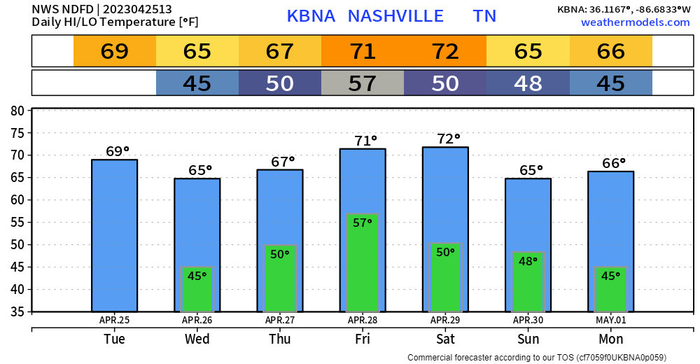
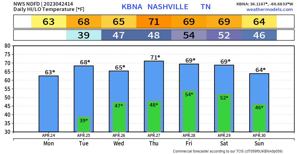
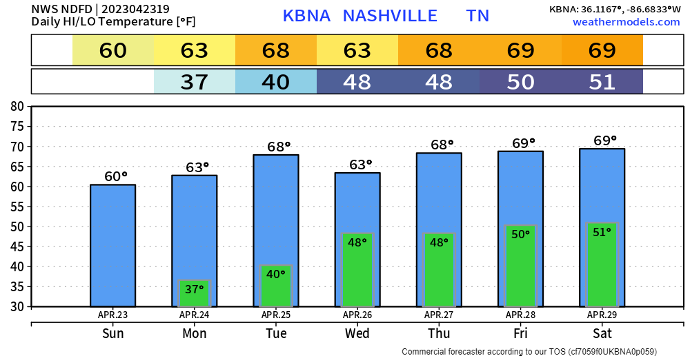
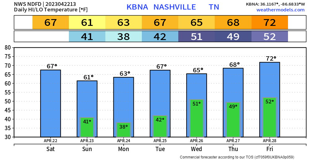
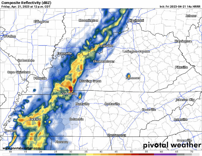
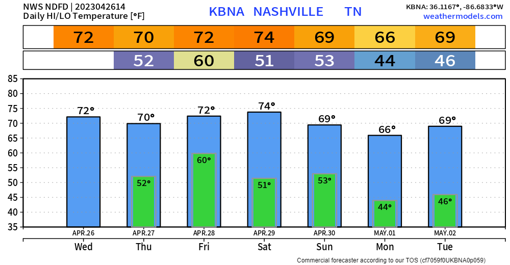
Rain is mostly confined to our southeast, but some stray showers aren’t wanting to leave. HRRR model (below) continues to show chances of these stray showers hanging around all day.
As of 11am, rain is mostly confined to the SE corner of WillCo., and will slowly continue to push out, clouds will stick around for the day though. You can check the radar anytime here: Radar – Nashville Severe Weatherread more
The severe threat is over. The Severe Thunderstorm Watch originally set to expire at 9pm has been canceled. You can tweet any damage you might’ve had (hopefully not) with #tspotter.
Our focus now moves to an overnight threat for heavy rain. A Flood Watch for both of our counties will begin at 11pm tonight and go thru 1pm Thursday.read more
We’re still looking at a possibility of severe weather today, specifically this afternoon and evening. It’ll be important to be weather aware today and have multiple ways to receive information. Let’s dive right in. read more
There will be a day to when I do not have to include something along the lines of “possible severe storms” in the title. But, today is not that day, so let’s talk about it.
Record high for today is 87° set in 1934, our current forecast high is 86°, it’ll be close. No rain expected today.read more
Some light showers continue to move through this morning. These should move out around lunch time leaving us with a dry rest of the day. High today is supposedly 68°, not sure we make it there with this cloud cover. read more
For the most part, generally a nice week ahead except for a few flaws.
Majority of Monday will be dry, a shower or two may pass through at some point during the day, but it should be quick and of little consequence. read more
Wind Advisory today until 7pm with gusts up to 45mph are possible. Frost possible in many areas Sunday morning, so cover up loved plants.
Another severe weather round is possible Tuesday.
The Storm Prediction Center has maintained our 15% chance of severe weather within 25 miles for Tuesday. Details are still hazy and trying to say an ETA is tough. But a superrr rough estimate would be Tuesday PM – Wednesday AM. All modes of severe weather look possible, as CAPE (storm fuel) and wind energy look plentiful, which is not great news. Not to panic, this is 5 days away and a lot will change between now and then. The greater threat looks to be to our west. We’ll keep ya posted.read more
A Wind Advisory will be in effect from 7pm tonight thru 1pm Saturday. Strong winds outside of thunderstorms will be possible, with gusts up to 45mph possible. Secure loose outdoor furniture, trampolines, especially in front of the line of storms tonight.read more