
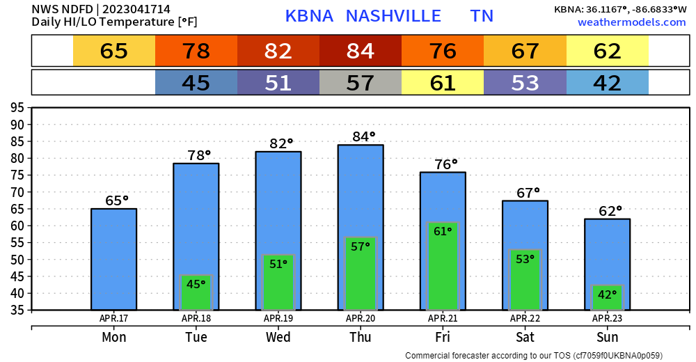
For this time of the year, temps will be a little cooler, but the air is dryyyy. Dewpoints as of 10am are in the mid 20’s, with relative humidity values around 30%. These dry conditions, combined with winds gusting from 20-30mph at times today, will lead to an increased fire danger. Recent rains will help keep this threat from being widespread, but don’t plan on starting a bonfire today.
Latest model guidance pushes back the arrival of the rain, we now look to stay dry until Friday AM. EURO and GFS models both agree, at least for right now, that Friday looks like a washout, with rain hanging around all day. So if you do have outdoor plans Friday, I’d start to seriously consider some indoor alternatives. Check back for updates as this could easily change.
Good news for people who enjoy running long distances around downtown Nashville, or people who enjoy just watching and cheering on, the rain looks to clear out for the most part by Saturday morning, leaving us with a fairly dry Saturday. Again, it’s Monday, and we are talking several days out, but at least some positive news for now.
No severe weather expected with any of this.
Quick References:
Weather changes constantly.
Follow @NashSevereWx on Twitter for any changes to this forecast.
Live coverage during tornado and severe thunderstorm warnings:

Look good.
Support the mission.

We are 100% community supported. No ads. No subscription fees. Keep it free for everyone.


Categories: Forecast Blogs (Legacy)
You must be logged in to post a comment.