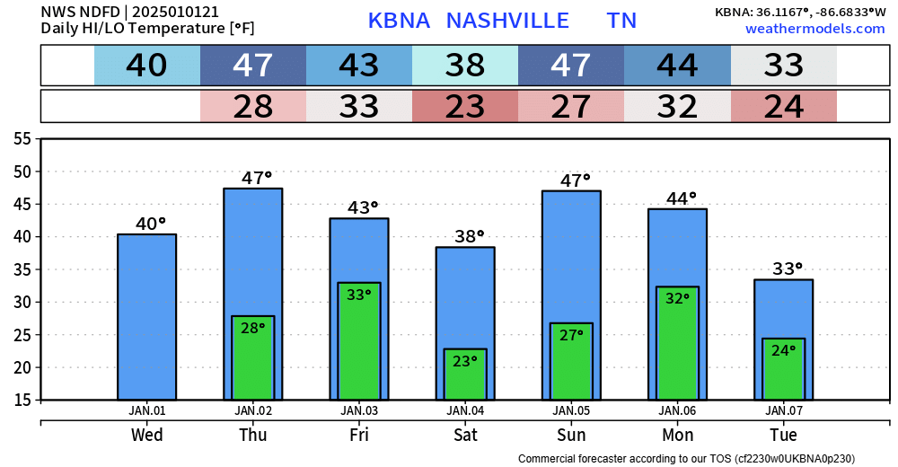
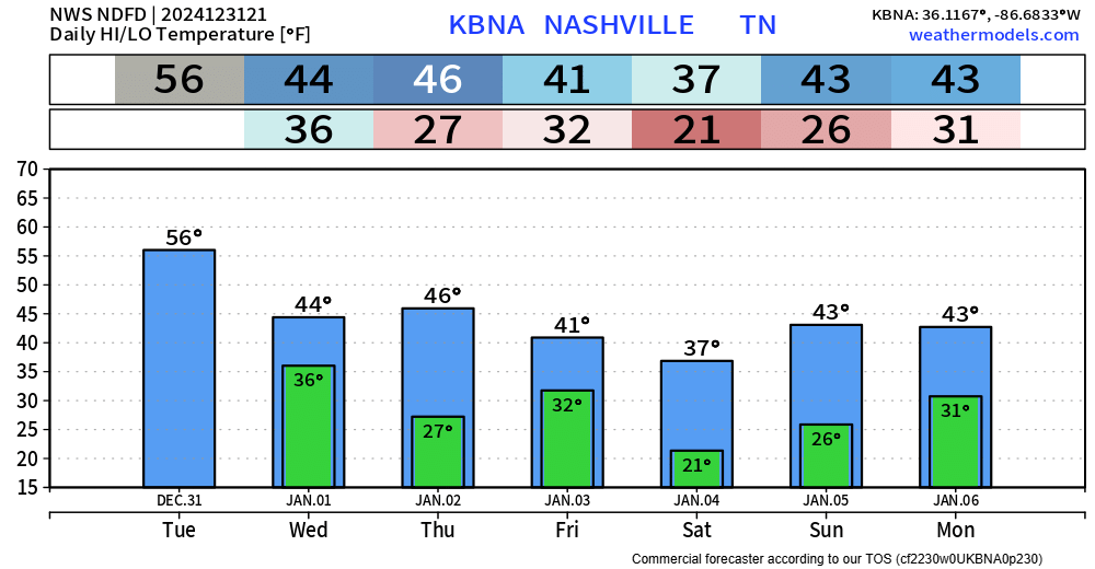
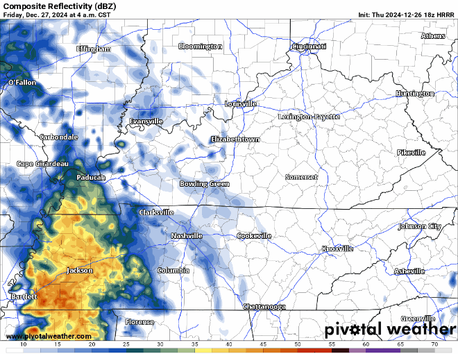
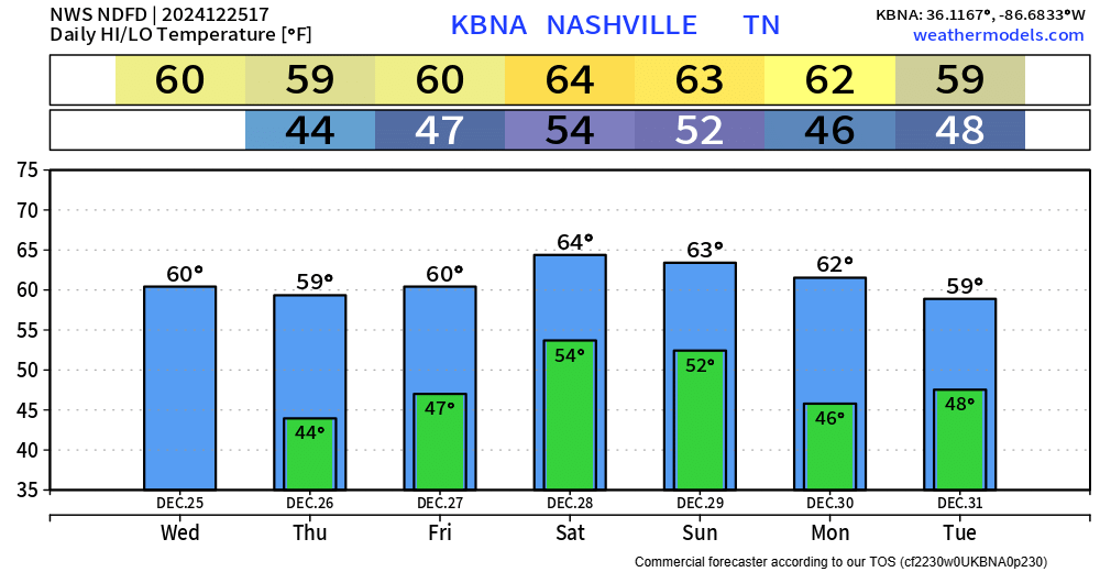
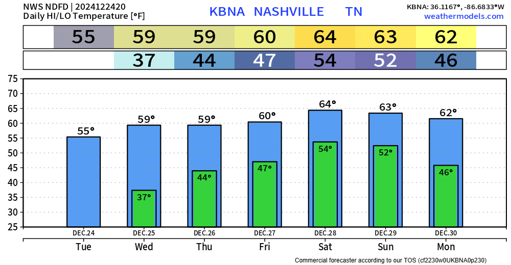
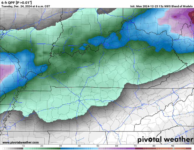
Relief From The Cold Is On The Way

As of 8:30am, BNA is reporting double digits temps (10°) for the first time in ~32 hours. Temps will rise to the low 20’s, along with some sun, will hopefully help some road conditions improve, but several roads will still be hazardous, continue to take it easy. The “warmer” temps should also help to relieve some stress on the power grid. read more

Dangerous Cold Will Stick Around, Then A Warm Up

Well, it snowed. Which has left some roads a mess, if you have to go out today, take it nice and easy. Also, the kiddos are probably going to want to play in the snow, however, this is not ideal playing-in-the-snow weather. In fact, it may be tongue stuck to flagpole cold. I wouldn’t try and see for yourself though. read more

Wind Chill Warning + Winter Weather Advisory Starts Tonight, Potentially Life-Threatening Cold

3:30PM Update:

This afternoon, Davidson Co. was upgraded to a Winter Storm Warning. Snowfall totals of 1-2″ are expected, with a few pockets of 3-4″ possible. Impacts remain the same as mentioned below in the rest of the blog. read more

Wind Chill Warning + Winter Weather Advisory, Dangerously Cold Temps and Light Snow

5PM Update:

NWS Nashville issued a Winter Weather Advisory for both of our counties from 6pm Thursday – 6am Friday.

They also extended our Wind Chill Warning, now starting at 10pm Thursday thru noon Friday, accounting for the expected earlier arrival of the cold front. read more

Dangerous Cold Temps + Light Snow Arriving Thursday Night

Today, Wednesday, and the majority of Thursday will be not too bad as high temps try to reach 50°. If you have something to do outside, I’d probably get it done now.

Thursday it should start raining sometime midday/afternoon. Then the arctic air arrives around 9p, give or take a few hours. Temperatures will plummet into the single digits overnight. High temperatures will struggle to make it into the teens on Friday, while wind chill values will not make it above zero throughout the day Friday and into midday Christmas Eve. A Wind Chill Advisory was issued for wind chill values of ten-fifteen degrees below zero, due to guests as high as 35-40mph. Temperatures will stay below freezing for “`~84 hours Thursday night into midday Monday. Anyone planning on going to the Titans game X-mas Eve needs to plan to really bundle up, as feel like temperatures will be in the single digits the entire game.

GFS Wind Chill: 6pm Thursday – 12am Saturday

Especially if you are heading out of town, but even if you aren’t, the time to prepare is now. read more

Dangerously Cold Temps Christmas Weekend, Snow Chances Are Iffy

Today through the majority of Thursday will be “nice” as temps reach the upper 40’s, maybe even low 50’s. Dry. Not too shabby.

Thursday night, temperatures are expected to plummet into the single digits/low teens. Temperatures will likely stay below freezing until midday Monday. This will leave us with dangerous conditions. It’s time to start preparing now, especially if you are heading out of town. read more

The Four P’s + The Possibility Of Snow

The days leading up to Thursday won’t be the best, but compared to the end of the week, it’ll feel like summer. High temps will actually slowly climb to the upper 40’s by Tuesday, with lows touching the freezing mark most nights. read more

Stupid Cold Incoming, Frozen Precipitation?

The days leading up to Thursday and Friday won’t be the nicest temperature wise, but compared to what the temperatures will be, you’ll be wishing we were in the 40’s…

Friday’s temps…yikes. Temps like that will linger around through Christmas weekend. read more

cold, then Cold

Temperatures will be fairly consistent for the next five days or so. Highs in the 40’s, lows in the mid to upper 20’s. That’s cold, but pretty average for this time of the year. Not really any meaningful chances for any precipitation, the GFS shows some showers on Monday, but other models think it’ll be too dry. read more

Just One More Rainy Day To Get Through, Then Cold and Dry

It has been a wet, damp, moist, whatever word you want to use to describe this morning, and it is only going to continue throughout the day.

The HRRR model (above) shows on/off rain really all day, before the rain finally pushes east of us at around 11pm, give or take an hour or so. read more