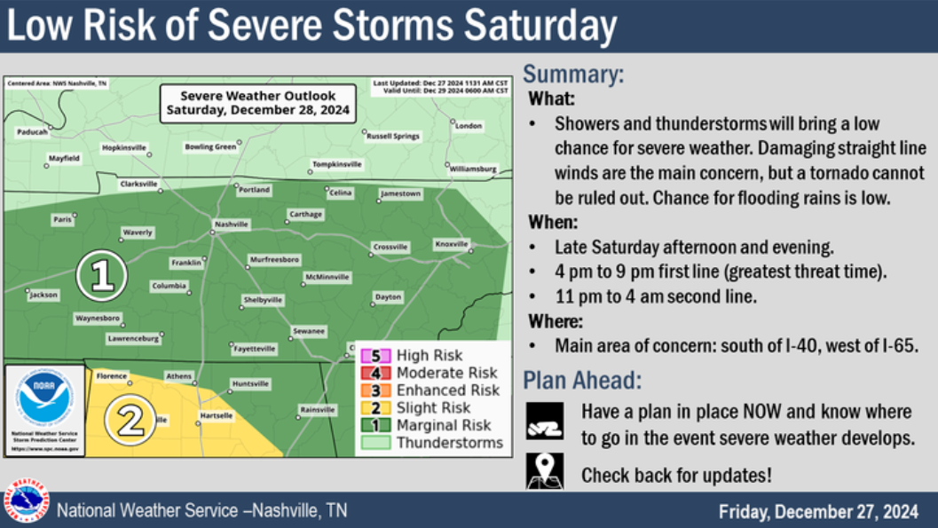
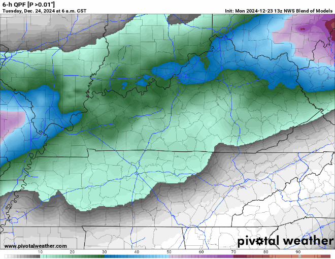
3:30PM Update:
This afternoon, Davidson Co. was upgraded to a Winter Storm Warning. Snowfall totals of 1-2″ are expected, with a few pockets of 3-4″ possible. Impacts remain the same as mentioned below in the rest of the blog.
Today, Wednesday, and the majority of Thursday will be not too bad as high temps try to reach 50°. If you have something to do outside, I’d probably get it done now.
Thursday it should start raining sometime midday/afternoon. Then the arctic air arrives around 9p, give or take a few hours. Temperatures will plummet into the single digits overnight. High temperatures will struggle to make it into the teens on Friday, while wind chill values will not make it above zero throughout the day Friday and into midday Christmas Eve. A Wind Chill Advisory was issued for wind chill values of ten-fifteen degrees below zero, due to guests as high as 35-40mph. Temperatures will stay below freezing for “`~84 hours Thursday night into midday Monday. Anyone planning on going to the Titans game X-mas Eve needs to plan to really bundle up, as feel like temperatures will be in the single digits the entire game.
Especially if you are heading out of town, but even if you aren’t, the time to prepare is now.
Today through the majority of Thursday will be “nice” as temps reach the upper 40’s, maybe even low 50’s. Dry. Not too shabby.
Thursday night, temperatures are expected to plummet into the single digits/low teens. Temperatures will likely stay below freezing until midday Monday. This will leave us with dangerous conditions. It’s time to start preparing now, especially if you are heading out of town.
Temperatures will be fairly consistent for the next five days or so. Highs in the 40’s, lows in the mid to upper 20’s. That’s cold, but pretty average for this time of the year. Not really any meaningful chances for any precipitation, the GFS shows some showers on Monday, but other models think it’ll be too dry.
Today will be a nice day as high temps reach the 60° mark. Cloud cover will move in as the day goes on.
The HRRR model (above) shows two rounds of rain for Wednesday. The first one beginning in the wee hours of Wednesday morning, hopefully clearing out by AM rush hour. The rain resumes around noon and continues through Wednesday night.
Not too bad of a day today, hoping the sun can peak through later, but cloud cover will dominate for the majority of the day. No rain.
Tuesday will be pretty much a repeat of Monday, except for high temps should be able to reach 60°. Can’t totally rule out some sprinkles during the afternoon, but the majority of the rain should hold off until after midnight on Wednesday.