The cold front that brought us some beneficial rain yesterday has cleared the area, leaving us with some cooler temps – unfortunately the cloud cover is being stubborn.
You can bet your bottom dollar.

The cold front that brought us some beneficial rain yesterday has cleared the area, leaving us with some cooler temps – unfortunately the cloud cover is being stubborn.
You can bet your bottom dollar.
Most, if not all, of us have seen some showers today. While the majority of it has moved off to the north, we expect another round of more consistent heavy rain after dark tonight.
Right now, the ETA for the heavier rain looks ~ 8pm, give or take an hour or so. Model data could be wrong!

A very nice November day today, unfortunately the same cannot be said about tomorrow.
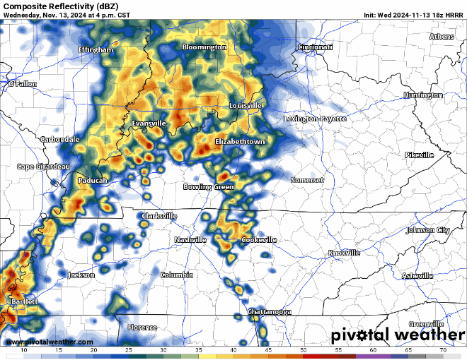
HRRR model (below) shows how most model thinks Wednesday plays out…
No severe weather expected! Maybe a rumble of thunder though. Good rain to sleep to.

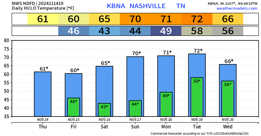
Temps will be cool to start us off Tuesday morning but will warm up into the low 60s – around average for this time of year.
Surprisingly, the GFS and Euro both have solid agreement on how our mid-week rain chances will play out.

Some more scattered showers (maybe a rumble of thunder) continue to move thru the area this evening. Things should wind down over the next few hours, you can view the radar anytime on our website here: Radar | Nashville Severe Weather

A nice Friday lies ahead, highs in the low 70s, no rain.
Unfortunately, we won’t have the luck of a dry weekend.
The GFS and Euro have come to a lot better agreement (at least for now) with what this weekend will look like in regard to rain chances.

Showers (heavy at times) are currently moving thru portions of our two counties. You can view the radar anytime on our website here: Radar | Nashville Severe Weather
Additional scattered showers will be possible throughout the day on Thursday. They’ll be light and quick – if you do see any. HRRR gives its’ best guess below.

Similar to yesterday, wind gusts of 20-30mph from the S have been common today but will relax after sunset. Scattered clouds have managed to keep our temperatures down today, and have only reached the mid 70s, short of our forecasted high of 80°.

Gusts between 20-30 mph have been common today due to a tightening pressure gradient. These strong gusts will continue thru Tuesday afternoon before relaxing.
Our dry weather will come to a pause Tuesday evening when a line of showers approaches – and won’t be in any hurry to get out of here.

Sunset was at 4:48p today, a new norm for the next few months…

Above average temps aren’t going anywhere either – with highs in the low 80s thru Tuesday, “cooling” down a tad to the mid 70s for the remainder of the week.
You must be logged in to post a comment.