Showers Arriving This Afternoon
Streamline of clouds currently blankets our skies as we wait for showers to arrive. Right now (10:58 AM), showers look to be just now making their way into the most northwestern portions of Middle Tennessee.

Streamline of clouds currently blankets our skies as we wait for showers to arrive. Right now (10:58 AM), showers look to be just now making their way into the most northwestern portions of Middle Tennessee.
Today and tomorrow look to be two pretty nice days with highs above average for the time of year. Sunny skies will prevail each day.
https://giphy.com/gifs/gutearbeitoriginals-perfect-top-l3q2LH45XElELRzRm
Temps today will stay near-average with highs topping off in the mid-40s. However, it may feel a bit cooler at times due to the cloudy skies and brisk winds. Winds will stay in the 10 to 15 mph, but some gusts as high as 20 mph are possible.
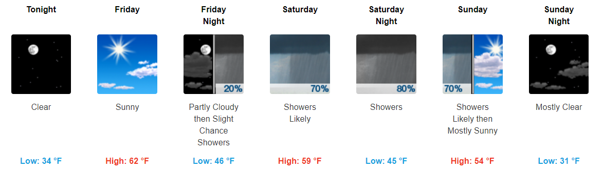
Happy weekend! This weekend looks fantastic for any outdoor plans you may have. Highs today will top off in the low-50s before reaching into the low-60s on Sunday. Enjoy the amazing weather!
https://giphy.com/gifs/veep-3o7qE32pRVNYJYKGBO
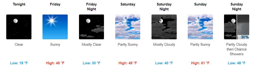
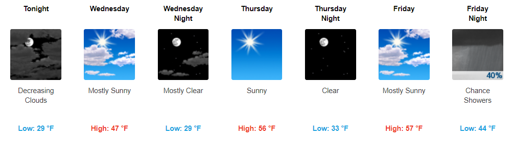
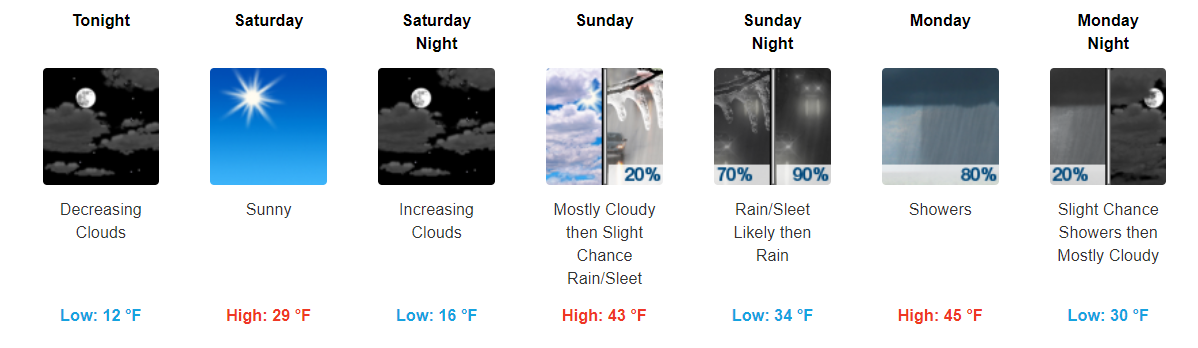
After the bitter cold temperatures we’ve had, the end is finally in sight. Today and tonight will still be on the chillier side with highs in the upper-30s and overnight lows in the teens.
Starting tomorrow, temps will climb into the 40s before reaching the low-60s (yes 60s!) on Sunday.
Thanks for all the snow total measurements sent today to #tspotter !
So far, four reports of 3" of snow in Davidson Co., a fifth report 2.7". Three reports of 3" in Williamson, one 3.5" in Brentwood. Several measured less snow, thank you!, nothing under 1".
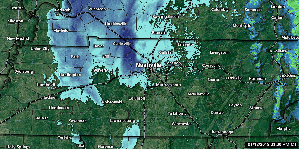
Current Radar Loop 3:00 PM to 3:40 PM
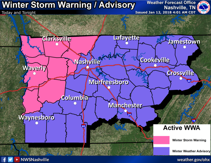
Snow showers have already arrived to our northwest and continue to move towards us. We are still looking at 1″ to 2″ of total accumulation for those north of I-40 and less than an 1″ expected for those south of I-40.
Note: models are showing different things. Some show more ice and/or snow, while others do not. These are just very rough estimates.
Already this morning we have see plenty of rainfall. The freezing line is currently knocking on our doorstep, which will turn our rain showers into a wintry mix very shortly. Expect for the wintry mix to arrive in the next hour or two.
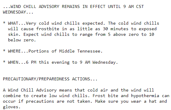
Frigid temps continue today and tomorrow. Temps will not reach to above freezing until Sunday. Stay bundled up over the next 48 hours folks.
https://giphy.com/gifs/cold-freezing-101-dalmatians-NrwULs858gcms
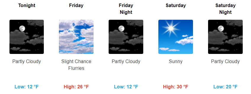
Yesterday, we had the pleasure of seeing some temps above freezing for a little while. Unfortunately, temps have fallen back below freezing and look to stay there through Saturday.
https://giphy.com/gifs/snl-3oEjHKj26YqQmAFgqY
You must be logged in to post a comment.