Current Official Hourly Observation (taken at :53 on the hour)

Temps Next 24 Hours (auto-updating)
Current Radar Loop
![]()
Tonight – Warm, Chance of a Shower or Thunderstorm – Low in the low 50s

Current Official Hourly Observation (taken at :53 on the hour)
Temps Next 24 Hours (auto-updating)
Current Radar Loop
![]()
Tonight – Warm, Chance of a Shower or Thunderstorm – Low in the low 50s
(Editor’s Note: This post was written by Bobby, the Intern Applicant who took a shot at Peyton Manning on his first go-around).
Current Official Hourly Observation (taken at :53 on the hour)
Current Official Hourly Observation (taken at :53 on the hour)
Temps Next 24 Hours (auto-updating)
Current Radar Loop
![]()
It’s Severe Weather Awareness Week across the State of Tennessee. The NWS picked the right week — there’s a chance of severe weather Thursday.
Current Official Hourly Observation (taken at :53 on the hour)
Temps Next 24 Hours (auto-updating)
Current Radar Loop

It’s Severe Weather Awareness Week across the State of Tennessee. The NWS picked the right week — there’s a chance of severe weather Thursday.
Current Official Hourly Observation (taken at :53 on the hour)
Temps Next 24 Hours (auto-updating)
Current Radar Loop
As you can see on the above radar, a shortwave trough is spreading light rain into Middle Tennessee. This precip should last until midnight.
Current Official Hourly Observation (taken at :53 on the hour)
Temps Next 24 Hours (auto-updating)
Current Radar Loop
Today – Chilly – Afternoon High 35

We may see a shot of rain later tonight. According to this model, the freezing line should be just north of us (even though we are forecast to be below freezing), so we aren’t expecting any snow/flurries — but the NWS Is not ruling that out, either.
Current Official Hourly Observation (taken at :53 on the hour)
Temps Next 24 Hours (auto-updating)
Current Radar Loop
Tonight – Rain Ending; Black Ice Possible Late – 9p 35, Midnight 30, 3a 26
Current Official Hourly Observation (taken at :53 on the hour)
Temps Next 24 Hours (auto-updating)
Current Radar Loop
Today/Tonight
A cold front is shoving rain across Tennessee today. The leading edge was at the TN River around noon. Check out the rain’s current location on the radar, above.
Current Official Hourly Observation (taken at :53 on the hour)
Temps Next 24 Hours (auto-updating)
Current Radar Loop
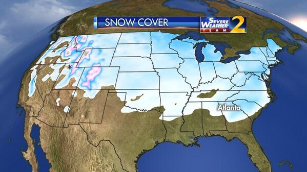
Behold, the #SnowDome:
Tonight – Increasing Clouds – 9PM 38, Midnight 35
Current Official Hourly Observation (taken at :53 on the hour)
Temps Next 24 Hours (auto-updating)
Current Radar Loop
What Happened Today?
We woke up to freezing temps; however. above-freezing temps overhead arrived with the precip, preventing snow from forming. Instead, we just got rain.
You must be logged in to post a comment.