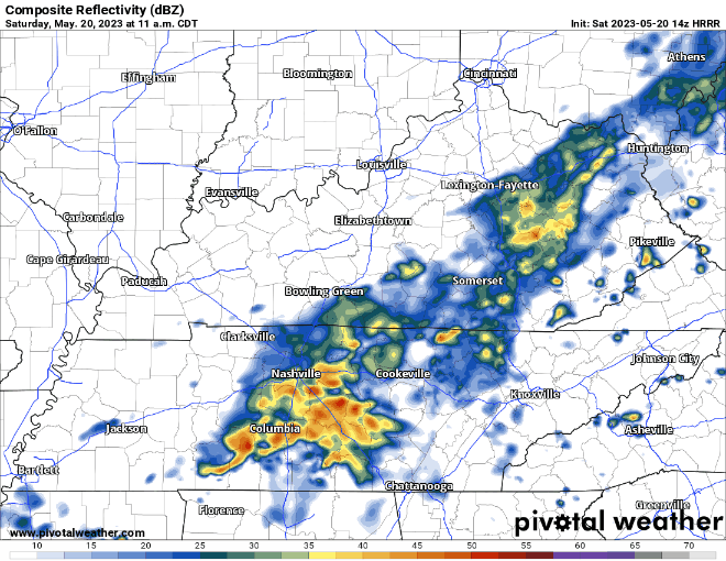
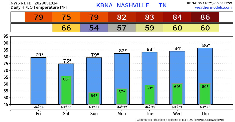
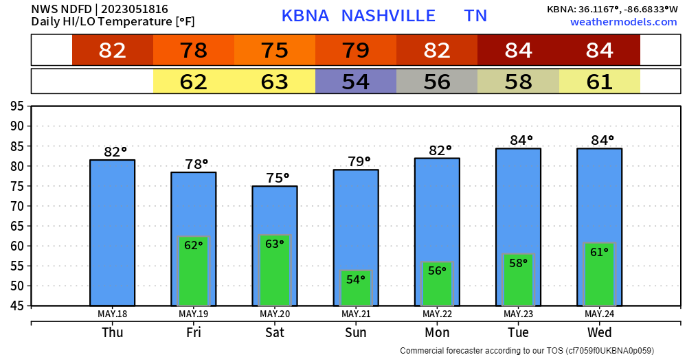
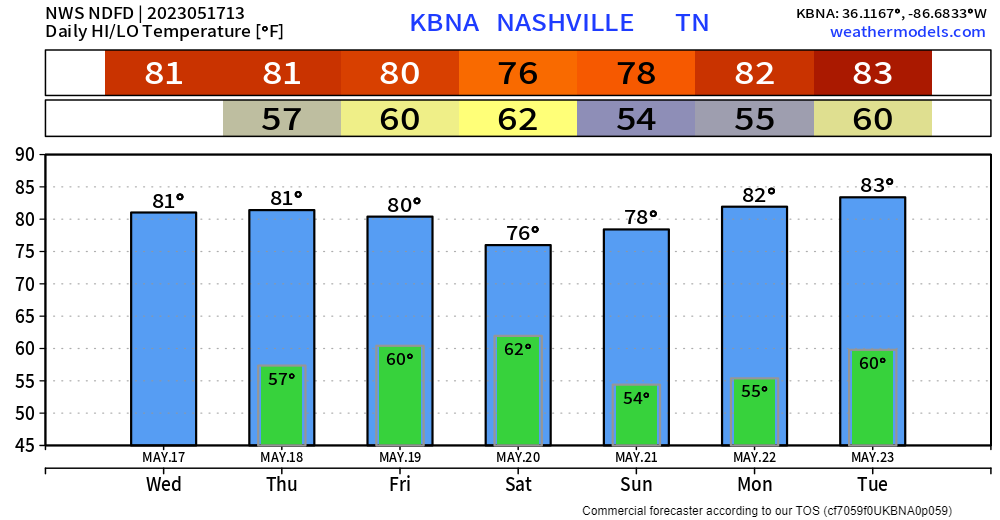
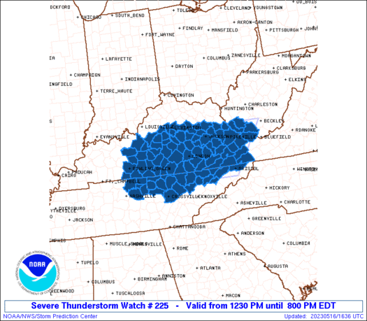
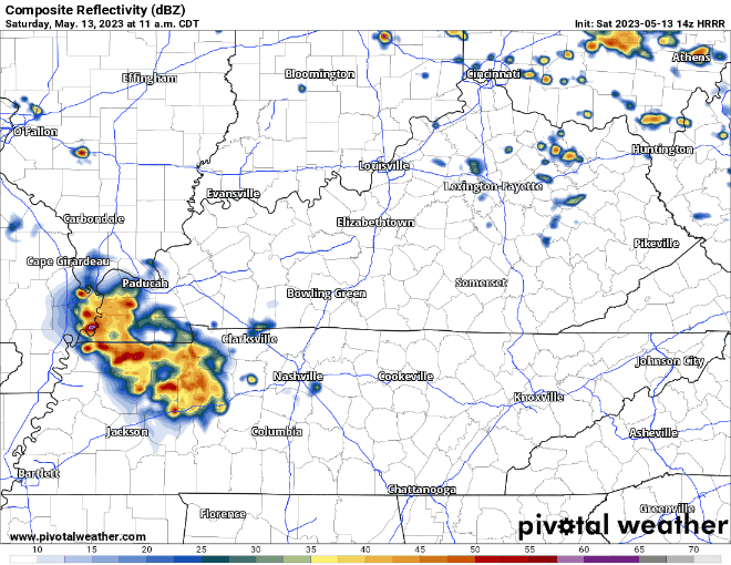
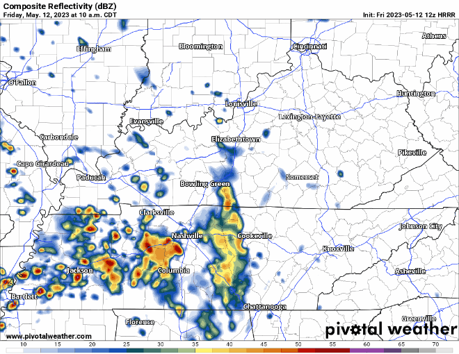
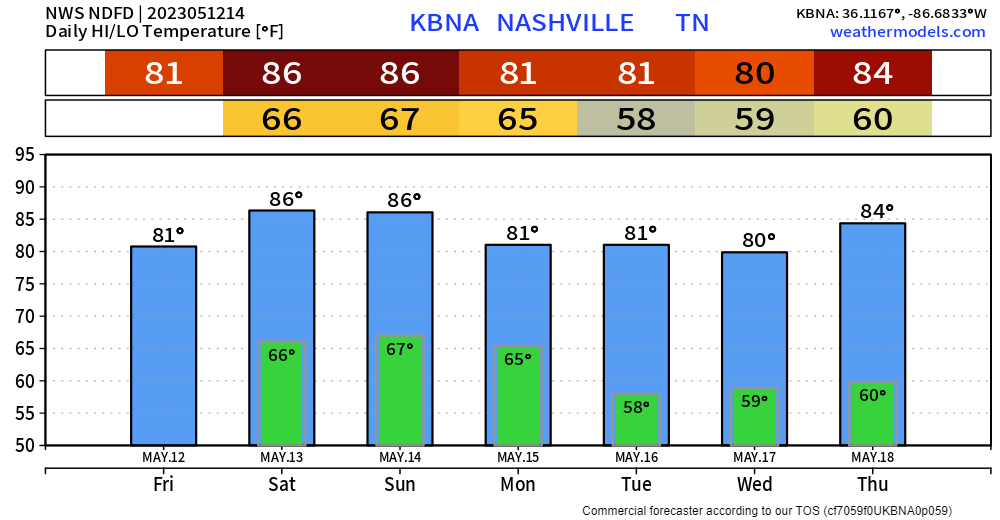
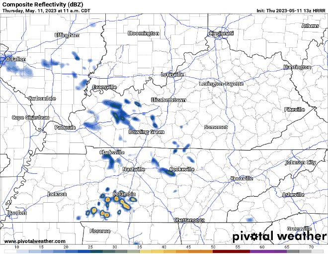
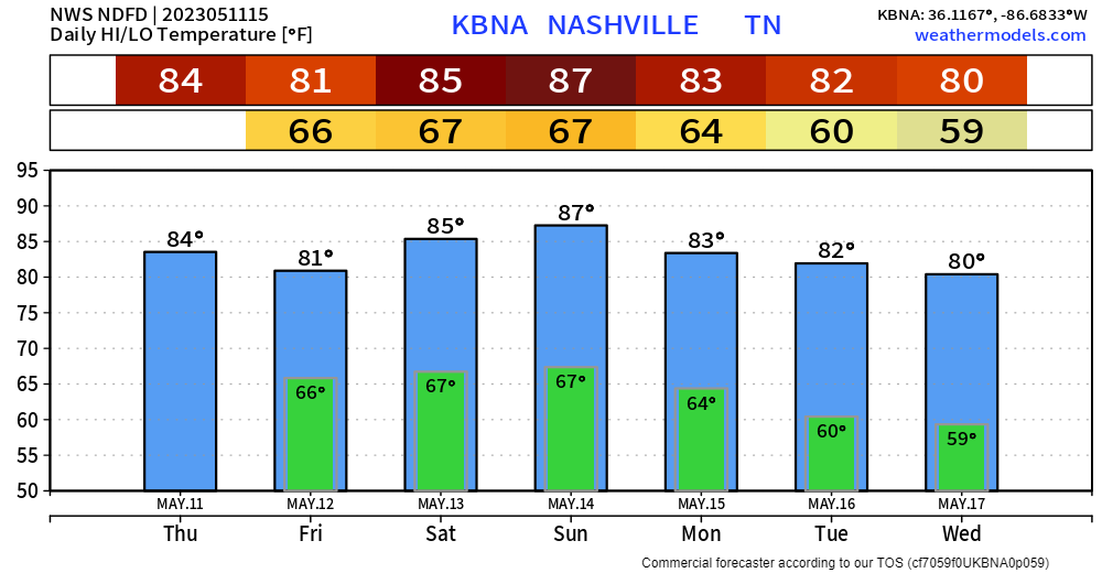
2sday Feat. Two Days With Some Rain & Storms Around

Rain and storms are likely today but the question is when?

  • The overnight models were all convinced storms would form mid/late afternoon and last into early evening.
  • Latest NAM/HRRR models have the afternoon quiet with storms forming after dark.
  • It makes more sense that they would form late afternoon to dark, say like around 4 PM to 8 PM. We’ll see.

Storm hazards today/tonight:

  • Heavy rain in spots, with flash flooding possible; WPC has a 10% to 20% probability of flash flooding within 25 miles of you
  • CG (cloud to ground) lightning
  • Low probability of damaging straight line winds in a few isolated spots
  • I suppose we could see some small hail but that’s also unlikely
  • Not worried about tornadoes.

Rainfall should be heavy in spots but unevenly spread, like what happened yesterday thanks to @SoccerMoses:

https://twitter.com/SoccerMoses/status/1556841249398726658?s=20&t=QOb6Lzz2GOmdqBzK6-Eb-Q

Everyone on the interstate was winning the Wattery in that moment. Thank you Soccer Moses! read more

Four More Days Of Wattery, Then Suh-weeet Relief

Classic Wattery Today Through Thursday.

Monday: Probably Nothing.

  • Spilled paint below is just a bunch of models on one display suggesting rain is Quite Unlikely (but maybe still possible) today.

Tuesday: A Bit More Likely.

  • HRRR model has rain Tues morning and again late afternoon/early evening, see below.
  • Rain may be excessive. 5% probability of flash flooding within 25 miles of you Tuesday. Poor eastern KY, they keep getting hammered by rain.

Wednesday: Likely the Wettest, Stormiest.

  • A continuous rain is unlikely, but expect rain off and on during the daylight hours.
  • Flash Flood probability straddling the 5% to 10% and 10% to 20% line. Average rainfall around a half inch, but some will get more, others much less.
  • Severe weather unlikely in the classic sense (large hail, tornadoes, long tracked damaging straight line wind swaths), but like we’ve seen this past weekend in Donelson, microburst winds will be possible as storms collapse and bring a lot of sudden straight line wind with it.
  • CG lightning also likely in these storms. Don’t be far from lightningsafe enclosed structures.

Thursday: One More Wattery Day This Week

  • Chances meh, so more water losers than winners.
  • Last day of big humidity?

Friday – Weekend: Sweet Relief

  • Humidity drop! We’ve been stuck with 70°+ dewpoints for a while, we’re all getting used to it. Dewps drop into the 60°s and even into the upper 50°s Saturday, before re-rising back near 70° late Sunday/Monday. Far from Fall Weather but still pretty nice for mid-August.
  • No rain in the weekend forecast (so far!).
  • There’s still time for the model data to change.

Quick References:

Weather changes constantly.
Follow @NashSevereWx on Twitter for any changes to this forecast.

Live coverage during tornado and severe thunderstorm warnings. read more

It’s The Sunday Edition. Readers Demand More.

A long time ago – very long even! – a man got in an airplane, went up instead of sideways, flew to the dang moon and walked on it. So here in 2022, it is reasonable for us all to expect in this here age where George Jetson Has Been Born that I could possess easy answers to your reasonable, common, simple weather questions like: when will it storm on my flying car today? read more

No Genie, But Genuine Answers For Rain/Storm Chances This Weekend

So many questions, so many variables, so many different outcomes, few answers. This blog may not contain the answer(s) you are looking for, but it’s the honest answer. The Wattery is random. If a genie gave me three wishes, my first wish would be to have the knowledge of when/where the Wattery would strike. But since I don’t personally know any genies, here I am giving you vague, yet honest answers. read more

Trying To Dodge Uncertainty With Daily Rain Chances

Rain just to our west this morning. HRRR model (below) thinks it slides a little this way during the afternoon and some of us may get some rain and lightning before it pushes north. For tonight, the HRRR thinks more Wattery style showers/storms pop-up sometime this evening. read more

Can’t Shake The Uncertain Rainy Pattern

Another hot + humid day with the heat index maxing out near 100°.

HRRR model (below) think the showers/storms in Arkansas and West TN slowlyyy make their way here, if they make it at all. ETA would be sometime in the evening. HRRR model doesn’t think there are any Wattery chances but cannot rule one or two out. No widespread severe weather is expected but a storm or two could have some strong straight-line winds and some heavy rain. read more

Playing The Wattery Everyday

Muggy today, high of 93° paired with dewpoints in the low 70’s will send heat index close to the triple digits.

HRRR model thinks only a couple winning Wattery tickets will be sold today. Your guess is as good as mine as to where those winning tickets may be. No severe weather expected, but a storm or two could have some heavy rain and strong winds. read more

Typical August Weather, Ft. Help From Paintballs

It will certainly feel like August as high temps get into the low 90’s, although we could fail to make it there if cloud cover starts to dominate. Dewpoints in the low 70’s will make it feel gross. read more

August Comes In Like A T-Rex, Out Like A ?

A t-rex may seem really intimidating. However, it has such tiny arms that it kinda makes you laugh. Maybe if they hadn’t gone extinct, they’d be a lot more terrifying too, but since they are, and they can’t prove me any differently, I think the intimidation factor goes away after you laugh at their tiny arms. read more

Some Rain Out, But Meh? Heat + Humidity Returns This Week

Most of the rain today stayed west. Tonight the heaviest showers will be south. Few showers possible later this afternoon and tonight:

We are not worried about any severe weather.

Recently we’ve seen the heaviest rain over Will Co. and parts of Nashville south of I-40: read more