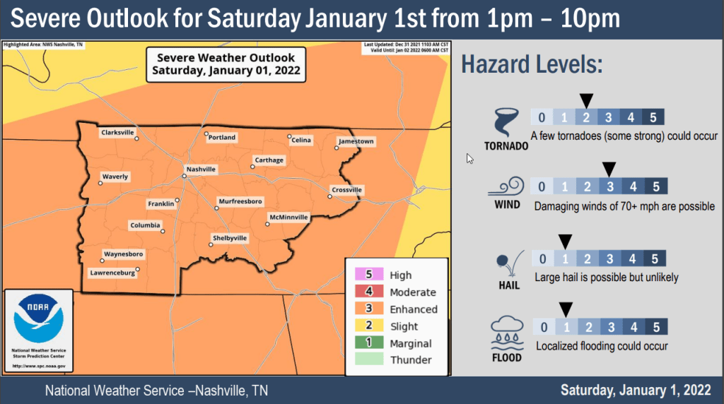
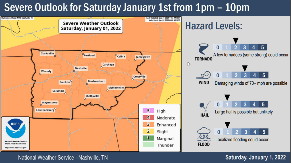
The 13z HRRR model run shows supercells and multicell storm clusters forming ahead of a cold front this afternoon.
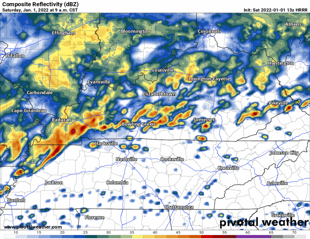
These storms will rotate. Some rotating storms will be capable of producing damaging straight line winds, tornadoes, and hail.

The 13z HRRR model run shows supercells and multicell storm clusters forming ahead of a cold front this afternoon.
These storms will rotate. Some rotating storms will be capable of producing damaging straight line winds, tornadoes, and hail.

Rain will be off and on today. It’s coming in from Arkansas (where rain is a bit heavy, with a few thunderstorm), but as it moves toward us the storms will dissipate and the rain will break up into light rain, turning off and on. Temperatures will be in the upper 60s.
Nothing major happening this weekend. A warm front sunk south this morning and brought drizzle. We are now on the cold side. Temperatures have cooled down since yesterday.

Starting at 2pm today, the annual Christmas Parade in Franklin will be happening. No major concerns.
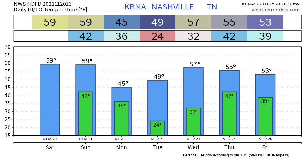
Temperatures will get up to around 60 today thanks to a warm front that moved in last night. Tonight, lows will be in the lower 40s.
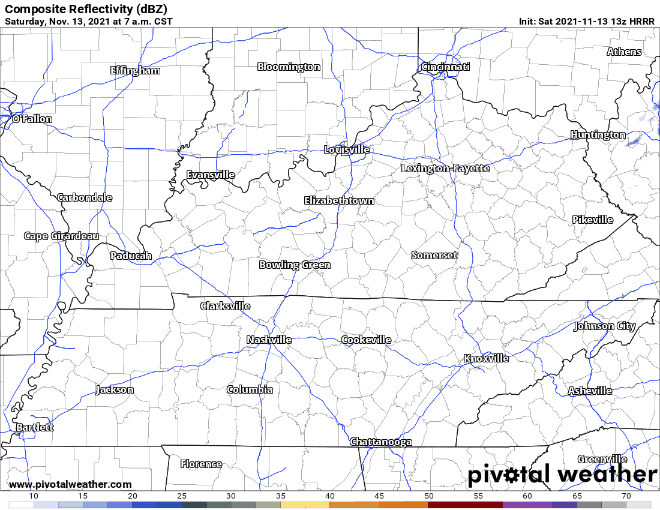
The HRRR (above) shows there will be no rain today. It will be mostly cloudy.
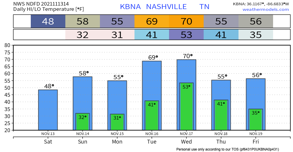


The HRRR below is showing no rain in Tennessee today. Skies will be mostly sunny with a high of 49 degrees. If you are going out today, it would be good to grab a jacket or coat.
Tomorrow will be similar to today; no rain. It will be warmer tomorrow with the high around 60 degrees.
The generally dry weather we experience in the fall is taking a break as we deal with some cold gross rain behind the recent cold front.
While most of the rain for the day fell this morning, drizzle and mist will likely stick around for the rest of the afternoon. This will make the 57° high feel pretty chilly.
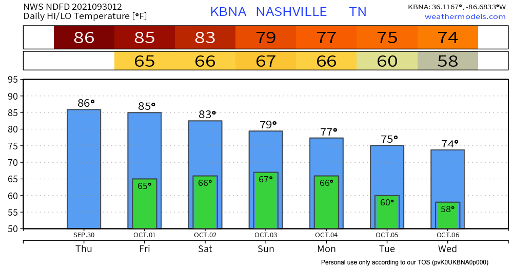
Temperature highs will be in the low 80’s and lows will be in the high 60’s. Chances for scattered showers are possible today (HRRR shown below).
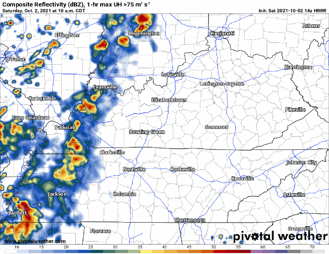
The model is showing that some showers pop up around 5 and are off and on through the evening. Rain today and tonight should not be heavy, but we can’t rule out a rumble of thunder.
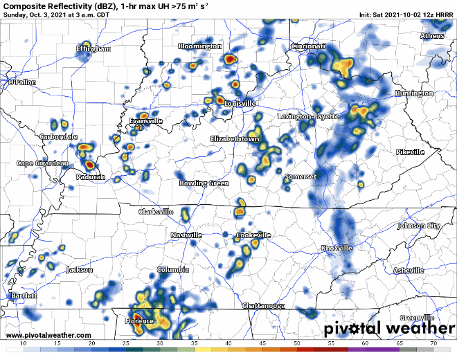
Rain is expected in the early morning on Sunday. Rain continues off and on through lunchtime or maybe mid-afternoon (3-4 pm). The evening will be mostly overcast with still a chance for light occasional showers later into the night as things move out.
Some of the Sunday rain could be on the stronger side. The only concerns would be strong wind gusts and heavy downpours.
A closed low will circle around our area… see the morning AFD for an explanation.
A shortwave will dive south out of Minnesota/Wisconsin toward Arkansas Sunday night and quickly become a closed low by Monday evening. The closed low will spend the rest of the work week meandering around the Southeast and eventually the Ohio River Valley. This will put us in a cloudy, cooler, and wetter pattern than what we have seen over the past week. The highest PoPs areawide after Sunday will be Tuesday afternoon as the upper low lifts back north and west

Those who live near fast-rising creeks and streams should pay close attention to the weather this weekend. If a Warning is issued, be sure you are paying attention and can move to higher ground. No one should attempt to drive across a flooded road.
Editor’s Note: Flash Floods. We’ve been through them. They’re a painful reminder of how quickly weather can take away what has taken years to make…homes, businesses and beautiful landscapes. Today, our friends just to our west are dealing with catastrophic flooding with well over 11 inches of rain, maybe much more, falling just this morning. The beautiful Piney River is roaring at 31.8 ft at the time of this writing, a staggering 7.8 ft above MAJOR flood stage. If you have friends in Humphreys, Hickman, Dickson or Houston Counties, please check on them by phone/text if you’re able. They’re going to need much to rebuild what water has taken away today.
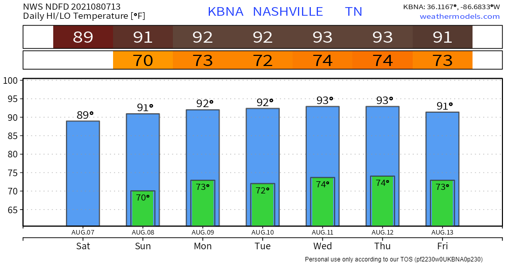
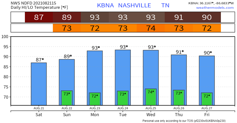
Our cooler temps, lower humidity streak is over. Humidity is up today. It’ll stay there for the foreseeable future. Temps return to normal for August.
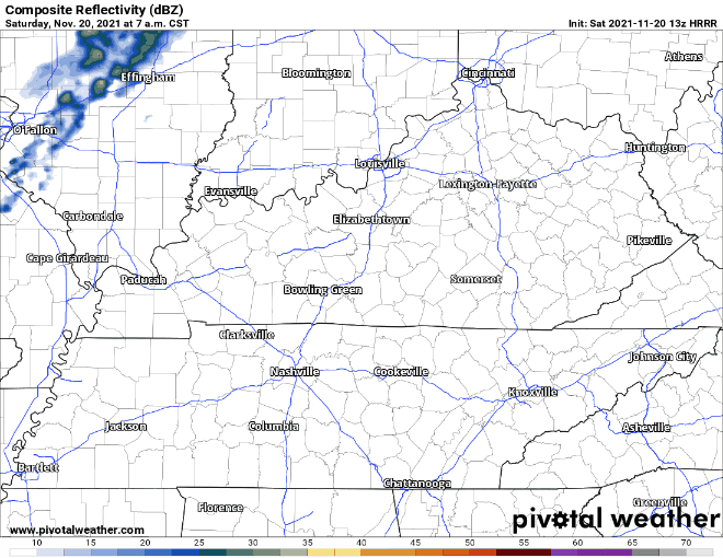
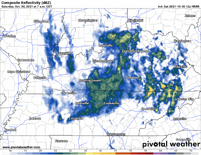
There are a few thunderstorms south of us this morning. They’re moving east and won’t bother us. We may see light rain this morning but the bigger rain and storms should be east of us all weekend. Here is the HRRR model showing the weekend:
You must be logged in to post a comment.