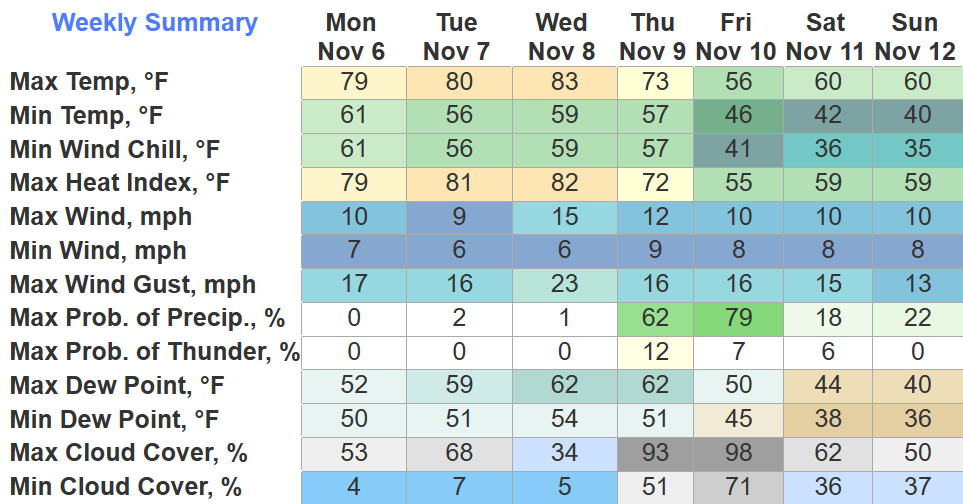
As of 4pm, Nashville has tied the daily record high at 79°. Tuesday the record high is 80°, Wednesday it’s 83°, both days we will get close to tying/breaking that record. Is it November or April?

As of 4pm, Nashville has tied the daily record high at 79°. Tuesday the record high is 80°, Wednesday it’s 83°, both days we will get close to tying/breaking that record. Is it November or April?
New drought monitor came out today and did not bring good news.
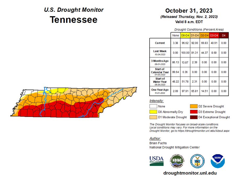
The southern half of WillCo. is now under an Extreme (3/4) Drought, while the rest of us are under a Severe (2/4) Drought. We haven’t experienced an Extreme Drought since 11/29/2016. Very, very little rainfall is to blame, and unfortunately, it looks to get worse before it does better.
Once again, we will be headed down below freezing tonight, 28° is the official low at BNA but your place will probably be a few degrees colder. Thankfully winds will be calm and there won’t be much of a wind chill.
You’ll really have to earn the candy tonight as you fight a jerk NNW wind. Winds will pick up over the next few hours, gusting up to 20mph. As of 6:30p, temperatures are in the mid 40s, but will quickly drop to the upper 30s by 8pm, but with the wind it’ll feel like the lower 30s. Might want to hit a light jog in-between houses to keep warm.
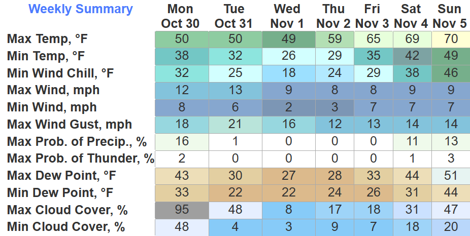
The cold front has pushed thru and brought some chilly (chili?) weather. The light rain will shortly end, leaving us with a dry, jerk north wind.
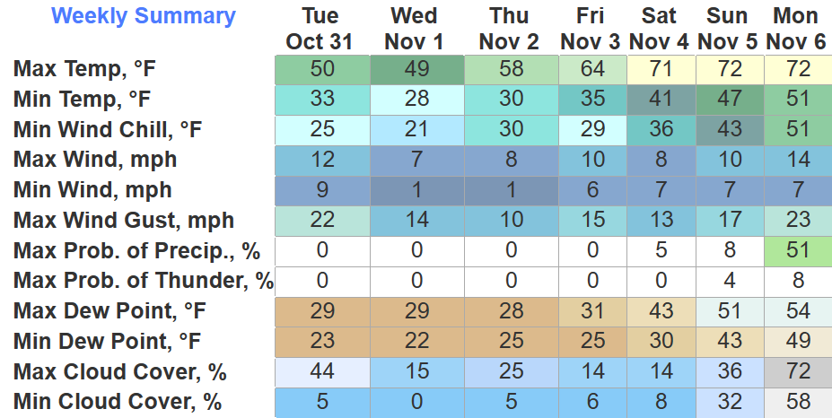
First freezes of the season mean Freeze Warnings have been issued, 3am to 9am Tuesday, and again 10pm Tuesday thru 10am Wednesday. “Frost and freeze conditions will kill crops, other sensitive vegetation and possibly damage unprotected outdoor plumbing.” Prepare as needed.
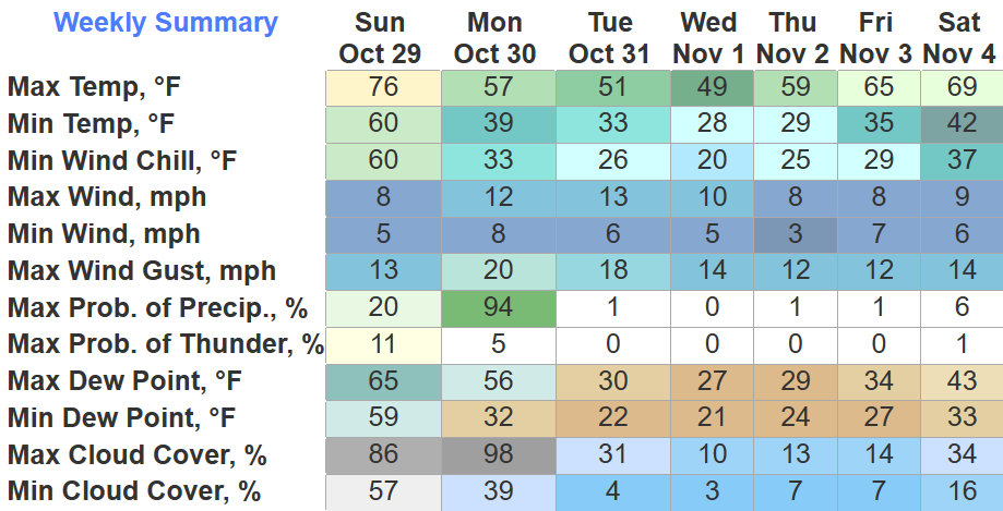
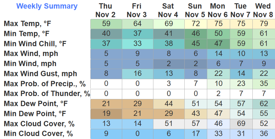
Thankfully the rain held off for the Oilers dub, not a half bad Sunday. Temps are in the 70s for the last time for at least the next six days.
Overnight the cold front will bring rain and open the door for colder temps.
Besides a few stray showers, not a half-bad Saturday lies ahead of us. Temps already in the upper 70s as of 10am.
Sunday will have temperatures in the 70s for the last time for a while, rain chances also pick up.
Some sprinkles possible throughout the remainder of the day, but I see no need to alter any plans. Maybe keep a rain jacket close.
Saturday will be much of the same, mostly dry, some brief light showers are possible, again, nothing seems to be plan-altering.
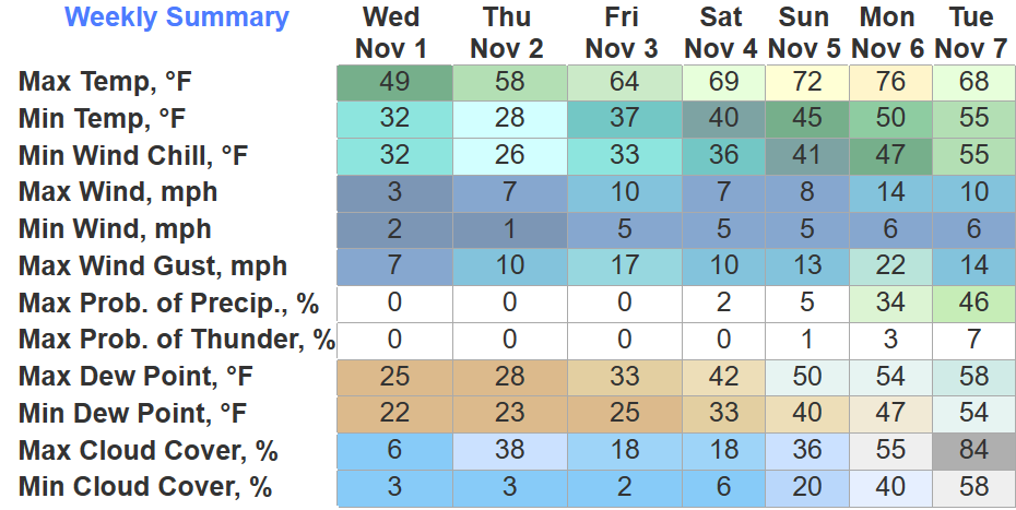
The latest drought monitor update come out today and did not have any encouraging results, unsurprisingly. The southern half of WillCo. is now under a Severe Drought (2/4), with the rest of us remaining in a Moderate Drought (1/4). With our lack of any recent rainfall, this isn’t a shocker. But is there any relief coming?
Another pleasant day and tomorrow will be more of the same. Still a lot warmer that what we are used to this time of year.
Rain chances finally come back around Friday.
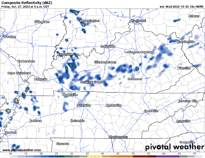
The HRRR model (above) shows showers creepin’ in Friday AM and staying on/off throughout the day. Any rain we see would be light, so not thinking any rainouts.
You must be logged in to post a comment.