If you are up right now, props. If you see this in this morning – that’s okay too, it’s late.
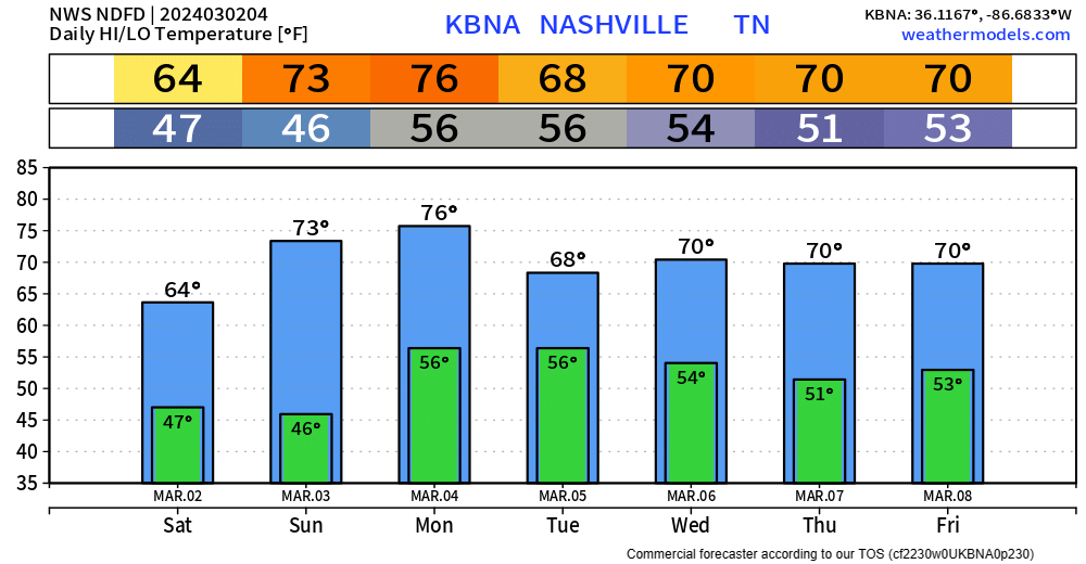
We get rewarded with a warm + dry weekend.
Dry weather can’t last forever as rain chances return Monday, and last thru mid next week.

If you are up right now, props. If you see this in this morning – that’s okay too, it’s late.
We get rewarded with a warm + dry weekend.
Dry weather can’t last forever as rain chances return Monday, and last thru mid next week.

Chilly day today, and tomorrow will fairly similar but with rain chances.
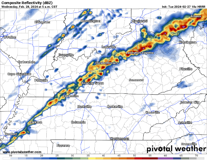
HRRR model (above) shows rain beginning early Friday, lasting on and off throughout the day. No severe weather concerns, just a cold rain. Bleh.
This morning, temperatures were in the low 70s. As of 6:45pm, we are in the low 40s, and on our way to about 28° tonight. Your backyard may be a few degrees warmer/colder.
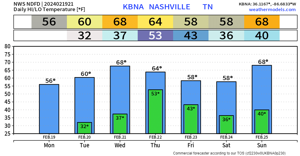
We’re expected to barely make it to 50° on our extra day for 2024.
Another warm day despite the cloud cover.
Wind Advisory is in effect now thru noon Wednesday. Wind gusts up to 40 – 45 mph will be possible.
Early Wednesday morning, a line of rain/storms is expected to move thru. Severe weather is not expected, but a storm on the strong side cannot be ruled out.

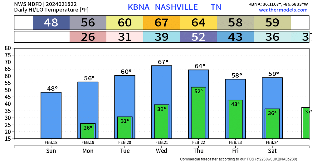
Beautiful day today, 3 degrees short of the record high of 79° at BNA.
Similar temperatures for Tuesday, but we have some non-thunderstorm winds and rain to deal with.
A Wind Advisory will go into effect starting noon Tuesday and go thru 6am Wednesday. Sustained winds around 20mph, with gusts up to 40mph will be possible. Secure any outdoor furniture and bring in those trash cans ASAP.
A bit chilly today, but it could be worse. Lows will dip into the upper 20s tonight, brr.
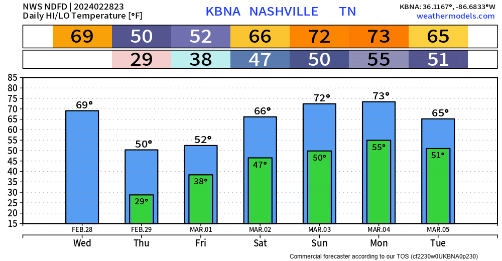
Good news is that we will quickly warm up to start off the week.
Mid 60s on Sunday, getting into the low to mid 70s on Monday and Tuesday.
Splendid day today, unfortunately the same cannot be said about the forecast for tomorrow.
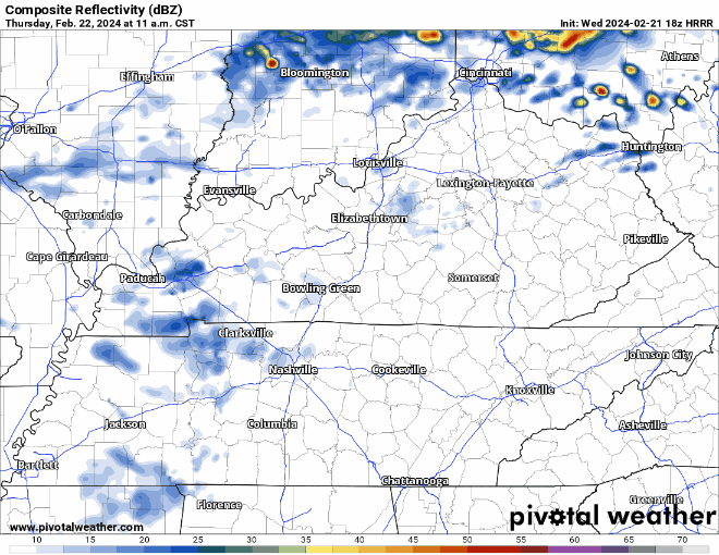
The HRRR model, displays what it thinks the radar *could* look like tomorrow.
We’ll dry out Friday and should get away with a dry weekend except maybeee some light, quick showers Saturday morning.

Really nice day today, BNA got up to 64° for a high temperature.
Tomorrow will be more of the same, high temperatures will get close to 70°. Winds will pick up tomorrow afternoon, gusts up to 20 – 25 mph will be possible.
Warm + dry weather expected the next two days. High temps get into the low 60s tomorrow, and even surge into the upper 60s Wednesday.
Our relative humidity values will be in the low to mid 20% range Tuesday and Wednesday, but thanks to recent rains and light winds (besides Wednesday), our fire danger will remain very low.
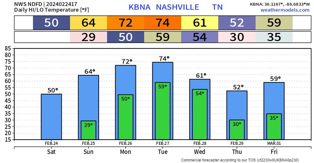
Sun feels a lot better than the shade, but overall, pretty chilly. Thankfully, we have a good warm-up coming up.
High temperatures will be back in the 60s by Tuesday and remain there for several days. Nice weather all week besides Thursday.
You must be logged in to post a comment.