
Cold mornings ahead this week. We’ll wake up to temps in the low to mid 40s Tuesday morning.
Frost will be likely Wednesday and Thursday mornings, potentially Friday morning as well, with lows in the mid 30s.

Cold mornings ahead this week. We’ll wake up to temps in the low to mid 40s Tuesday morning.
Frost will be likely Wednesday and Thursday mornings, potentially Friday morning as well, with lows in the mid 30s.

A cold front will move thru tonight, bringing in a much cooler and drier airmass.
High temps in the low to mid 60s will be common throughout the work week.
Frost will be likely Wednesday and Thursday mornings, with lows in the mid to upper 30s. Jackets will be needed to walk out the door this week.

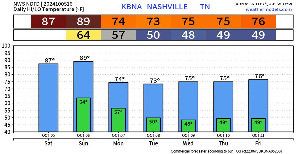
Warm weekend, borderline hot on Sunday. Plenty of sun and evenings will be cooler.
A cold front will push thru Sunday evening, it could bring a shower or even a storm to the Plateau, but we are expected to stay dry here.

Another day of beautiful weather. More of the same Saturday.
Sunday gets borderline hot. High of 87° would be one degree short of the daily record high.
Sunday evening a frontal passage will knock down temps for the week. It also could squeeze out a shower or two Sunday PM, but those chances are primarily to our NE, we should stay dry.

Nice weather this weekend. Light jacket for the mornings and warm afternoons. Still no rain expected in at least the next 7 days.
A front will pass thru and set us up for some lows in the 40s by early next week. High temps only reaching the mid 60s.

Not to sound like a broken record, but more cool mornings and warm afternoons ahead. Still no rain in sight.
Sunday night another cold front will move thru and knock temps down and starting early next week we’ll get cool (cold?) mornings and cool-ish afternoons.

Another spectacular day ongoing, nice temperatures, dry. Can’t complain.
The same forecast will hold true for at least the next 10 days or so. Cool mornings, warm afternoons, and still no rain in sight for at least the next 10 days.

Temperatures today are roughly 15° cooler today than they were at this time yesterday. Very welcomed.
The NWS Blend of Models suggests these nice temperatures continue thru the next 10 days. Cool mornings and warm afternoons, fairly typical for early-to-mid October.

Today could be our last 90° day of the year (fingers crossed, but no promises).
A cold front will come thru overnight and knock down the temps and dewpoints, making it feel more like early October throughout the week. Cool mornings, warm afternoons.
Today and Sunday will be our last “hot” days for the foreseeable future. Upper 80s today, even pushing 90° tomorrow.

A cold front will push thru Sunday night, escorting cooler and drier air – making it feel more like October.
You must be logged in to post a comment.