Nicer/Still Humid Monday; Then More Awful Humidity

The radar relocated to the bottom of the page. I got sick of looking at it at the top.

Tonight: Looks Good

The front that was making me rain-nervous for those along and S of 40 has finally dropped along 840, as seen here at 4:16 PM:


Tonight looks fine for outdoor activities. Any rain that develops will move south.

Monday: Best Day of the Week, High 91°

Drier air arrives, shoving dewpoints out of the 70°s and into the still-humid upper 60°s. Rain is not expected.

Tuesday & Beyond: Humidity, Rain Chances Return

Dew points will return into the low 70°s. Gross.

NWS-Nashville wrote today:

Will carry chance probabilities of precipitation all week due to no one day/area seeing a better shot than the next.

Meaning, it may rain each day, but we don’t really know when. If you read this, maybe the odds are higher Tuesday. I can’t explain that.

Afternoon/Early evenings more likely to produce rain. Maybe too much rain:

While the threat for severe weather will be low, we will need to monitor the rainfall accumulations each day. The cumulative totals throughout the week could end up causing some very localized flooding issues. read more

Summer Happening

For no good reason, I put the radar at the bottom of this page.

Today: Only 89°

This morning, I doubted it would rain. Well what do you know, that seems like a bad forecast a few hours later. Can’t wait for summer to end. 


A front passed by last night, so today we get a north breeze. That breeze is really only happening north of I-40.

You’d think a north breeze would mean cooler, drier air, but when the weather balloon went up this morning, the dew point was SEVENTY FIVE. read more

Couple of Shots of Rain Tonight & Tomorrow

Current Radar

Tonight – Few Showers and Storms Around, No Big Deal

Few showers have popped up, and more are possible as we move into the evening. Most of us won’t see anything.

We don’t do much stupid stuff @NashSevereWx, but Sharknado is one of them. Sharknado 4 is tonight. As we said three years ago:

If you’re unfamiliar, Sharknado is one of those movies that’s so bad it’s fun. If you’re still on the fence about watching it, and you’re mature with a refined sense of humor, don’t watch. For everyone else, let’s revisit the Sharknado 3 viewing guide:

It starts at 7 PM. Sharknado is much more fun watching it live while following the #sharknado4 hashtag. If you DVR it, you’ll miss that social media collective experience thing. 7 PM, y’all.

Rain Late? Maybe.

NWS-Nashville wrote this afternoon that we:

Will need to keep an eye out up in Missouri as we go through the evening as a complex may try and make a run down through western Kentucky and possibly try and make it into northwest Middle Tennessee some time tonight possibly in the late night. read more

Hot, Humid, Probably Won’t Rain. Oh, and Sharknado 4.

Current Radar

Dry Sunday (Probably), High 91°

The chance of rain today is low. The reason isn’t exciting, so I’ll just show the HRRR model, below, which thinks a few showers/storms may pop up briefly by mid/late afternoon. Don’t alter any outdoor plans. read more

Rain Chances Increase

Current Radar

Rain Chances Increase This Week

Monday, High 94°  NWS Nashville says “rain chances will edge upward Monday and Tuesday as a weak surface boundary approaches from the north.”

“Edge upward” is the best part of this phrase. The HRRR parallel model shows nothing in the morning. The NAM4 doesn’t, either, and it keeps things pretty scattered in the afternoon. But, the global models have us getting some rain in the afternoon, but I don’t think everyone will get wet. Rain confidence is a bit higher now that there will be that surface boundary close by. NWS likes our rain chances and has us down for 0.17″ of rain. read more

Why I’m Not Impressed by the End of the Heat Advisory

Current Radar

Sunday – Hot & Very Humid, Storms Iffy – High Temp 94°

Our Heat Advisory has been dropped because, when we hit our high 94°, the dewpoint should be “only” 72°, which makes a heat index of 102°. You need 105° to issue a Heat Advisory. read more

Hot Week Ahead, It’s My Turn to Write the Blog; Therefore, a Rant

Current Radar

Y’all. Sharknado4 comes out in 2 weeks. 

Sharknado is a lot of fun. Best viewed with friends, responsibly consumed alcoholic beverages, and crazy-low expectations.
Highs Monday through Sunday: 95°, 95°, 94°, 96°, 96°, 95°, 95°. Although the GFS model has a few late week temps over 100°, the GFS model has joined the “It’ll be hot, but not that hot” movement started by the Euro model this afternoon. Maybe not over 100°. But still….
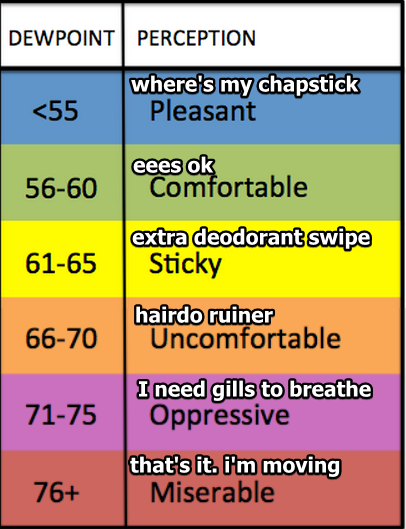
The heat & humidity combo is the bigger deal. Afternoon dewpoints will hover around 70° all week. According to this unofficial chart, we’ll end up somewhere between ruined hairdos and needing fish lungs.

read more

Hot Week Ahead

Current Radar

 Looks like the “hard G” is winning. Gif as in “gift.” I was in the “soft G” camp, until I read this:

https://twitter.com/ctbrewer22/status/754653793049047040 read more

More Rain Coming This Week. When’s It Going to Get HOT?

Current Radar

The Rain Never Came Today

Rain and storms remained stuck near the MS/TN/AL borders. A few showers lifted north toward our air, but those were zapped by drier and more stable air.

We did get a pretty cool roll cloud, though.

Higher Rain Chances on the Way

Rain chances Monday and Tuesday will be higher than the common “summertime pop-up” set ups. Let’s quote NWS!

As the northeast trough lifts out and heights rise, deeper moisture lurking just south of Tennessee will return northward late tonight through Monday. Also, a weak upper trough that has been sitting over north Mississippi will slowly lift north northeastward. These features will combine to spread scattered showers and a few storms across the Mid State on Monday and into Tuesday as well. read more

More Rain? It’s Summer, So....

Current Radar

Sunday – An Area of Light Rain Should Lift North Toward I-40

It’s raining this morning at the Alabama/Tennessee border.

We think that rain will creep north.

The HRRR model illustrates:

Notice how this model lifts what looks like a pretty big blob of light rain through the morning, then by 1 PM, it vanishes. We don’t think it’ll happen exactly like that, but we do think the rain should be decreasing as it comes north. It may not even make it. read more