This will be easy. Expect beautiful weather Sunday (68) and Monday (71).

Rain arrives Tuesday, probably late Tuesday night or Wednesday morning. There’s no severe weather on the horizon.
Enjoy the weekend!

This will be easy. Expect beautiful weather Sunday (68) and Monday (71).
Rain arrives Tuesday, probably late Tuesday night or Wednesday morning. There’s no severe weather on the horizon.
Enjoy the weekend!
Frost Tonight. Not the
Poet. Real frost. Cover plants,
or else they may die.
...FROST ADVISORY IN EFFECT FOR ALL OF MIDDLE TN LATE TONIGHT... .AN UNSEASONABLY COLD AIRMASS WILL BUILD SOUTHEASTWARD TOWARD THE MID STATE OVERNIGHT. AS CLEARING COMMENCES BY LATE THIS AFTERNOON AND EVENING...THE STAGE WILL BE SET FOR GOOD RADIATIONAL COOLING TONIGHT. WITH ENOUGH SURFACE MOISTURE REMAINING IN THE LOWEST LEVELS...THE POTENTIAL FOR FROST DEVELOPMENT EXISTS...PARTICULARLY IN LOW LYING AREAS.
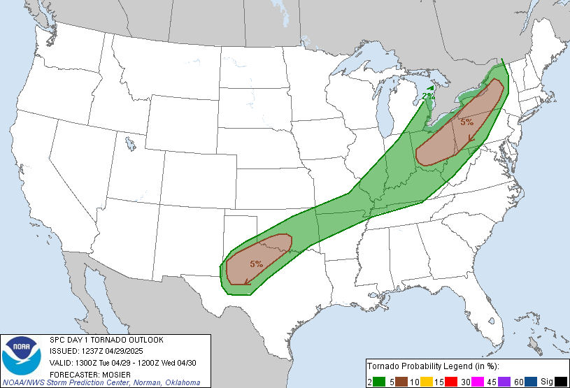
Tonight the Storm Prediction Center removed all of Davidson County and some of Williamson County from its Slight Risk (of severe weather) outlook. Only south Williamson County is hanging on:

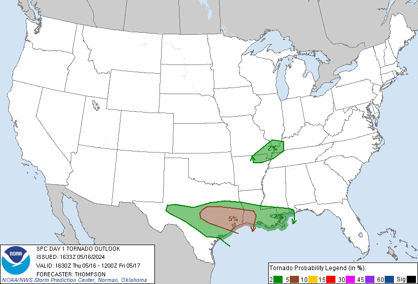
There’s only a fringe chance of a tornado tonight: a 2% probability of a tornado happening within 25 miles of those in Williamson County:
Noon weather balloon data from Nashville and surrounding NWS offices showed a real, but lessening, severe weather threat for tonight.
The squall line nearing the Mississippi River continues to underwhelm – very few warnings on the line at all, and none (as of this writing ~ 3pm) on the segment of the line heading into Tennessee.
Just got off the phone with the NWS.
At 1pm, the squall line was in Little Rock, moving slowly east through central Arkansas toward the Mississippi River. Central and east Arkansas is under a Tornado Watch.
A Wind Advisory is in effect until 1am tomorrow. Winds may gust 40-50 mph late this afternoon, and then again just before the squall line approaches.
Anytime between 11pm and 3am. Best guess remains midnight.

The NWS says tornadoes can’t be ruled out. Tornadoes may be
You won’t be able to see any tornado tonight, so don’t try and go outside to have a look.
We are remain on the edge between the “hatched” area (shaded) and the non-hatched area. The percentages (10% and 5%) represent the probability a tornado will occur within 25 miles of anyone inside that area. The hatched area means there is a 10% or greater probability of an EF2 – EF5 (110mph to 234mph winds) tornado happening within 25 miles of anyone inside that area.
We remain outside of, yet uncomfortably close to, the hatched area.
This afternoon, our NWS emphasized that non-tornado damaging straight-line winds remain the biggest threat.
The probability of damaging winds at or above 58 mph is between 30% and 45%. We’re right on the line. Tie down anything you don’t want blown off your property.
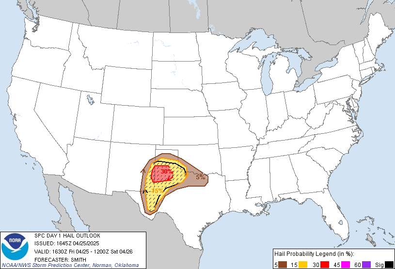
The probability of hail > 1″ occurring within 25 miles of you is between 5% and 15%. Again, we are right on the line.
I would feel a lot better about these storms if we were 50 miles east of I-65. Storms are forecast to begin weakening at I-65. Pinpointing a 40 mile range when severe storms may weaken is a near-impossible task. That said, the models suggest some weakening will occur.
For example, here’s the WRF model our NWS likes (due to its decent track record). It likes the storms to weaken:
1 am:

By 4 am, notice how the storm intensity has backed way off:

1″ to 2″ possible. The rain should be long gone Friday by lunch.

Temps will fall dramatically. Here’s what the NWS said this morning:
MUCH COOLER TEMPERATURES ARE ANTICIPATED FRIDAY AND SATURDAY WITH LOWS FALLING INTO THE MID TO UPPER 30S SATURDAY MORNING. WITH SURFACE RIDGE SETTLING OVER THE MID STATE...LIGHT TO CALM WINDS...AND DEWPOINTS FALLING INTO THE 20S AND 30S...PATCHY FROST APPEARS POSSIBLE FOR MUCH OF THE FORECAST AREA AND HAVE ADDED MENTION TO ZONES.
A powerful storm system is approaching. It’ll be here tonight. Here are all the details. We’ll have more details this afternoon.
Yesterday, a cold front dragged itself across the then-humid Plains. A squall line formed, which dropped numerous funnel clouds, two tornadoes, +/- 40 reports of winds > 58 mph, and around 100 reports of hail > 1″ (not all of yesterday’s storm reports were associated with the line). Here’s what happened yesterday:

This system is coming our way. This morning it was moving out of west Arkansas into central Arkansas.
This morning our NWS issued a Wind Advisory, effective from 10am today until 1am tomorrow. Winds may gust to 40 mph as the squall line approaches.
The Storm Prediction Center has five “risk” products: (1) No Risk – (2) General Thunderstorm Risk – (3) Slight Risk of Severe Wx – (4) Moderate Risk of Severe Wx – (5) High Risk of Severe Wx. We see a handful of Slight Risk days every year. We may get 2 or 3 Moderate Risk days a year. Some years we don’t get any. High Risk days are exceptionally rare.
Today, the Moderate Risk line runs almost exactly down I-65:
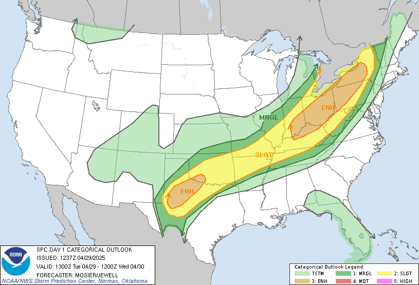
Don’t get caught up too much in whether the edge of the Moderate Risk area is 20 miles this way or that way. Although we are on the edge of the area — we are downstream of it. Those storms are coming our way, hopefully weaker upon arrival.
Check out this SPC map:
We are right on the edge between the “hatched” area (shaded) and the non-hatched area. The percentages (10% and 5%) represent the probability a tornado will occur within 25 miles of anyone inside that area. The hatched area means there is a 10% or greater probability of an EF2-EF5 (110mph to 234mph winds) tornado happening within 25 miles of anyone inside that area. We are uncomfortably close to that hatched area.
Anyone planning to drive to or from Memphis tonight should staple themselves to reliable weather sources.
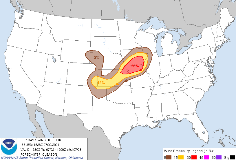
Non-tornado damaging winds > 58 mph are our greatest threat:
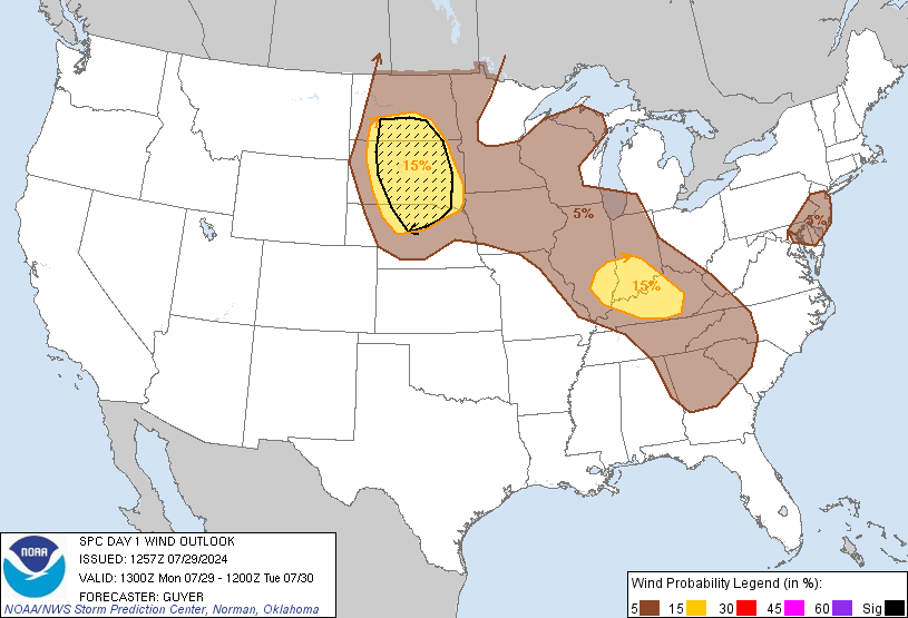
The probability of damaging winds at or above 58 mph is between 30% and 45%. We’re right on the line. Tie down wanted garden gnomes, secure deck umbrellas, just-planted trees, etc.
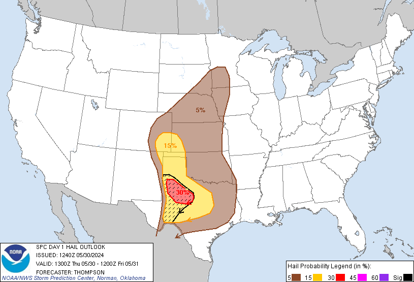
The probability of hail > 1″ occurring within 25 miles of you is between 5% and 15%. Again, we are right on the line.
The high instability and impressive shear forecast to fuel the storms in W Tennessee is expected to weaken a bit beginning at and east of I-65. There is not total model agreement on that:
SOME GUIDANCE INDICATES A SURGE OF MID/UPPER 60S DEWPOINTS
COMING NORTHWARD AHEAD OF THE [SQUALL LINE] WHICH COULD BUMP UP
[INSTABILITY] VALUES TO NEAR/OVER 1000 J/KG ACROSS WESTERN ZONES.
Do not discount the threat. Again, from our NWS office:
REGARDLESS...IMPRESSIVE 0-3KM [SPIN IN THE ATMOSPHERE] STRENGTHENING INTO THE 500-800 M2/S2 RANGE [THAT'S A LOT} AND VERY LONG CURVED HODOGRAPHS SUGGEST A SIGNIFICANT DAMAGING WIND THREAT WITH THE LINE OF STORMS ALONG WITH SOME [SQUALL LINE] TORNADOES. HIGHEST RISK OF DAMAGING WINDS/TORNADOES IS EXPECTED TO BE ALONG/WEST OF I-65 IN THE [9PM-1AM] TIMEFRAME ACROSS THE MODERATE RISK AREA...AS STORMS WILL ENCOUNTER INCREASINGLY LESS INSTABILITY AND WEAKENING SHEAR OFF TO THE EAST.
We will have hit-or-miss showers tonight. Don’t cancel outdoor plans. If you’re unlucky enough to be in the “hit” rather than the “miss,” consult your rabbi, pastor, minister, life coach, mentor, etc.
An impressive swath of severe weather, now forming in the Plains, is forecast to move east tomorrow through Arkansas toward Middle Tennessee. This has prompted SPC to issue a Moderate Risk of severe weather for West Tennessee (see below). This is a dangerous weather situation. Anyone traveling to Memphis tomorrow should staple yourself to reliable weather sources. On Twitter, there’s no better source for Memphis & surrounding counties than @memphisweather1.

We are currently excluded from the Moderate Risk area. We’re encircled by the Slight Risk, mostly because the storms are expected to arrive around or after midnight Thursday night into Friday morning. This wee-hour arrival should – we think and hope – decrease our storm potential. This is a storm system worth closely watching. Here are excerpts from the NWS:
BY THE TIME THE LINE REACHES NASHVILLE...TENTATIVELY
AROUND MIDNIGHT...IT WILL BE MOVING INTO MORE STABLE AIR
AND THE SEVERE WEATHER THREAT WILL CONTINUE TO WEAKEN AS
IT MOVES EAST.
That said:
THE JET DOES REMAIN STRONG MAINLY OVER KY AND NORTHERN MIDDLE TN AS THE LINE PUSHES EAST. HELICITY VALUES AND FORECAST HODOGRAPHS ARE STILL IMPRESSIVE AND COULD ENCOURAGE SOME SPIN UPS RIGHT ALONG THE BOUNDARY...THIS THREAT WILL ALSO BE MAINLY WEST OF THE INTERSTATE 65 CORRIDOR WHERE THE BEST INSTABILITY OCCURS. SHOWERS SHOULD EXIT THE AREA BY THE AFTERNOON HOURS ON FRIDAY.
The Storm Prediction Center has encircled middle Tennessee inside a Slight Risk of severe weather today:

The main concern is wind > 58mph and hail > 1″. There’s a 15% of either/both happening within 25 miles of you today. Here are the wind and hail outlooks:
Expect a slight chance of a shower or thunderstorm. We’ll make it into the 80s this afternoon.
This morning, the Storm Prediction Center included us within a Slight Risk of severe weather for Thursday overnight into Friday morning.

We should stay dry most of the day Thursday — and get in a rare [insert sport here] practice/game Thursday evening — but it will be very windy. Our NWS explains:
THUS EXPECTING STRONG SOUTH WINDS AT THE SURFACE BY AFTERNOON
WITH GUSTS UP TO 40 MPH AT TIMES...AND A WIND ADVISORY WILL
LIKELY BE NECESSARY.
Our NWS says the weather models are in “great agreement” (unlike last week) that a squall line will form to our west Thursday night, reach the Tennessee River around 10-11pm, and hit us around 1am.
Damaging winds are the main concern. We may see a few tornadoes inside the squall line. The good news is the storms should begin to weaken right around the time they get to us. Here’s the NWS explanation:
STRENGTH OF SHEAR AND OVERALL SYSTEM INDICATES POTENTIAL FOR DAMAGING WINDS AND POSSIBLY A FEW ISOLATED QLCS TORNADOES ACROSS THE WESTERN HALF OF THE MID STATE...BEFORE ACTIVITY WEAKENS NEAR/EAST OF THE I-65 CORRIDOR AS IT OUTRUNS WHAT LITTLE INSTABILITY REMAINS.
We may see thunderstorms Wednesday afternoon, but right now we don’t think those will be severe.
The high Wednesday is 84, and we’ll make it to 83 Thursday. Friday’s high is only 61 – that’s 22 degrees colder.
You must be logged in to post a comment.