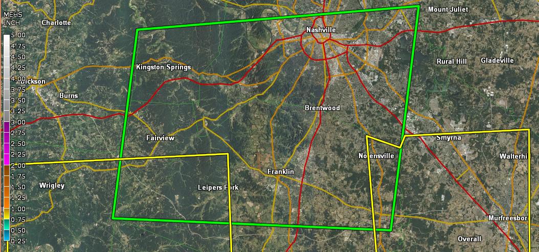
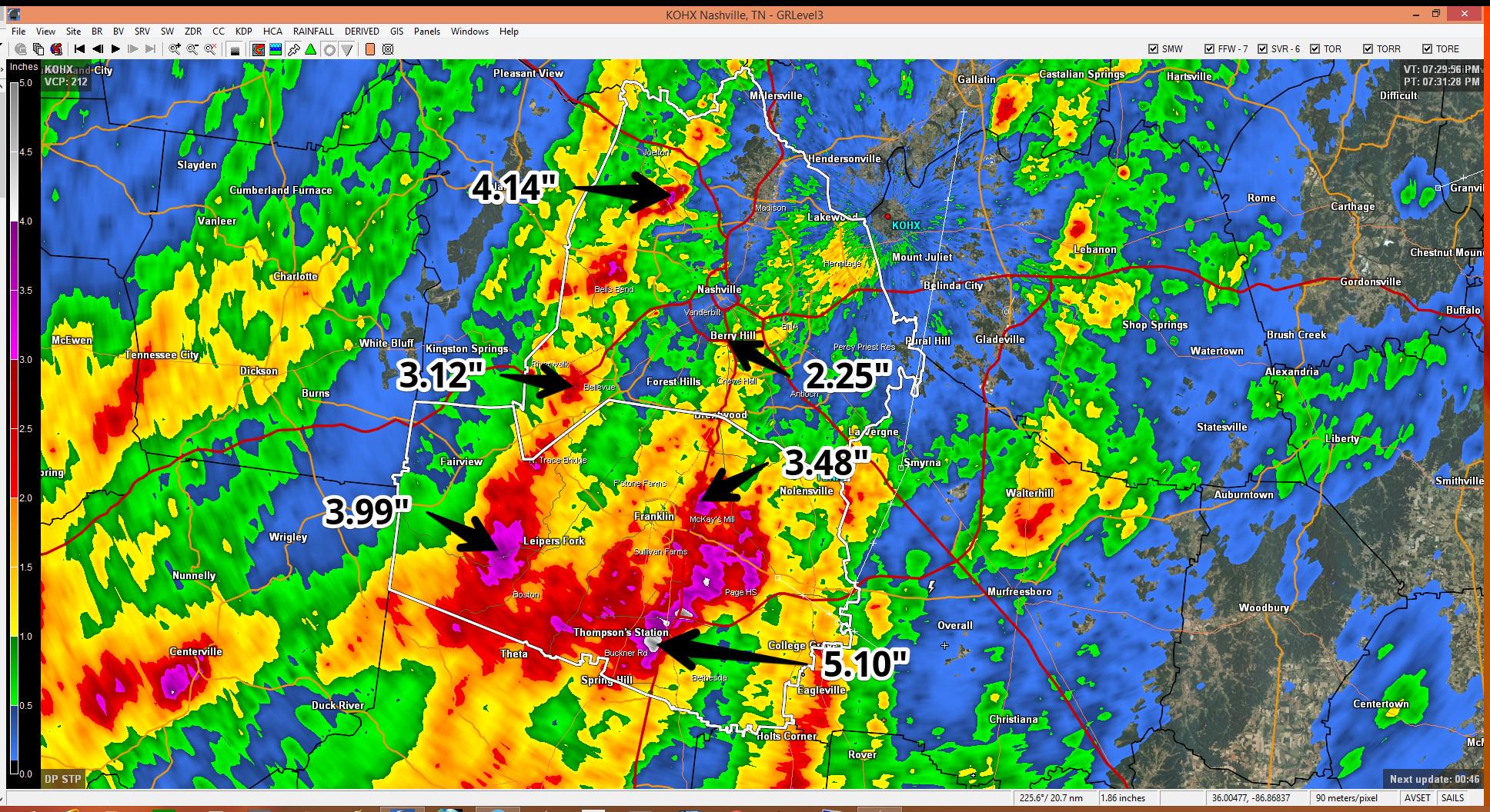
This Weekend, We Bake

Current Radar

Tonight – Watching To See If/Where It’ll Rain 

This is the classic Nashville summertime pattern. Gets hot, it’s already humid, and downpours pop up afternoon, last into the early evening, then die off. This happened close to and just south of downtown, in Thompson’s Station/Franklin, and between Brentwood and Nolensville. None of them were little sprinklers, but they barely moved, and collapsed after a few hours. Where will they be today? read more

Clearing Out

Current Radar

Overnight – Few Lingering Showers

Well, that was exciting. Lots of lightning, torrential rain, and big hail. This was from @AshleyCB84:

A Flash Flood Warning remains effective until 8 PM inside the green polygon:

The bad storms are gone; however, a few small showers currently to our NW may still work through tonight. read more

Today: Hottest Day Of The Year; Monday: PM Severe Storms Possible

Current Radar

Sunday – Hottest Day of the Year – High 93°

Dewpoints are also creeping toward the mid-60°s, so it’ll start getting humid, too.

Still no meaningful chance of rain during the day.

Tonight, we may see a shower squeeze out north of 40, but that looks unlikely. It’s just hard to completely rule out rain when temps go this high with this much moisture in the air. read more

A Great Summer Weekend; Stormy Monday; Stuff You Need for CMA Fest

Current Radar

Saturday Night – Gently Cooling Off 

We don’t think it will rain. Do not alter any outdoor plans. If you picked today as your wedding day, you’ve won the summertime forecast lottery. It’ll be hot, but that light north breeze will be nice. read more

Flood Concerns

Current Radar

Tonight – Flooding Concerns

We’ve seen a LOT of rain. I thought we would shake it. We haven’t.

Through 7:30 PM

An Areal Flood Warning, although recently cancelled for Davidson Co, is effective for Williamson County until 10:15 PM. read more

One More Day Of This Junk

Current Radar

Tonight and Sunday – Rain/Storms Hanging Around – High 82°

Shower and thunderstorm chances will continue through the overnight hours tonight into Sunday morning. The potential for severe thunderstorms (damaging winds, not hail or a tornado) will continue during this time, but it’s rather unimpressive. Without some sun-fueled heating, they’ll struggle to mature. read more

Dodgeball

It’s dodgeball time!

Tonight – Maybe Some Showers and Weak Thunderstorms 

It may rain today and through the weekend. In fact, we think it will rain, but when and where, we don’t really know. Tonight and tomorrow’s weather is without an obvious focal point to initiate showers and storms, hence the uncertainty. If you want meaningless quantification and LOL ETAs, please consult a wide array of crap apps. We would rather embrace uncertainty with honesty, than guess and hope we hit the lottery so you think we are super geniuses). read more

Brief Review of Today’s Severe Thunderstorm; Rainy/Stormy Pattern Continues

Current Temps and Radar

Tonight – Things Settle Down

So, we had a severe thunderstorm today. Here’s the polygon with the radar turned off so you can see the blobby stuff, which is where we think all the hail fell: read more

Rain is Gone (for today); Heat and Humidity Stay

Current Temps and Radar

Tonight – Rain Gone, Still Humid 

After a lot of rain early this afternoon (officially 0.63″ at the airport), we should be relatively dry tonight. “Little if any [rain] redevelopment is expected,” says our NWS. read more

Rain, With Severe Weather Possible, Today

Tuesday – Rain & Possibly-Severe Thunderstorms – High 81°

Another round of extensive showers and storms will spread eastward out of the Plains into Middle Tennessee. Because weather models differ significantly on the timing of the rain/storms, there is a lot of uncertainty on how strong the storms will be. read more