Higher Rain Chances Thursday

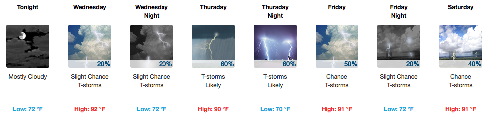
Few More Storms This Evening

A couple more pop-up showers/storms are possible this evening but should be gone shortly after sunset. If you get underneath one of these, the temperature will likely drop about 5-10 degrees.

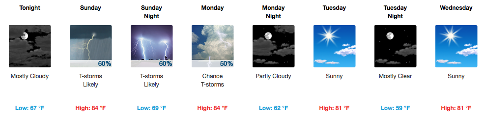
Rain Storm Coverage Increasing Thursday and Beyond

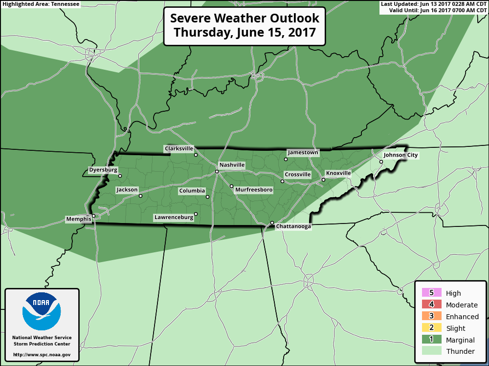
The Storm Prediction Center has placed all of Davidson/Williamson counties under a “Marginal Risk” for severe weather on Thursday. Marginal hail and wind gusts are the main threats with any storms that get going. There will likely be better coverage of rain, so the umbrella would be more useful Thursday than with these other pop-up PM storms. read more

Feeling “Red Hot” Today, Zero “Chance” of Rain

A lot of big names are playing today/tonight at bonnaroo and the weather really couldn’t be much better for this time of year. It will be warm and *slightly* more humid than Thursday and Friday, but overall, it’s another great day for festival-goers. read more

Gradually Warming Up, Rain Possible This Week

Air Quality Alert Until Midnight

Getting Hotter, A Tad More Humid Today

Abundant sunshine will help to warm our afternoon temperatures into the upper 80s today. A return of southerly winds will increase our humidity ever so slightly, definitely becoming more noticeable by tomorrow. We will be in the “eees ok” category today, based on the dew point table below: read more

Coolest Today, Warmest On Sunday

A gradual uptick in temperatures and humidity will most notably be evident on Sunday of all days this weekend. For a majority of the festival, afternoon highs will be in the 80s, except for an official high of 90ºF 0n Sunday. read more

Celebrating Music, Hockey, and Great Weather

[av_textblock av_uid=’av-wd3lni’]
[cjtoolbox name=’Testing HTML 1′]
[/av_textblock]

Big Day For Nashville, Very Comfortable Conditions

Being probably the “pick day of the week”, today is and already has provided gorgeous weather conditions. A north wind continues to filter in cooler air for one more day, keeping our high temperatures down in the mid 70s! read more

Sunny Days Are On The Way!

Weekend Starts Early With CMA Fest — Weather Looks Awesome

The string of the next 5 days looks spectacular. Temperatures and dew points stay low and bearable, especially Wednesday and Thursday. Temps will creep up as we get into Saturday and Sunday, approaching 90ºF for afternoon highs. As long as you’ve got sunscreen, maybe some cool sunglasses/hat, and some water to keep hydrated, CMA Fest weather will treat you very nicely this year. read more

bonnaroo looking great weather-wise!

We’re looking to be in really good shape for Thursday-Sunday. Temperatures will start Thursday-Friday in the low to mid 80s, creeping up towards 90ºF by Saturday and Sunday. Humidity will also increase a bit by the weekend. read more

Stormy Sunday PM and Monday AM

Clouds Increasing, Dry Evening

Clouds will start to push in this evening, and temperatures will fall into the lower 80s/upper 70s by 9PM.

[av_textblock av_uid=’av-lkhyzb’]
[cjtoolbox name=’Testing HTML 1′]
[/av_textblock] read more

Slightly Better PM Storm Chance Today

Afternoon Storm Chances Through Next Week

UPDATE: There are a few thunderstorms sagging southward towards Davidson County. Will these make it here? Time will tell. They are taking their sweet time. We’ll be following their progression, and post-sunset dissipation on Twitter @NashSevereWx. read more

Rainy Weekend Expected

Wednesday’s Front = Rain/Storm Potential

Showers and a few storms are expected once again on Wednesday as a frontal boundary approaches middle Tennessee. The GFS paints a picture of rain while the NAM is very shy on placing any rainfall over our area. NWS Nashville is leaning towards the chance for rain rather than not at all, and some of these showers/storms could contain gusty winds and small hail. read more