Today is the official start of summer for us (and everyone else in the Northern Hemisphere), and the forecast certainly looks like it.
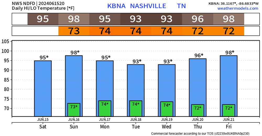
High temperatures in the mid to upper 90s for at least the next 6 days will be a brutal stretch.

Today is the official start of summer for us (and everyone else in the Northern Hemisphere), and the forecast certainly looks like it.
High temperatures in the mid to upper 90s for at least the next 6 days will be a brutal stretch.

While this isn’t a forecast blog, this is a look ahead to something coming soon!
David, Will and I remember the days, not so long ago, when we were financially supporting NashSevereWx out of our own pockets. Granted, we didn’t have as many ongoing costs as we do now. But, being weather twitterers was a sandbox we wanted to play in, and our families were gracious enough to humor us (and still do).
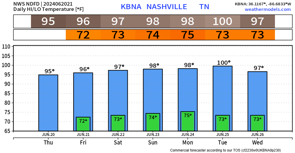
Summer will officially begin tomorrow and there will be no doubt about it.
Today is the coolest day in the forecast – rest of the forecast holds high temperatures in the mid to upper 90s. Saturday and Sunday we’ll be flirting with 100°.
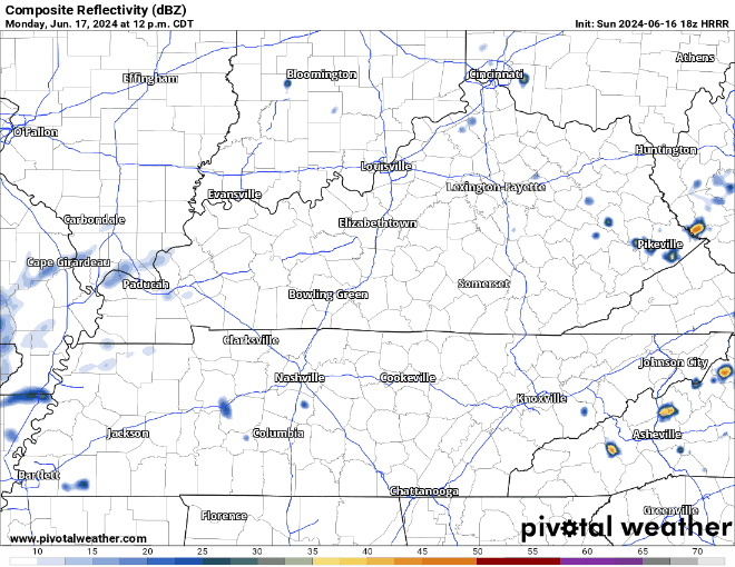
Although there are still some Wattery winners today, fewer tickets have been chosen. Similar to past days, any “winner” could see some brief heavy rain, lightning and gusty winds. These storms tend to fall apart just as fast as they pop up, but a quick inch or so of rain is possible.

A few Wattery winners have already been chosen today, and a few more will be announced tomorrow, although chances look lower.
With any storm today or tomorrow, brief heavy rain, lightning and gusty winds will all be possible. A quick inch or so of rain is possible, while your friend on the other side of town gets nada.
Several of us have seen rain thus far this afternoon, a few have even seen some downed trees – thanks to a downburst.
Tree damage + power outages – not cool. However, the rain has taken the heat index from 105° to the upper 80s at BNA.
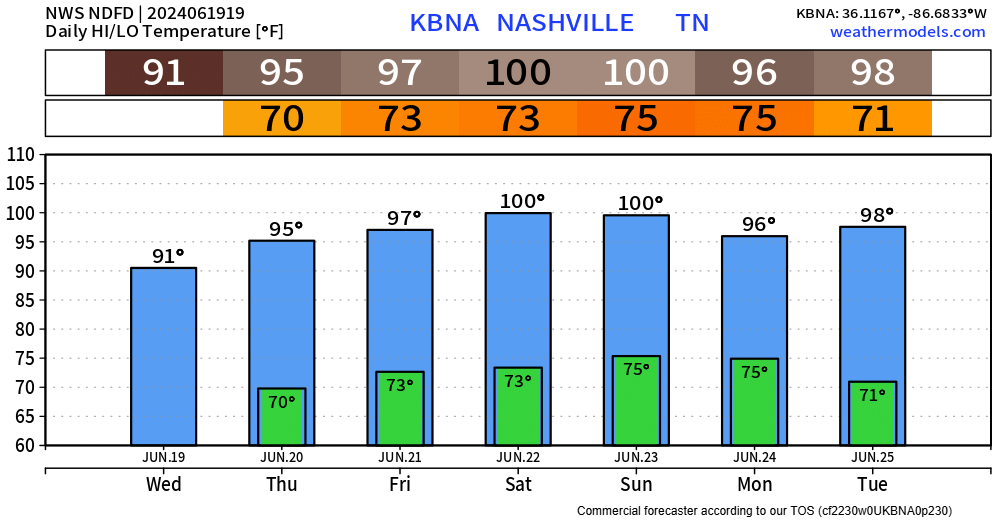
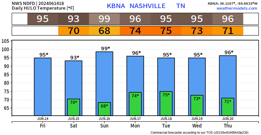
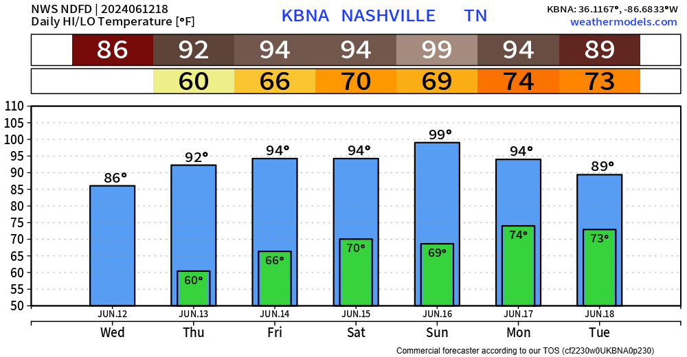
Today we’ve experienced one of, if not the hottest day thus far this year. Thankfully, dewpoints in the low 60s have kept the heat index right near the actual air temperature.
These hot temperatures aren’t going anywhere, with high temps in the 90s thru the remainder of the forecast.
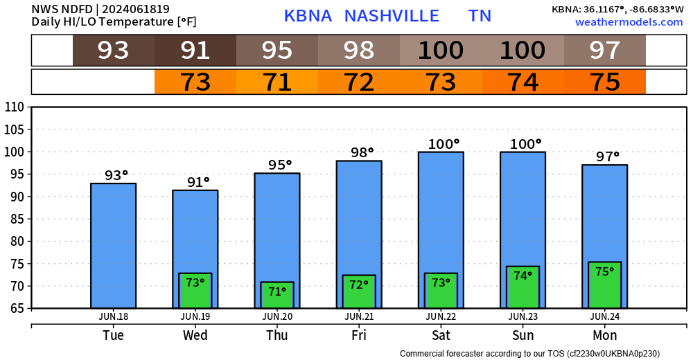
Although it is a dry weekend, it sure is a hot one.
Today and Saturday will be hot, but the heat index won’t differ too much from the actual air temperature.
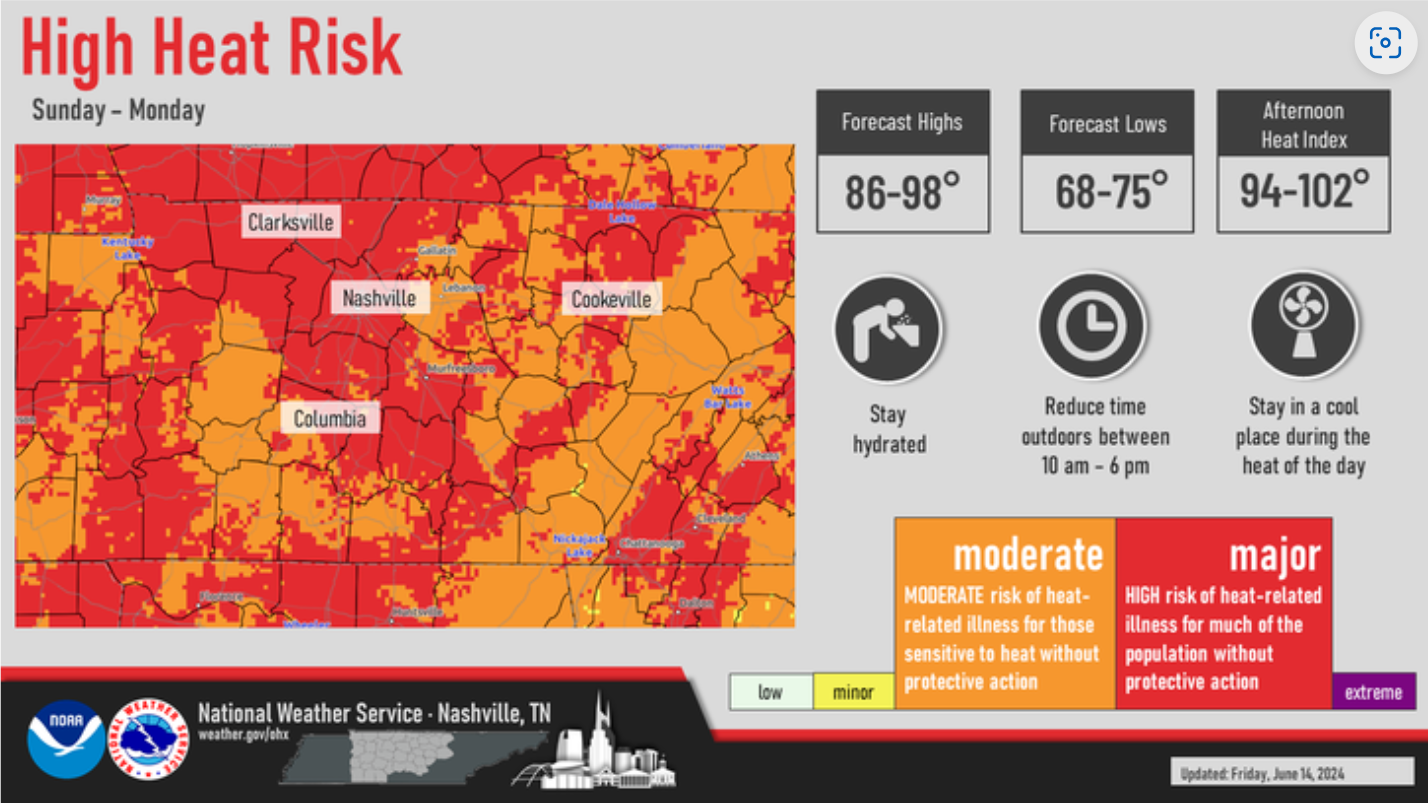
Sunday and Monday will be the hottest. Dewpoints will creep up, allowing for the heat index to surpass 100°. If you have to be outside either of those days, take it easy. Take frequent breaks in the shade and/or A/C.
Monday seems to be our only day with rain chances in the forecast, but those chances are low.
"Monday will be Middle TN`s best shot
at getting some rain in this forecast package. Unfortunately, it`s
still not a great shot. Will maintain a 20-30% chance, however, if
you get a storm on Monday afternoon, expect brief heavy rainfall,
lots of lightning and even the potential for some gusty winds." - NWS Nashville AFD
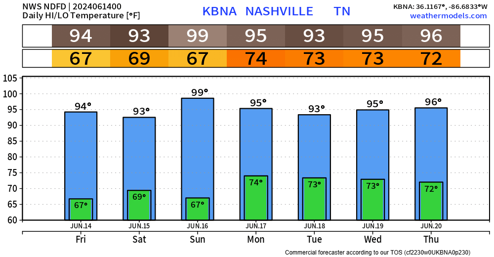
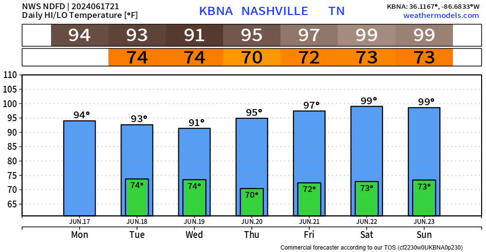
90s as far as the eye can see…
The humidity could be nicer, but it could also be worse. Dewpoints in the mid to upper 60s will make ya sweat faster.
Peak heat will be Sunday (sorry dads), with high temperatures flirting with the 100° mark, but models think we fall just short. Regardless, heat index values may exceed 100°. Only a little better for days not named Sunday, heat index values in the upper 90s still possible.
Today is the last day to get any outside yardwork done, at least in somewhat comfortable weather, for the foreseeable future.
Dewpoints in the 50s today, turn up into the mid 60s tomorrow, upper 60s by the weekend. Grosssssss.
You must be logged in to post a comment.