Search Results for:
Rainy & Cooler Weather Continues: Wet Fourth?
Rest of Monday – High 84; Scattered Thunderstorms
Thunderstorms have been weaving in and out of the area all afternoon, thanks to a meandering low pressure system that will be hanging around the next few days. Even though most of the storm activity is to our east, there still could be some storms well after sunset. We may also see some patchy fog late tonight.
Next Several Days: Cool & A Little Rainy
Unsettled Weather, Below Normal Temps Next Several Days
Next Several Days
A low pressure center at 500 mb (that’s at 18,000 feet) will wander south from the Great Lakes, then spin around through the 4th of July. See the below (patriotic) loop from June 29 through July 7. The low pressure is red. This will “unsettle” our weather through the 4th.

Our NWS says:
THIS DOESNT MEAN IT IS GOING
TO RAIN EVERY MINUTE OF EVERY
HOUR BUT THERE WILL BE AN ON-
GOING CHANCE FOR SHOWERS AND
A FEW THUNDERSTORMS ON A
DAILY BASIS.
They continue:
EVEN AFTER UPPER LOW LIFTS NORTHWARD INTO CANADA AROUND JULY 4TH WE HAVE SUCH A GOOD MOISTURE FEED FROM THE GULF OF MEXICO INTO THE TENNESSEE VALLEY THANKS TO A RATHER STRONG BERMUDA HIGH KEEPING THE CHANCE OF SHOWERS AND THUNDERSTORMS.
Cool, Pleasant Weekend; Rain Possible Sunday
One More Hot Day; Unseasonably Cool Temps Arrive This Weekend
Stormy Friday Morning Possible; Better Weekend!
Update on Tonight’s Damaging Wind/Hail/Tornado Threat. Midnight ETA
Afternoon Update: Details on Tonight’s Wind/Hail/Tornado Risk
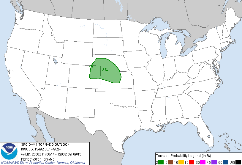
The 3 p.m. update from the Storm Prediction Center was largely unchanged for us. The probabilities of “x” happening within 25 miles of you today:
- Damaging Winds (58mph+): 30%
- Large Hail (1″+): 15%
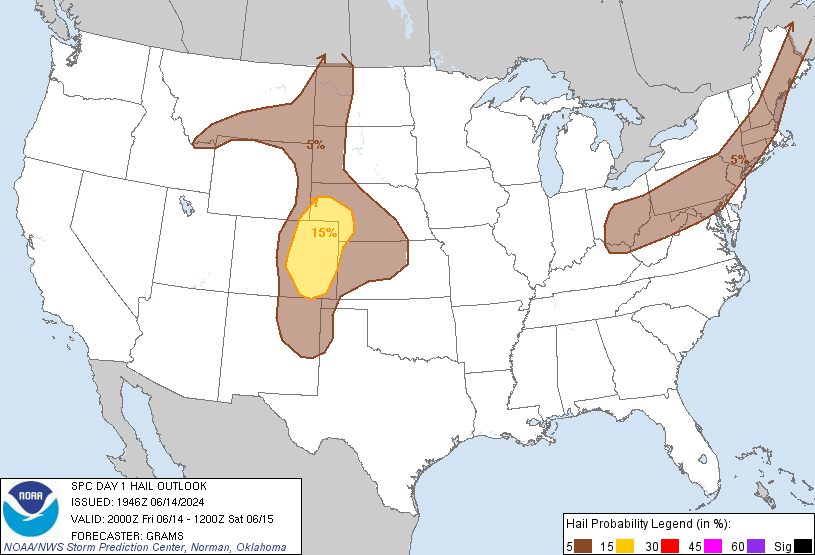
- Tornado: 2%:
Afternoon thunderstorms (previously advertised as “Round 1”) haven’t developed as predicted by weather models, likely due to a “cap” up in the atmosphere preventing a large amount of thunderstorm energy from being released. Also limiting afternoon thunderstorms has been some “mixing,” causing drier dewpoints to come on down . . .