
The story of NashSevereWx began in 2010…on Twitter. In 2011, we had 100 followers. Twitter has been our home. It’s the best way to get information to you in a chronological fashion and for you to get information to us. We’ve become efficient in our process of communication on Twitter. It has worked well.
NashSevereWx and Twitter
Cold Continues, Drought Eases Somewhat
Let’s start with the good news. The latest US Drought Monitor map (released today) has removed the area of severe drought from both counties. We got downgraded to moderate drought. Hopefully soil moisture and drought impacts can improve greatly over the winter. We’re not there yet, but heading in the right direction.
Cold and Dry Through the Weekend

Winter-lovers rejoice. Your time has come.
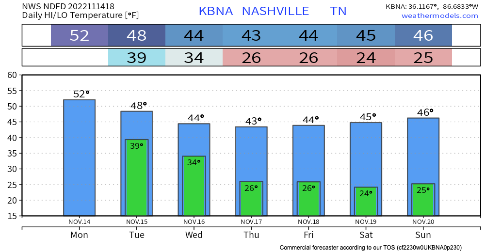
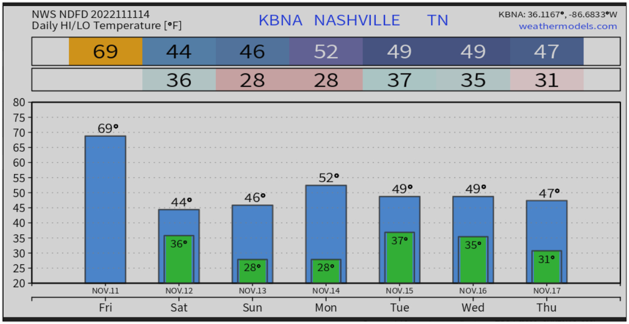
Temps will be running well short of our average high of 60° for this time of year. In fact, we don’t make it out of the 40s for highs until Monday. Should have plenty of sunshine though. Lows will generally be in the mid-20s.
Hey Alaska. Come get your weather.
- The average high for Nashville today is 60°. If only.
- Rain has moved out (save for a few sprinkles or some drizzle).
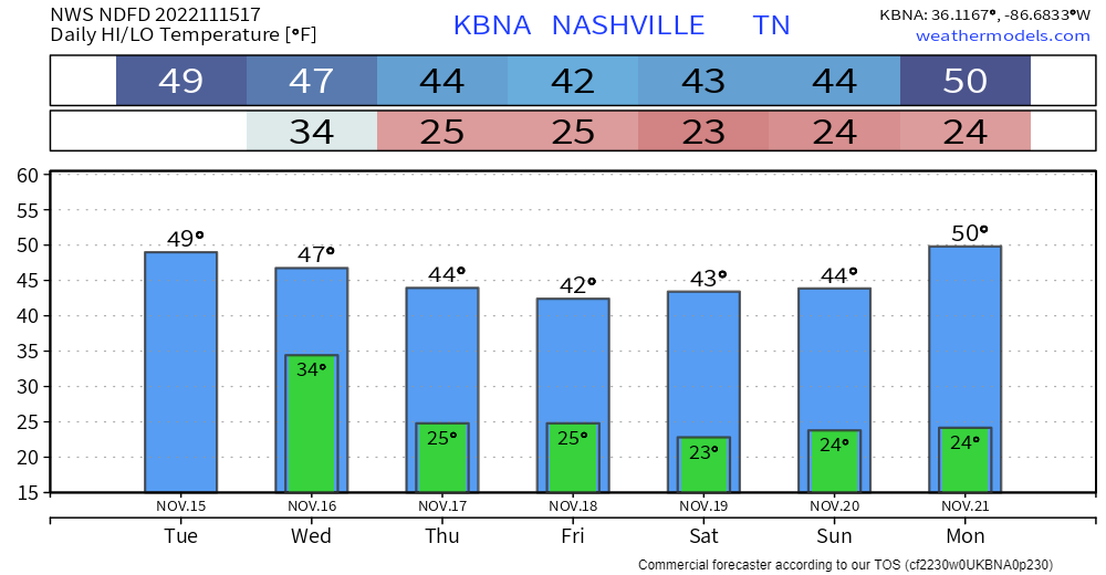
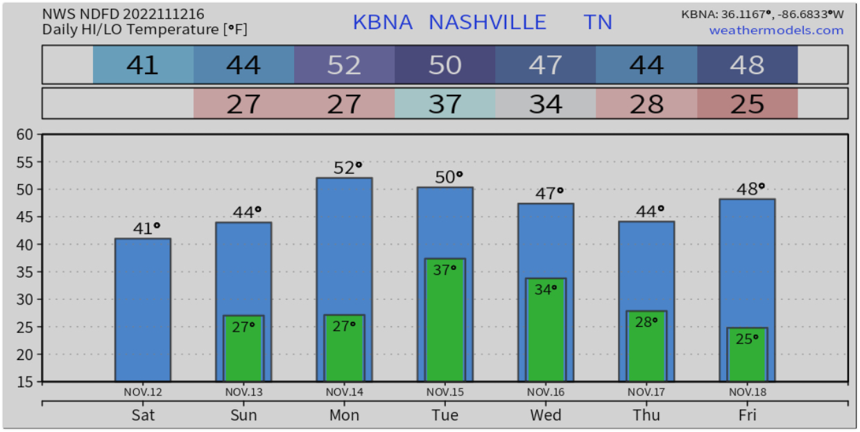
- There’s really only one story this week, and that is the continuing cold weather, especially late week. Thursday through Sunday temps probably won’t get above 45°, again, roughly 20° below normal.
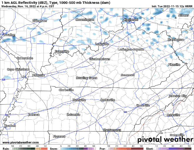
- We could get a passing flurry Wednesday night, according to the HRRR. No big deal. Loop 4 pm through 1 am Wednesday/Thursday.
Quick References:
Weather changes constantly.
Follow @NashSevereWx on Twitter for any changes to this forecast.
Live coverage during tornado and severe thunderstorm warnings.

Look good.
Support the mission.
Rain Tonight; Cold Weather Continues
Sun today will give way to unsettled weather tonight. Rain should enter the area around 10:00 pm and continue overnight, ending around lunchtime Tuesday. 12z HRRR:
No severe weather or flooding concerns with this system…just a cold rain…about a third of an inch should be common,.
A Typical Fall/Winter Week Ahead

Oscillating between cold and colder and grey skies and sun is pretty typical for us this time of year.
The warmer temps we’ve felt the last few weeks are a distant memory when you walk out the door today. The cold has set in. We’ll have plenty of sun today, but temps will struggle to make it into the mid 40s thanks to a stiff wind from the NW. At least it isn’t Blerg.
Cold and Wet
Today… Blerg again. It’s our official unofficial term for Temps below 40 with no sun. That’s us today.

We had 70s on Thursday and 60s yesterday. Today and tomorrow we’ll struggle to get into the 40s. Sun will return tomorrow but evening temps will be below freezing.
Blerg Watch For Saturday, Cold Temps Settling In

Get outside while you can, it likely won’t be this warm again for a hot minute.
As a cold front pushes in later this evening, it brings colder temps along with some rain chances, along with a chance at a term that hasn’t been used in a while – Blerg.
Rain, Sun, Rain, Sun, Cold
In this blog we’ll cover two different weather stories. The rain, and the temps.
Precipitation
We woke to water falling from the sky. As of posting this, we’ve gotten more than an inch of rain at BNA. We have a bit more rain left this morning before it moves east and the sun comes out. Below is the HRRR through 1pm Friday.
Rain, Then Brrrr

The forecast has remained pretty consistent over the last few days. The two stories from the last couple of days remain the two stories for today.
Rain Tonight Into Tomorrow Morning
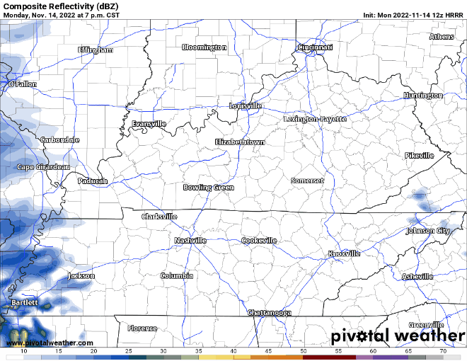
We’ll be affected by two systems. The remnants of Nicole from our east. A strong cold front from our west. As these two systems interact, we expect rain to begin overnight and last until tomorrow afternoon. HRRR loop 4:00 pm today – 7:00 pm Friday.
You must be logged in to post a comment.