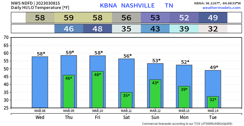
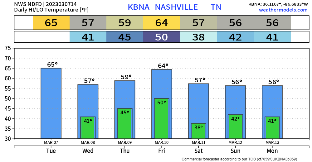
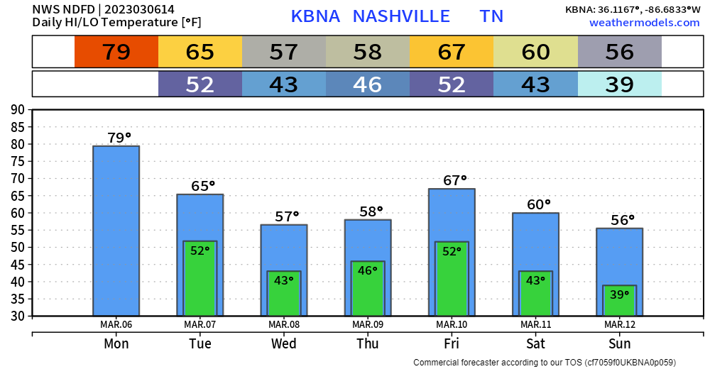
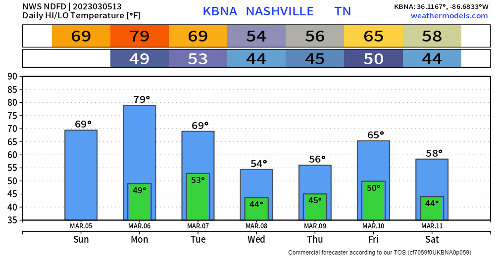
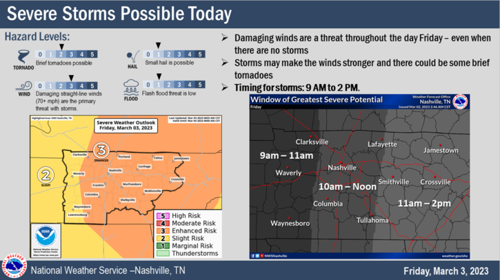
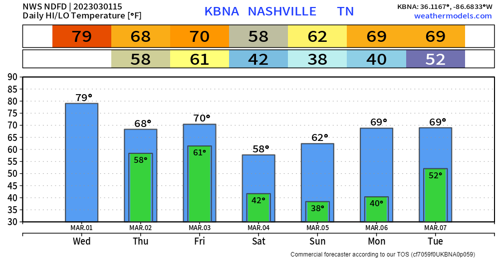
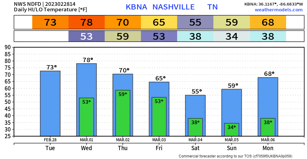
The temperature graph above lacks fun colors, and that’s because we will be lacking fun temperatures for at least the next week (probably longer). We’ll take a break from the 70’s and 60’s, and settle down to cooler temperatures, which, we’ll really be where we ought to be this time of the year. We’ve been getting spoiled with warm temperatures, back to reality.
Category: Forecast Blogs (Legacy)
Rainy + Cooler End of the Week
Beware of False Spring, Rain + Cooler Temps Returns Wednesday
It’s March, temps have been/are in the 70’s, even pushing 80° today, could it be…an early arrival of Spring??
No.
Veterans will know this happens pretty much every year, around the same time. False Spring. And then a blast of cooler temps likes to come smack you in the face to remind you, that just because it is meteorological spring, does not mean it is astronomical spring.
Dry + Warm Start to the Week, Opposite Ending
Today – Tuesday will be great for any and all outdoor activity. You may even break a sweat tomorrow with high temps pushing 80°. No rain.
Wednesday afternoon/evening rain chances increase, and they’ll stick around for the rest of the week. Rainfall totals Wednesday thru Saturday look to be around 1.5″, although that number may (probably will) change as we get closer.
‘Twas A Bit Less Windy Today, Rain-Free Til Wednesday

As they say, some of the prettiest weather occurs after a significant storm, and that we had.
Yesterday’s thunderstorms ended up not really being the main story. While there was wind damage associated with the storms themselves, we made it out without any tornadoes locally. Most of the wind damage of the day came after the storms departed and unfortunately, claimed a couple of lives here in Middle Tennessee. That’s news we certainly hated to hear.
Tornado Watch Until 1pm Today, High Wind Warning Until 6pm Today
Before we even dive into the severe threat, we seriously need to talk about this High Wind Warning. This is NOT your typical Wind Advisory that knocks your trash can down. This wind will take your trash can and trampoline down the street. Sustained winds of 25-35mph and gusts up to 60(!!)mph will be possible OUTSIDE of the thunderstorms. It can not be raining and the winds can gust to 60mph. These winds will down trees and power lines. It is important to keep your phone charge and make sure new batteries are in your weather radio so you can receive warnings if any are issued later today. Again, these winds will be OUTSIDE of the thunderstorms and it will be this windy before AND after the main line has passed.
Rain Later Today; Severe Weather Threat Friday AM, High Wind Warning
Cloudy, but mostly dry during the daytime hours today.

HRRR model, above, shows rain moving in around 7 or 8pm tonight, lasting on and off throughout the night. We aren’t concerned about severe weather with this round. The rain will be brought by a warm front, which will set us up for our severe weather tomorrow.
Three(?) Rounds of Severe Weather Possible Tonight Thru Friday AM
Three Chances Of Severe Weather; Wednesday PM, Thursday PM, Friday AM
Rain Clearing Out, Windy Monday, Wet End of the Week
On and off showers will continue for just a few more hours, clearing out around noon or so. You can always check the radar on our website here: Radar – Nashville Severe Weather
We’re still under a Wind Advisory until 6pm today. Sustained winds of 20-30mph, with gusts up to 45mph will be possible. Secure any outdoor decorations/furniture that you care about.