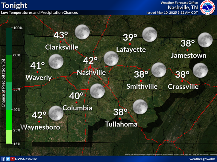
Back to the 50°s!

Current Radar 

TONIGHT – 52° by 7 PM

This evening will be pleasant, with dinnertime temperatures in the low 50°s, and skies will be mostly clear.

A southerly wind will really settle-in overnight. Skies will stay mostly clear through the morning hours & lows will fall to the mid 40°s. read more

A Grammy-Worthy Week’s End

Current Radar 

(Editor’s Note: Intern Applicant Week continues…) 

I am Brendan Schaper, a professional broadcast meteorology student at Mississippi State University, here to be the bearer of good weather news! Nashville stays quite chilly today, but temperatures will be climbing back to near-normal Thursday and above average temperatures are expected for the weekend. read more

Rain Ends Tonight. Slow Improvement On The Way.

Current Radar 

Rain Ending Tonight

The rain should pull away by 9 PM. Here’s the HRRR’s prediction:

Notice the snow at the TN/KY line. As the precip moves out, there is a possibility we’ll briefly see a little sleet/snow mix north of I-40 tonight — we are already below freezing at 5,000 feet. No local accumulation or travel problems expected. read more

ALMOST Done With the Rain

Current Radar

Well unfortunately we are not escaping the rain quite yet.

kim_kardashian_cry

Today into Tonight HIGH 43 LOW 33:

Rain showers will resume around the early lunch hours and on into the rest of the day. These showers will stay around pretty much the entire afternoon. The showers remain constant throughout the day and will continue into the evening hours. No major flooding is a concern today; however some localized flooding on smaller roads is still possible with how much rainfall has been seen in the past 24 hours. The temperature will stay around the low-40°s throughout the day. The temperature will drop into the evening hours, but is not expected to get below freezing. Since most of the moisture will be out of our area by the time the temperature drops, there should be little to no snow accumulation into tonight. read more

Rainy Monday and a Preview of Spring!

Current Radar 

Now that our little bit of winter precip is over, it is all rain for here on out!

snoopy rain

For the rest of your Monday: We have rain, and lots of it. Some of the rain will be heavy, but the good news is it will start to wind down by this evening. We don’t expect flooding to become a big issue, but some localized problems are possible. The highs today will only be in the low-mid 40°s with a wind chill getting down into the 30°s. read more

Maybe a Few Icy Hours Along & N of 40 Tonight; Rainy 24 Hours

Current Radar 

Rainy Night

After a few early afternoon hours of sleet and snow, the rain left.

Now the ice is trying to come back for a few hours tonight.

Just issued by NWS, statement — "wintry mix will continue this evening north of I-40." pic.twitter.com/HA73WEgJiX read more

What’ll We See?

Current Radar 

Radar indicates snow already to our NW.

This should work down I-24 this morning, and mainly impact areas along and north of I-40. There is not much of it, but as I write this, temps at the surface and aloft are all below freezing, so it should be snow. Yet the air aloft is also pretty dry, meaning much of this snow will evaporate before we will even see it. So, we think this will be a little “pre-event” light snow, but not a big deal. read more

Sunday Winter Weather: Snow/Mix >>> Rain

Current Radar 

Updates from this morning in red.

Wintry Mix Sunday Afternoon >>> Rain Sunday Night

Precip will move in Sunday afternoon. We are calling it “precip” because it may take many forms during the day and night, depending on the time, your exact location, and maybe even your elevation. This is life in Middle Tennessee, right on the line of stuff. read more

Cold Weekend Ahead, Update on Sunday/Monday Snow Potential

Current Radar 

Few Flurries Tonight?

Notice that the HRRR model has a few flurries possible late this evening as the surface low moves east.

Right now there is no reason to be worried about these.

Saturday – Sunshine But Much Colder! Waking Up: 17° High: 28°

High pressure will be in full control of our weather for Saturday, driving in frigid temps on a north wind. read more

Clipper Tonight?, Cold Weekend, Sun/Mon Snow?

Current Radar 

TONIGHT – Snow?! – Wake Up Tomorrow: 26°

We’ll get to the mid/upper 20°s overnight tonight and into Friday morning, but there should not be anything left to freeze.

Another Clipper Tonight/Friday?

The snow that was in the Dakotas earlier today has made it down to parts of Iowa and even Missouri this evening: read more