Higher Rain Chances Through Thursday, Clearing Out This Weekend

Monday

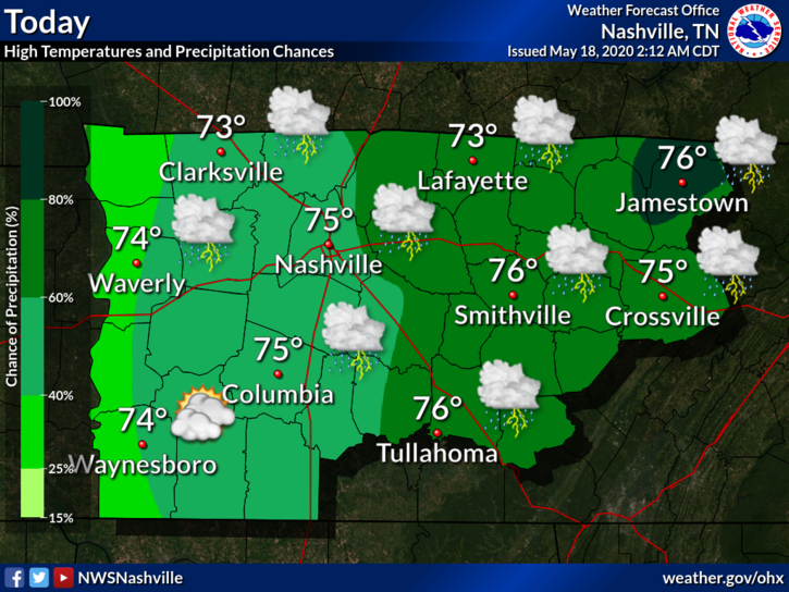
Scattered showers and thunderstorms will be in the forecast for today. Some of the storms could have gusty winds and heavy downpours, but no severe weather is expected. Up to half of an inch of rain is possible. Highs will be near 75°.

There’s a slight possibility of some showers tonight, but should stay mostly cloudy. Lows will be around 57°.

Rain Chances Climb Through Thursday

This is thanks to two different low pressure systems: one going across the Gulf Coast and the other coming from the northwest.

The system to the south will clear out today, but the northern system will move in Tuesday. It will continue to spark some showers and thunderstorms, primarily in the afternoon. Highs will be in the upper 60s and lower 70s.

This trend will continue into Wednesday and Thursday, when the system will begin to move out. Highs should be in the mid to upper 70s for both days.

Severe weather is currently not in the forecast for this week.

Heavier rain will be in East Tennessee. We should be looking at around three-quarters of an inch of rain through Thursday, but higher values cannot be ruled out because of downpours with some thunderstorms.

What About Memorial Day Weekend?

The low pressure system will be moving out Thursday, which will give way to warmer temps and clearer conditions this weekend.

There is still a slight chance of a shower or thunderstorm passing through. Grab that umbrella just in case, but weather should stay relatively nice. Temps will rise, going into the upper 80s for Saturday and Sunday.

Scattered Storms Possible This Weekend, Cooling Trend Next Week

Friday

There is a possibility of some showers and thunderstorms throughout the day today. There will also be a southwest wind blowing at 15 mph with some gusts reaching 25 mph. High temp will be 84°.

Tonight the winds will die down and there will be mostly cloudy skies. Lows will be around 65°.

Going into the weekend

The trend of scattered showers and thunderstorms will carry into the weekend.

Highs will be in the mid to upper 80s on Saturday. Most of the rain (if any) should be arriving between 2 pm and 7 pm.

A cold front will pass through Sunday, which will bring the possibility of some storms primarily after 1 pm. Severe weather is currently not forecast, but there could be some rumbles of thunder with storms that do develop. Rainfall should stay below a quarter of an inch. Highs will be in the upper 80s.

Much like the past week, it shouldn’t be a washout. However, keep that umbrella handy if a shower or thunderstorm was to form.

Cooling down next week

Rain will stick around into Monday morning while the cold front is moving out.

Thanks to that cold front, temps will return to the lower to mid 70s for the beginning of next week. It will also be sunny throughout the week with rain chances staying relatively low, which makes for some great weather!

Cooler and Sunny Monday, Rain Chances Increasing Throughout Week

Monday

Although cool, it’s looking to be a nice day today. The high temp will reach around 63° with sunny skies.

Clouds will return overnight, with temps dropping to 44°.

Rain Returns Tuesday and Wednesday

Rain chances increase after 9 am Tuesday. Highs will be in the lower 60s.

These rain chances continue overnight all the way into Wednesday, where high temperatures will increase into the lower 70s.

It won’t be a washout, just some spotty showers. The Weather Prediction Center is only estimating up to a tenth of an inch of rain through Wednesday.

Warmer Temperatures Ahead

There is definitely going to be a warming trend happening later this week.

Thursday will bring a break from rain. Highs are expected to reach the lower 80s.

This weekend brings chances of showers and thunderstorms to the table. Severe weather is not currently forecast. Highs will be in the mid 80s.

It would probably be a good idea to keep that umbrella or rain jacket handy this week in case a shower or thunderstorm does pop up.

Rain Clearing Out Today, Returns Friday

After the past two rounds of severe storms that have come through the area, we’re finally getting a breather.

There will be a cold front passing through today during the morning and afternoon hours, which will bring us some spotty showers. Rain chances will diminish overnight.

Looking Ahead

Temps will begin to drop tomorrow, where the high is forecast to be around 61° for the Nashville area, a 15 degree drop from the high for today! Spotty showers will be possible, but it should be relatively dry with some cloudy skies.

HRRR model showing rain through early afternoon Wednesday.

Thursday is looking to be a really nice day. The sun will make its grand appearance and temps will be in the upper 60s and low 70s. Rain will return late that night, going into early Friday morning.

Friday brings a much higher chance of rain across the area. Showers and thunderstorms are possible throughout the day. Rain chances will begin to increase after 8 am and last into the nighttime hours. This looks to be a general rain/thunderstorm event. No severe weather is expected with this system. However, another cold front is coming in, which will cause temps to drop even lower.

There is a chance of some frost into Saturday morning. Some covering may be needed for those flowers and plants that may have just been put in the ground. Clear skies are expected during the day and overnight.

NWS Nashville Forecast High/Low Temperatures

The sunshine will stay for a few days to start next week!

Snow, Sunshine, and Rain All in Forecast for Next Few Days

This is not a drill: it snowed! Everyone has been buzzing about the event, and the trend of snow flurries to light snow showers will continue across the area for much of the day. According to the NWS Nashville Twitter page, their office has received 0.9″ of snow! However, further accumulations cannot be ruled out.

Any additional accumulations are likely to remain under an inch, mainly east of I-65. Radar shows isolated bands of heavier snow showers, which is where any further accumulation would take place. – NWS Nashville, February 7, 2020

Highs will be around 37, but there could be a windchill below freezing because of the high winds (5 to 15 mph with gusts upwards of 20 mph). Definitely go out and enjoy the winter weather while it’s here!

Model showing wind chill values

The snow will move out tonight. There will be mostly cloudy skies with a low near 30.

It will be a cloudy start to the day on Saturday, but sunshine will return by afternoon. The high will be around 46. Clear conditions will last into the night with lows near 30.

The sun extends its stay into Sunday, with temperatures climbing to the upper 50s. The winds will begin to pick back up during the day, blowing 5 to 15 mph with wind gusts upwards of 20 mph.

Rain will return Sunday night after midnight. Lows will be around 49.

Rain continues into Monday and Monday night. Highs will be around 56, while lows will hang around 42. This trend will continue through at least Thursday, with models showing over 2″ of rain in areas by the end of next week. Make sure to grab that umbrella on your way out the door this week!

We are already under flood advisories, so additional rain could cause more flooding issues. If you see a roadway that is flooded, always remember: TURN AROUND, DON’T DROWN!

Cool and Rainy Friday, Sun Returns Sunday

Clouds will linger for the day today, keeping the high at around 49. Light rain creeps closer late tonight and early Friday morning. Low temperatures will be close to 38.

High temperatures will stay around 49. It’s not going to be a washout; models expect a tenth of and inch precipitation falling off and on during the day. Wouldn’t hurt having that rain jacket or umbrella ready! Rain tapers off Friday overnight.

By mid-Saturday morning rain should be out of the area. Conditions will still be cloudy with a high around 52. There will also be a west wind at 5 to 10 MPH present throughout the day. Overnight, clouds will begin to move out, going to partly cloudy conditions. The low temperature will be around 37 with the wind sticking around.

Here Comes The Sun!

Sunday is looking to be a great day! There will be plenty of sunshine with highs close to the 60’s. The clear conditions will continue through the night with lows close to 44. However, it’s looking as if there’s another system coming to the area at the beginning of the next work week. So make sure you go out and enjoy the beautiful weather!