When It May, or May Not, Rain or Storm Today through the Weekend.

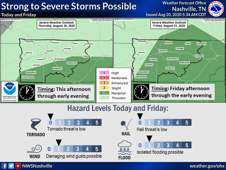
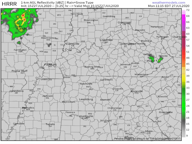
Scattered Shower and Storm Set Up Thursday

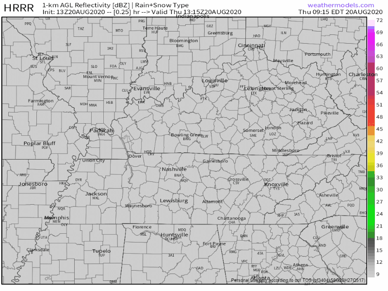
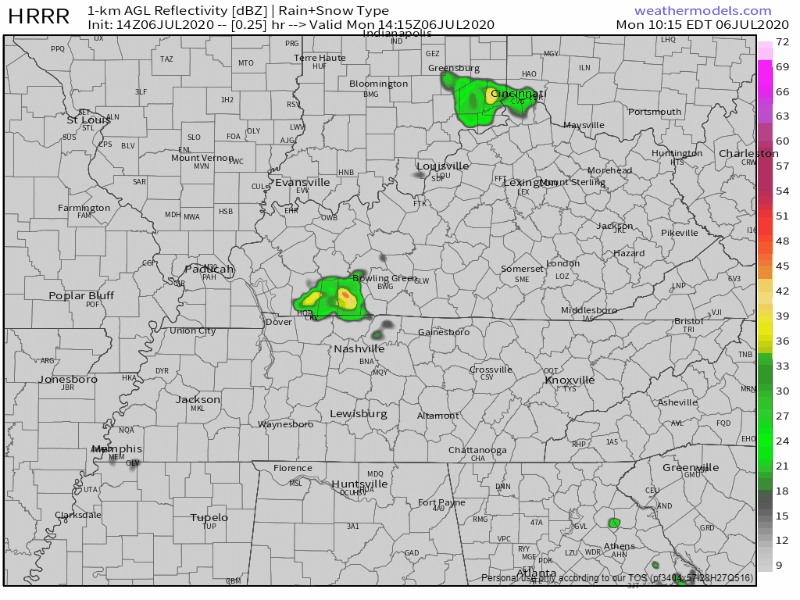
The HRRR model shows showers and storms beginning to pop up around 3 pm. Some people may get some rain while others don’t see a drop.

Stronger storms should remain to our south, but we can’t rule out one rolling into your neighborhood. The main threats with strong storms are gusty winds, lightning, and heavy rainfall. But that’s pretty unlikely.

If you have outdoor plans, keep an eye out on your radar!

Temps will reach around 88°, which is normal for this time of year. Dew points will be hanging out in the mid to upper 60s, reaching as high as 68° this afternoon. Kinda sweaty.

Rain & Storms More Likely Friday

Rain and storms look like they will be more organized and more numerous Friday than what we’ve been seeing. The HRRR model has them beginning to enter our area around 3 pm.

Main threats will be some gusty winds, lightning, and briefly heavy rainfall.

The Storm Prediction Center has put us under a 5% chance of seeing strong winds (around 60+ mph) within 25 miles of us.

According to the Weather Prediction Center, we could get up to half an inch of rain just on Friday. Locally higher amounts are possible from downpours within storms.

Storms May Continue Saturday, Clearing Out Sunday

Rain will be possible anytime Saturday, although it will be most likely in the afternoon. NWS-Nashville estimates 0.21″ total from 7 AM Saturday to 7 PM Saturday. Most of that in the afternoon.

The Euro model shows scattered rain Saturday. NWS-Nashville’s 0.21″ forecast may be an average rainfall across the area, such that one area of town gets 0.42″, while others get nothing. Rainout or dryout possible.

Storms may accompany this rain, so be sure to have enclosed shelter access if hiking, golfing, boating, or whatever.

Sunday is looking to be a bit drier!

For this time of year, can’t safely say we won’t see any rain, but we should be looking at some sunny skies for much of the day! A mid/late afternoon sneak rain/storm attack is possible.

Good Things Can’t Last Forever…

Higher dew points return next week.

After Sunday dew points will be rising into the upper 60s and lower 70s. High temps will also be reaching into the lower 90s, making it feel very hot and sticky outside.

Let’s Get Through The Humidity This Weekend, Then We Can Take A Break On Monday

Drier Saturday, but Looking at High Dew Points (Still)

The HRRR is showing much of the rain staying in the far east portion of the state today.

We can’t rule out a stray shower or storm rolling into your backyard late this afternoon, but we should be looking at some drier conditions.

Highs will be around 90° with dew points in the lower 70s for the day. Heat index values are only looking to reach the lower to mid 90s this afternoon.

Slight Chance of Rain Remains Through Sunday

Key word: slight.

A front will will be coming through the area tomorrow afternoon, which will bring some showers and storms. The HRRR shows them beginning to pop up around 3 pm.

There’s currently no severe weather in the forecast.

Some people may get wet while others don’t see a drop of rain. If you have afternoon plans, keep that radar handy in case something is to develop.

It doesn’t look to be a washout. The Weather Prediction Center is predicting around a tenth of an inch of rain to fall, but there could be locally higher amounts with some storms.

Before that cold front hits, it’s still going to be hot and muggy. Highs will be in the upper 80s and dew points in the lower 70s.

However, after it passes, dew points will begin to drop into the lower to even possibly mid 60s overnight.

We’re Finally Getting a Well-Deserved Break from the Humidity Starting Monday

High temps and dew points will both begin to drop next week. Here’s what the National Weather Service had to say this morning:

For the ext temps, with the troughing pattern anchoring in, looks like temperatures will run a couple degrees below normal. At any rate, expect a little break from the oppressive humidity that comes with those 70+ dewpoints.

NWS Area Forecast Discussion

Highs will stay in the upper 80s, but dew points are dropping into the mid to upper 60s. It will still feel a little sticky outside, but definitely a lot better than it has been!

Hot Today, Scattered Storms Continue Through the Forecast

Tuesday

It’s going to be hot.

High temps will be around 94°, but the dew point will reach as high as 73°. This will push heat index values into the upper 90s and even low 100s.

We should be relatively dry throughout the day. The HRRR has most of the storms staying west and south of us.

Can’t rule out a stray storm popping up in your neighborhood, so take a quick peek at the radar if you have plans this afternoon and evening.

Wednesday

A trough to our west will increase the chance of some scattered showers and thunderstorms. They’re expected to start popping up around 3 pm. There’s currently no severe weather in the forecast, but there could be some gusty winds, lightning, and heavy rain with some of the stronger storms.

It won’t be a washout, only a tenth of an inch to a quarter of an inch of rain is expected right now. Locally higher amounts can come from heavier storms.

Highs look to be in the upper 80s with dew points in the lower 70s. Heat index values are expected to be in the lower to mid 90s.

Looking Ahead

The rest of the week is looking a lot like Wednesday: high dew points and scattered storms.

Highs will remain in the upper 80s and low 90s through the weekend. Dew points will remain in the low 70s.

According to the National Weather Service, we may be looking at a front coming through to start next week:

Somewhat of a cool down may commence by Tuesday with max temps in the grids showing mid 80s, with mid 60s dewpoints. I’ll take it!

NWS Area Forecast Discussion

Something to keep our eye on, but we will take those lower dew point values!

3 Years Old

That was the age of the latest victim left in a hot car.

They gained access on their own, which makes up 26.3% of the reported deaths from a child being left in a hot car.

This one also hits a little closer to home: it happened in Alabama. Very close to Tennessee. A death still hasn’t been reported in our state, but that doesn’t mean we’re out of the woods yet.

It can happen to anyone, but you can help prevent it by double checking your backseat before getting out of the car.

Comfortable Temps to Start the Work Week, Warming Up Toward the Weekend

Monday

That cold front that came through this weekend is doing us some good.

Even better news? There’s another one that’s coming through tonight into early Tuesday morning.

Dew points are expected to reach 65° this afternoon. It will still feel sticky outside, but mixed with those lower temps, it’s going to feel noticeably better than what we experienced in late July.

A big portion of the rain should stay in far eastern Tennessee, but we can’t rule out some pop up showers and thunderstorms rolling into our neck of the woods. They should begin to pop up around 3 pm and be out of the area before midnight.

There is currently no severe weather in the forecast, but here’s what the National Weather Service had to say about any storms that do pop up:

Could hear a few claps of thunder here and there, but not expecting anything more than a couple weak thunderstorms if that.

-NWS Area Forecast Discussion

Tuesday

Tomorrow is going to feel great!

With that cold front moving through overnight, highs are looking to be in the low to mid 80s (crazy right??). Dew points will remain in the mid to upper 60s.

It should stay dry throughout the day, but we can’t rule out a stray shower or storm popping up in your neighborhood.

Our greatest chance of seeing any rain would be after 1 pm.

If you have any afternoon or dinner plans, just watch that radar for any pop up showers and storms.

Warming Back Up

…sadly.

We knew this wouldn’t last forever, but we definitely wish it would last more than a couple of days!

Wednesday will be much like Tuesday with highs in the low to mid 80s.

Thursday and Friday will begin to warm back up into the upper 80s and low 90s, much like we’ve been seeing.

The big kicker: dew points will be staying in the mid 60s. We’ll be getting a break from those awful heat index values.

We’ll still be following the same “scattered showers and storms” set up.

14

That’s the number of kids who have died in hot cars this year. The latest child was 8 months old.

The numbers are continually going up. We haven’t seen a case in Tennessee yet, but that doesn’t mean it won’t happen. Make sure to check your backseat before you get out of the car. Put something of importance back there: a purse, laptop, phone, even one of your shoes. This will cause you to do a double-take of your backseat.

Don’t just crack the windows! It still gets super hot super fast in a car, even if the windows are cracked.

Rain Continuing Today, Cool Down to Start August

Saturday

Some areas have already gotten wet today and scattered showers and storms will continue throughout the afternoon and evening hours as a cold front moves through the area. They should be heading out before midnight.

There’s no guarantee on where rain will fall, so some people will get wet while others stay dry.

There’s currently no severe weather in the forecast so the main threat with any storms that pop up could be some locally heavy rain.

With the mix of rain and the cold front, temps should continue to stay in the lower 80s and even possibly upper 70s. Dew points will begin to fall into the mid to upper 60s, making the evening hours feel pleasant outside.

If you have any evening plans, keep an eye on that radar for those pop up showers and storms!

Cooler Temps Ahead

That’s what we’ll be looking at after Sunday!

Monday will be our next chance at some rain, but it’s not looking like a washout. According to the Weather Prediction Center, anywhere from a tenth of an inch to a quarter of an inch is possible. There could be some locally higher rain totals.

The rest of the work week looks great!

Dew points are looking to stay in the mid to upper 60s. It will still feel sticky outside, but a lot better than it has been.

Highs should stay around the mid 80s, but will gradually climb as the week goes on.

Scattered Storms Monday, Becoming More Organized Throughout the Week

Monday

We’re still following that typical summertime pattern: hot and humid with some afternoon storms.

The dew point will reach around 73° today. This will help those heat index values to get up into the upper 90s and possibly even 100 in some areas.

That dew point will also continue to help spark those scattered afternoon storms.

Developing storms should be leaving the area around midnight.

Even with the models, it’s still hard to pinpoint what locations will be impacted (if any). You may see some rain while your friend 15 minutes away doesn’t.

Severe weather is currently not forecast with these storms. If you are impacted, you could see some heavy rain, cloud-to-ground lightning, and some gusty winds. If you have outdoor plans this afternoon, keep an eye out on the radar!

Tuesday

A cold front will approach from the north, but likely not push all the way through the area on Tuesday. But, temps should back off a smidge due to increased cloud cover and rain.

Rain chances will begin to increase throughout the day. Models are showing that we will be looking at some more scattered showers and storms. Some people may get wet while others stay dry.

Severe storms are still not in forecast, but we could continue to see some heavy rain, CG (cloud-to-ground lightning, and gusty winds with some of the heavier storms.

Rain totals right now are anywhere from a tenth of an inch to a quarter of an inch for Tuesday. Areas impacted by heavier storms could have locally higher amounts.

Looking Ahead

Showers and thunderstorms will become more organized throughout the week. Severe storms are not in forecast, but heavy rain is currently the big focus.

Through Saturday, the Weather Prediction Center is predicting anywhere from 3 to 4 inches of rain across Middle Tennessee. There could be some locally higher amounts for areas impacted by downpours from heavier storms.

Avoid flooded roadways: turn around, don’t drown!

Because of the added cloud cover, we’ll be looking at some relief from those temps. Highs are looking to be in the mid to upper 80s.

The Heat is Here to Stay, Storm Chances Slightly Lower for the Weekend

Friday

At 10 am, the heat index has already been recorded at 90° and the dew point at 72°.

Heat index values will be in the upper 90s today, but some places could see some feel-like temps of 100.

The dew point will stay in the lower 70s today, which could help to spark some showers and storms.

The HRRR shows storms beginning to develop around 2 pm, but should be out of the area before midnight. These will be much like the storms we’ve been seeing: lots of cloud to ground lightning, heavy rain, and some gusty winds.

Some people will get wet while others don’t see a drop. If you have plans this afternoon, make sure to keep an eye on the radar!

This Weekend

It will follow the same setup we’ve been seeing, just with some slightly lower storm chances.

Saturday we’re looking at heat index values in the mid to upper 90s, reaching around 97°.

Sunday will be much of the same, reaching as high as 99°.

Dew point values will remain in the lower 70s, making it feel super sticky outside.

Although the storm chances are lower, they aren’t zero. The main time frame they will begin to form (if they do) will be anywhere from 2 pm to 8 pm. Although there’s currently no severe weather in the forecast, some of the more intense storms will continue to have cloud to ground lightning, heavy rain, and gusty winds.

These summertime storms are hard to pinpoint, even with these models. Keep up with the future forecasts if you have afternoon plans this weekend!

Looking Ahead

The heat is here to stay.

A system may be coming through the area on Tuesday, increasing our rain chances. It’s still far out, so models are having a hard time agreeing on timing and intensity.

Heat Safety

The total amount of car deaths for the nation has risen to 11.

Make sure to do a double check of your backseat before getting out of the car. Don’t just leave your windows cracked – temps in the car will still rise very quickly.

Getting a Break from the Rain, But Dangerously Hot Temps on the Way

Monday

The sun has returned to start the work week.

There may be a stray shower that could pop up in your backyard, but for the most part we will be dry. The HRRR model shows most shower formation being south and west of us.

Dew points will be in the mid to upper 60s, getting as high as 69° this afternoon. This will make it feel sticky outside, but the heat index will stay around 91°, which is lower than it has been.

Dangerous Heat

That’s what we’ll be facing later on this week.

Tuesday looks to be a lot like today with heat index values reaching 94°. Wednesday, on the other hand, will be the recommended day to stay indoors.

Temps will be climbing into the upper 90s, possibly even low 100s for some areas. This will cause the heat index values to be 100+.

On That Note…

With the dangerously high temps coming, make sure to do a double check of your backseat.

Here are a couple facts on hot temps and a car:

When temperatures outside range from 80° to 100°, the temperature inside a car parked in direct sunlight can quickly climb to between 130 and 172.

Centers for Disease Control and Prevention

In terms of heat-rise over time, it makes very little difference whether a car’s windows are closed or partially open. In both cases, a car’s interior temperature can rise approximately 40 degrees within one hour, even when the exterior temperature is only 72°.

American Academy of Pediatrics study (2005)

Vehicular heat stroke is the second leading cause of death for children under the age of 14, just behind car crashes.

Not only do we want to protect those kids, but we want to remember our furry friends, too. In 2019, it was reported that 53 animals died in hot cars and 126 were rescued.

Looking Ahead

Rain chances begin to climb again on Thursday and through the weekend. They look to be scattered showers and storms, so keep an eye out on the future forecast if you have any outdoor plans.

Dew points will begin to climb in the lower 70s again, making those heat index values remain over 100 in some areas. Make sure to practice heat safety!

Heat, Humidity, & Storms Thru the Weekend.

8 Vehicular Heatstroke Deaths So Far in 2020

The youngest victim was 10 months old.

There have been over 800 deaths from vehicular heatstroke since 1998, and over half of those (54%) have been from kids under the age of 2.

It gets really hot really fast in your car, even if you leave the windows cracked. Before you get out, make sure to double check your backseat!

Editor’s Note: Most of these tragedies are accidents that happen to otherwise good parents. Don’t let it happen to you.

Thursday

Oppressive humidity remains. Dewpoints near 73° signals a lot of moisture sitting on us. Add temps up to 94° and the heat index will hit the upper 90°s.

Heat will cause that wet air to rise, then gravity will take cover. Storms will scatter across the area, one may scatter on your head. Models think this rain chance will begin around 2 pm then out of the area a few hours after dark. Storms may arrive earlier. Yesterday models thought they’d begin around 2 pm but they started forming around noon.

Lightning is the main concern with storms today. A few may contain strong winds, like this downburst we saw yesterday near Lennox Village.

Some of us may get wet while others see nothing. Keep an eye on the radar if you have any outdoor plans this afternoon!

Storms Coming from the Northwest

Friday. A system out of the plains will go just south of us Friday. As that happens, it should more scattered storms than we’ve been seeing this week. Additional storm ingredients will be in place, so these may be a bit stronger than what we’ve seen this week.

The typical heavy rain and frequent lightning will still be there, but some stronger winds are possible. Why? More shear:

Shear will increase in response which could allow a couple storms to become strong to severe with damaging winds.

NWS-Nashville AM Forecast Discussion 7/9/20

Saturday seems to be a “drying out day,” although we cannot totally rule out a storm. Dew points will slightly dip into the mid to upper 60s. It will still be sticky outside, just not as bad as it has been. The heat index will drop into the low to mid 90s.

Sunday brings us another system out of the Dakotas. Models have not been as consistent on if this will hit us dead on or if it will drift just southwest of us.

This will be something to focus in on the next couple days. We could be looking at some more strong to severe storms, but it is still too early to pinpoint what locations will be impacted.

Once again with the increased shear and an amply unstable atmosphere, a couple storms could be strong to severe.

NWS-Nashville, Morning Forecast Discussion, 7/9/20

Make sure to watch for those future forecasts!

Typical Summertime Pattern This Week: Hot and Humid with Afternoon Showers and Storms

Monday

Looking to be another hot and muggy day. Dew points will reach as high as 72°, which will help the heat index climb up to 96°.

Those high dew point values don’t only help the heat index: they also help to fuel those scattered showers and storms we’ve been seeing.

According to the HRRR, storms should begin to fire at around 3 pm, but become more widespread around 5 pm. They should be leaving the area after midnight. One could roll into your backyard, but not your friend’s house down the road.

No severe weather is currently in the forecast, but these storms could pack a punch. Lightning, gusty winds, and some localized flooding are all possible. If you have afternoon plans, make sure to keep an eye on that radar!

Looking Ahead

The rest of the work week is looking to follow the same trend as today: high heat index values, high humidity, and afternoon rain.

The heat index looks to be in the mid to upper 90s (and posisbly reach low 100s) for Tuesday and Wednesday.

Dew point values will stay mainly near the 72° to 73° range throughout the week. There will be a small break on Sunday, where they will drop down into the upper 60s.

With those dew points staying high, the chance of those showers and storms will linger. Although they are not in the forecast to be severe, they will still have the chance of some lightning, gusty winds, and heavy rain.

These storms are hard to pinpoint, especially this far out. Some of us will get wet, while other don’t see a drop of rain.

Did You Know?

2018 was the deadliest year on record of children dying in hot cars with 53 kids.

According to National Safety Council, over 800 kids have died since 1998 because of a vehicular heatstroke.

A quick way to make sure you take one more look in the back seat is to place something of importance back there, such as a purse or even one of your shoes. Even if you’re just running a quick errand and leave the windows cracked, it gets really hot really quick in a car.

Quick Look at the Tropics

We had our 5th (!!) storm named Sunday night: Edouard.

This is the earliest an E name has been given, breaking the previous record by Emily in 2005.

There are also two other disturbances to keep an eye on in the Atlantic.