“Northwest Flow” is weather nerd for winds blowing from the north west. Our rain/mix/snow will be riding NW flow overnight through Saturday night.
Saturday will be cold. We won’t get higher than the low 40°s.

“Northwest Flow” is weather nerd for winds blowing from the north west. Our rain/mix/snow will be riding NW flow overnight through Saturday night.
Saturday will be cold. We won’t get higher than the low 40°s.

Remember, a “Watch” covers a large area and means “be ready.”
A “Warning” (which we will post to Twitter @NashSevereWx — which you can find by clicking the top banner — but not to the blog itself) means take cover: the warned severe weather event is imminent or occurring in a small, specific area.

Storms will form a long line on radar, called a squall line, which will quickly speed through Wednesday morning. They should be packing quite the punch:
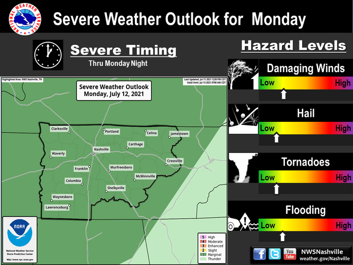
The probability of any of these happening withing 25 miles of you is 30%.

A significant severe weather event is setting up today and tonight along and north of the Ohio River.

This is the system that will set off storms with severe weather potential for us Wednesday morning.

Light rain will arrive while we sleep, and continue through the morning commute. The HRRR model thinks this rain will last through mid-morning:

Other models, particularly the NAM3 model, think the rain could linger off and on into Monday afternoon.
But first, let’s talk today thru Tuesday.

Sun this morning will turn into clouds later today and tonight. The HRRR model shows light rain approaching by midnight.

Expect light rain while we sleep tonight.
All these temps will be close to record highs, running 15° to 20° above the average temp for late February.
Let’s unpack those rain chances from the crap-app posted above.
Models remain inconsistent in predicting this event. One model (the GFS) thinks most of the rain will go south of us. The other model (the Euro) also has most of the rain south of us, but thinks we will get some rain during the day. The NAM3 model is getting into range (it’s posted below, looking at the wee hours of Tuesday morning through lunch), and it too has very little/no rain for us. It’ll be a cloudy day for sure, but for now (check back on this) my gut says only a small amount of rain Tuesday.

North winds and clearing skies = big time cool down.
A boring weather pattern will be (yawn) interrupted by some rain late Tuesday night.

No severe weather or other shenanigans expected.
No rain is expected; but remember, next weekend is too far away to make any promises.
A Cold Front Arrives Today
Upper 60°s, clouds, humidity, and a small chance of a light sprinkle will linger this morning. All this will end this afternoon thanks to a cold front. You’ll know when the cold front is here when rain picks up and/or the wind starts blowing steady and chilly from the north. After that happens, the rain chance is over. We don’t expect rain after lunch.
Severe Weather Possible Tuesday
You must be logged in to post a comment.