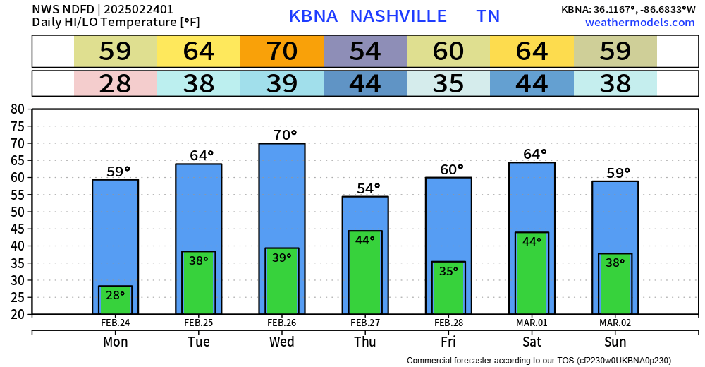
70° by Wednesday. Late Weds / early Thurs a cold front sweeps out the warm temps, only for us to warm up again.
A little rain Thursday morning with the front passage, not much, no big deal.
Weekend looks weather boring.

70° by Wednesday. Late Weds / early Thurs a cold front sweeps out the warm temps, only for us to warm up again.
A little rain Thursday morning with the front passage, not much, no big deal.
Weekend looks weather boring.
Upper 20°s tonight in Columbus. No precip. Winds unlikely to be an issue. Dewpoints falling through the teens, you’ll want chapstick.
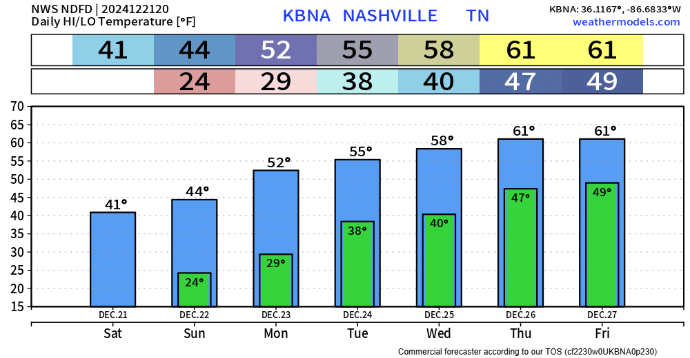
Back home: warmer each day this week.
Rain possible Christmas Day thru at least Saturday.
FRIDAY LATE AFTERNOON – EARLY EVENING
Sprinkley rain may pull up. Meh.

SATURDAY AFTERNOON TO SUNDAY AFTERNOON
The problem: I’m not sure when it will stop. Most of the rain should be gone by Sunday mid-morning, but for the rest of Sunday we could get a stray shower. Poncho up, fans. Tailgates need tents!

COLD MORNINGS
Warming trend: check out the highs.
RAIN THIS WEEKEND
… a trailing cold front will approach Middle Tennessee on Saturday afternoon with likely rain chances late Saturday through Sunday morning.

Behold below! Another sourced forecast from available model data + NWS-Nashville guidance. Delivered with fear and trembling.
EARLY WEDNESDAY MORNING (AS IN, TOMORROW)
Snow, brief and inconsequential.

Rain – maybe heavy at times – expected before dawn Tuesday morning.

Disclaimer

Very light showers Tuesday night may become a narrow band of snow early Weds morning.

Temps plummet Weds and Thurs …

“We expect some light accumulations tomorrow afternoon mainly north of I-40 and east of I-24 as an upper trough swings across Middle Tennessee. Despite high pressure building in at the surface, there does appear to be enough moisture and lift aloft to product some light snow with accumulations up to 1/2″ possible.”

–It’s going to rain this weekend. Off and on. Some downpours. Some dry spells.
–When exactly?
–Knowledge of exact timing would be great, but rain follows no schedule. /smug phrasemaking satisfaction smirk/.

Radar estimated rainfall had about 0.75″ on average across Will Co from this morning’s lightningstorm. Needed it, but the timing stunk. Others got 0.25″ or so across Nashville.
Expect temps Sunday morning 13° colder than this morning. (This does not say it will be minus 13 tomorrow morning, it’s a 24 hour temp change graf).
It’s raining this afternoon for the lucky ones. Lightning likely. Low lapse rates and other factors expected to keep storms below severe thresholds. We’re covering this on X/IG.
Line should clear around 5 PM north of Nashville and by 7 PM south of 840.
You must be logged in to post a comment.