Not Much Rain In Sight, But Heat Sure Is

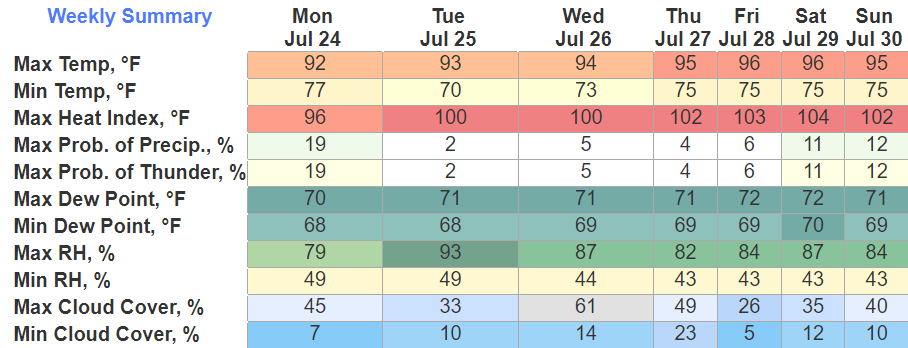
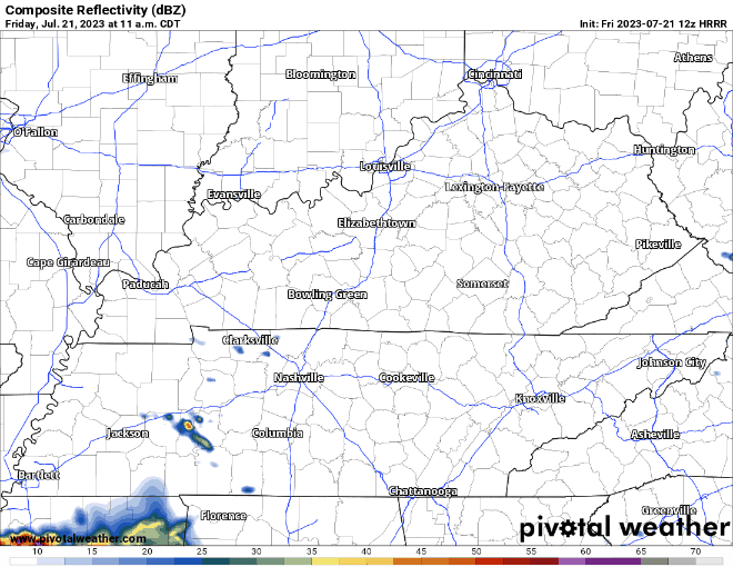
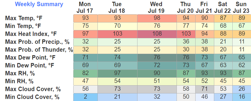
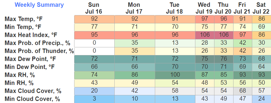
Not much in the way of rain for the next 7 days. Each day carries a very small chance of some, you’d be very lucky (or unlucky) if you got some.

Temps slowly increase into the mid 90’s by midweek and heat index values will be from 100° – 105°. This is justtt below Heat Advisory criteria, but doesn’t mean it should be taken any less seriously. Take frequent breaks and drink plenty of water. read more

Humidity Only Gets Worse

Today will be the best day out of the next seven. Lowest humidity, dry, lots of sun. Great day for some soccer (or fútbol).

Hany Mukhtar Soccer GIF by Nashville SC

After today, we stay dry (probably, very unlikely but a stray shower or storm can’t totally be ruled out), but humidity increases and temps will feel like mid to upper 90’s the rest of the week. Typical for late July. read more

Dry, Dry, and More Dry

We (finally) get a few days of dry and not-so-bad humidity. Can’t complain for late July. Heat and humidity picks up a bit Tuesday and hangs around the rest of the week, but rain chances stay low. read more

Finally, Some Relief

For the first time since Monday, I don’t have to mention severe weather or flash flooding in the title. Whew.

HRRR model (above) keeps most of the activity to our south today. We may see a stray shower, but mostly dry. Finally. read more

More Chances at Severe Weather + Flash Flooding Today

We yet again have chances for severe weather and flash flooding today.

The Storm Prediction Center has outlooked us with a:

  • 15% chance of damaging straight-line winds within 25 miles
  • 5% chance of severe hail within 25 miles
  • 2% chance of a tornado within 25 miles

Additionally, the Flood Watch that was originally set to expire at noon has been extended until 6pm. “Flash flooding caused by excessive rainfall continues to be possible…” Head on a swivel, especially if you live in a flood-prone area. Turn around, don’t drown. read more

Continued Chances For Flash Flooding and Severe Weather Thru This Afternoon

9PM UPDATE

Things have changed a little since this morning. Both counties will be under a Flood Watch from midnight tonight until noon Thursday. 1-3″ of additional rain is possible, with a few pockets containing heavier rain possible. Rain may begin as early as the wee-hours of Thursday morning and continue until Thursday afternoon. read more

Flooding Concern Overnight Into Wednesday, Low Probability of a High Impact Event

Both of our counties are under a Flood Watch until noon Wednesday.

“Many areas will exceed 2 inches of rainfall. The exact location are uncertain, but some sports could have torrential rainfall exceeding 5 inches causing significant flash flooding.” read more

Multiple Rounds of Severe Weather Possible Today and Tonight, Flash Flooding Concerns

The Storm Prediction Center has outlooked us with the following probabilities, all within 25 miles.

  • 30% chance of damaging (58mph+) straight-line winds
  • 15% chance of severe (1″+) hail
  • 2% chance of a tornado

Additionally, the Weather Prediction Center has outlooked the majority of our counties with “at least 40%” of flash flooding occurring within 25 miles, with the rest of us with “at least 15%” also within 25 miles. read more

Smoke. Severe Weather. Heat. Welcome To Middle TN!

Smoke

Smoke from wildfires in Canada has made its way down here and caused some hazy conditions.

This looks more like a scene from an apocalypse movie, but nope, it’s Nashville.

This haze and smoke will linger, leaving us with an Air Quality Alert today. Take it easy if you have respiratory issues. Smoke will clear by Tuesday. read more

The Dawg Days of Summer

Today will be the only guaranteed dry day of the week, albeit chances the rest of the week will be fairly low.

HRRR model (above) shows a line of broken showers/storms moving thru the area tomorrow afternoon. No severe weather expected, but a few storms could be on the stronger side with some gusty winds. When thunder roars, go indoors. read more