
Temperatures will be quite average this work week, with high temps in the mid 80s. Humidity will be in check for the most part.
Another taste of fall looks to arrive next weekend, with high temps around 80° – lows getting down into the 50s.

Temperatures will be quite average this work week, with high temps in the mid 80s. Humidity will be in check for the most part.
Another taste of fall looks to arrive next weekend, with high temps around 80° – lows getting down into the 50s.
It’s raining this afternoon for the lucky ones. Lightning likely. Low lapse rates and other factors expected to keep storms below severe thresholds. We’re covering this on X/IG.
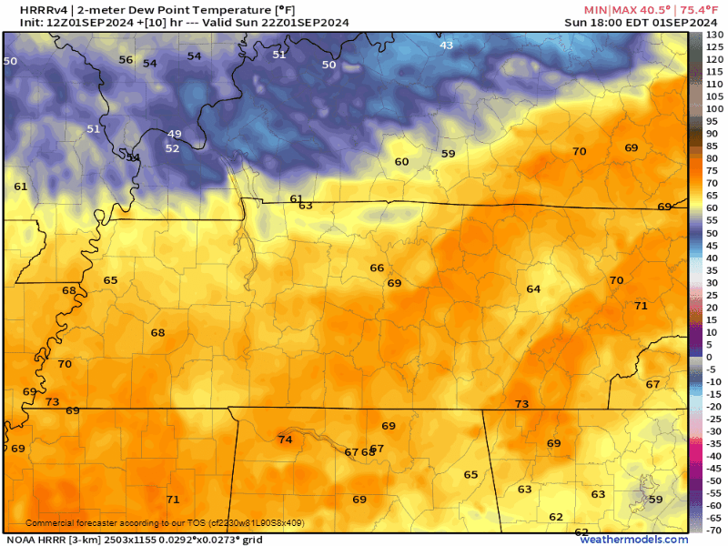
Line should clear around 5 PM north of Nashville and by 7 PM south of 840.

Storms are possible throughout the day, but it’s unlikely to turn into anything meaningful. Despite the clip art below, the bigger story is the heat.
High 90’s possible all day Saturday. Slight lower temp and storm chance on Sunday and Monday. The good news is most of us will experience a great albeit hot Labor Day weekend.

Showers/storms in the vicinity should slowly diminish over the next few hours.
Could be wrong, but this run of the HRRR think FNL and any other outdoor plans should be rain-free. Having some rain gear handy won’t hurt though.
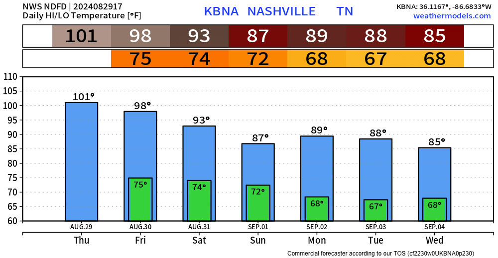
BNA has yet again reached 100° today, making it three straight days of 100° – the first time we’ve done that since July 2012.
The daily high temp for BNA is 101° today, and we may very well tie or break that.

As of 2pm, BNA has already reached 101° and we may end up getting a few degrees hotter. The daily record for Aug. 28 is 103° set in 1990 – we’ll see how close we get.
Our forecast high for tomorrow is 101° – if we do get there, it’ll be the first time since July 2012 that BNA has reached 100° three consecutive days.

Today is the first of potentially 3 consecutive days of reaching 100°. BNA has already gotten there today.
High temperatures are expected to get to 102° Wednesday and 101° Thursday.
If we do end up reaching at least 100° in these 3 consecutive days, it’ll be the longest such streak since 2012, when we reached 100° 4 days in a row from June 28 – July, and then 5 days in a row from July 4 – July 8.

So far today our high temperature has been 99° at BNA and is expected to get into the triple digits over the next several days.
However, our saving grace will be dewpoints – only expected to be in the low to mid 50s, which will keep the heat index value very close to what the actual air temperature is. Regardless, it’ll still be hot – but it could be worse!

The NWS Nashville office made this neat graphic to show the chance of temperatures getting to at least 100° this week. Our highest chances will be Tuesday – Thursday, when we could very well get to the century mark 3 days in a row.

I bring very little good news.
Monday – Friday look to be the hottest with temperatures near or at 100 degrees daily.
Thankfully dewpoints will be tame enough to where our heat index values should stay below Heat Advisory criteria. But regardless, it’s gonna be hot.
You must be logged in to post a comment.