
We should get some fairly efficient melting of anything that is still hanging on. We’re on our way to highs in the low 50s, with some rain coming this afternoon.
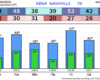
HRRR model gives a guess on how things play out, with rain starting this afternoon, lasting thru this evening.


You must be logged in to post a comment.