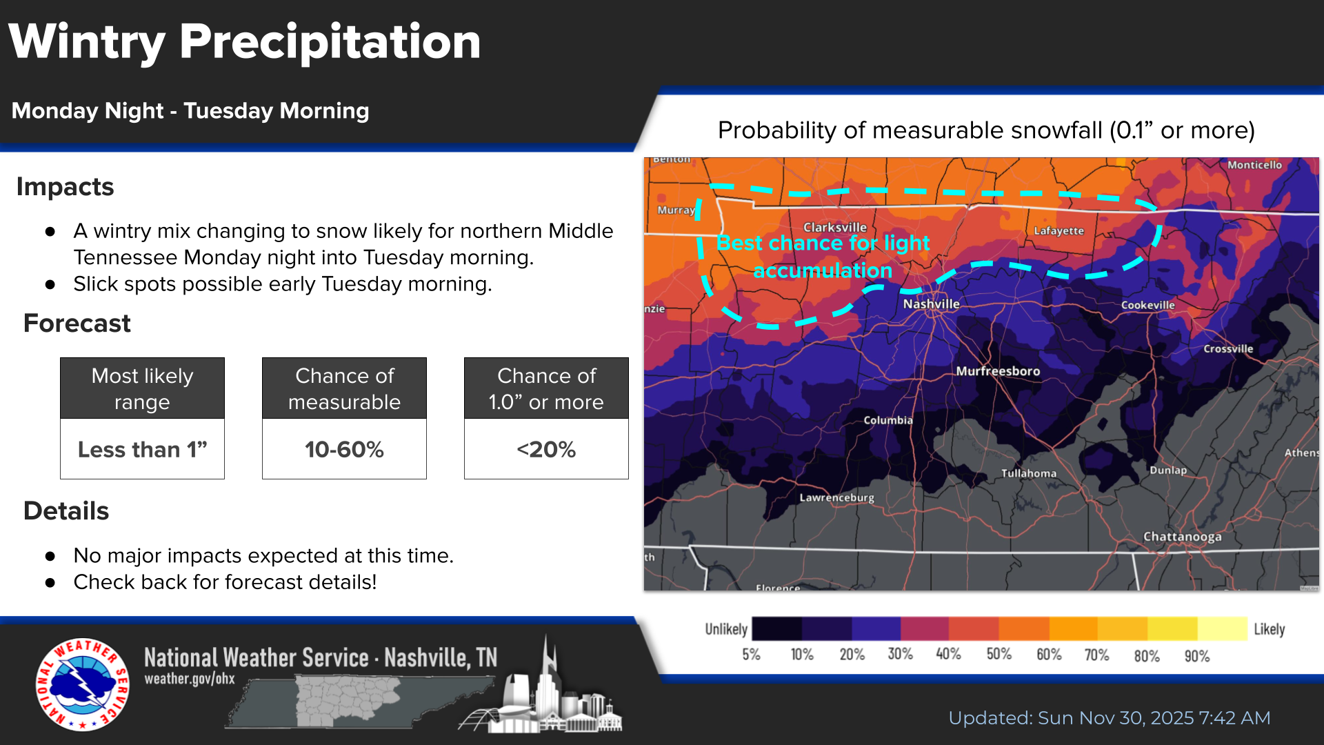
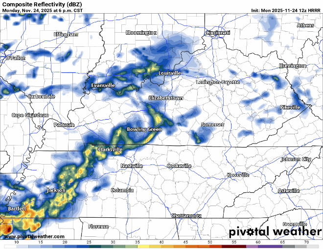
Mostly Dry Weekend, Cooler Temps Eventually Coming

Hot this weekend with temps in the low 90s. Fall officially arrives at 7:43p on Sunday, but it won’t feel like it. “Fall-like” temps hold off until middle of next week.

Low chance of a shower this weekend. Most of us stay dry, but a few of us could get a quick shower. NBD – no need to alter outdoor plans. read more

Very Low Chance of a Shower This Weekend

Above-average temperatures will continue thru the weekend, getting back to around average by the middle of next week.

The transition of seasons never goes smoothly around here.

Some of the CAMs have introduced a very low chance of a stray shower passing this weekend, most likely in the afternoon and evening. I see no need to alter any outdoor plans, but just more of a heads up – majority of us will stay dry and hot. read more

Drought Continues to Drought

No improvement with today’s drought monitor update, as both our counties continue with a Moderate to Severe Drought.

Drought conditions are expected to worsen as very little rain is in the forecast. read more

Patiently Waiting for Cooler Weather

While the temps haven’t been just unbearable, it just doesn’t quite feel like Fall just yet. And it won’t over the next several days.

Starting tomorrow (Thursday), we should see afternoon high temps reach 90° several days, including this weekend, adding onto our already above-average total of 90°+ days in 2024. read more

Above-Average Temps & No Meaningful Rain in the Foreseeable Future

High temps slowly climbing to the low 90s by this weekend, about 10° above average for this time of year (82°).

Dewpoints will be in the low to mid 60s, so those low 90s won’t be unbearable.

Unfortunately, still no meaningful rain chances to talk about. Rain might come back in the forecast by early to mid next week, but too soon to tell. read more

Consistent Weather Thru The Week

The entire blog could really be summarized into: warm & dry. I could just leave it at that – but I won’t.

No measurable rainfall is expected over the next 7 days. Can’t totally rule out a quick sprinkle on Tuesday or Wednesday, but think those chances stay confined to the Plateau. read more

Dry & Warm on Repeat

No real rain chances in over the next 7 or so days.

Maybe a light shower on Tuesday or Wednesday from PTC #8, which could become Helene tomorrow. Mostly a rain-maker for the Carolinas.

Temps just slightly above average thru the week. read more

Lingering Showers Today, Dry Week Ahead

Bright side – we have avoided any severe weather or flooding issues.

Not-so-bright side – we haven’t received much rain to help with our drought situation.

Latest HRRR model (above) shows the main axis of rain staying to our SW most of the day, with a few showers coming up to our neck of the woods – especially around dinnertime. Models have not been the best the past few days, so be sure to keep an eye on the radar if you have any outdoor plans – you can always check the radar on our website here. read more

Local Flood and Isolated Tornado Threat Thru This Evening, Lingering Showers Possible This Weekend

Thus far rainfall totals have been extremely disappointing, but the threat is not quite over.

NWS Nashville has highlighted an area of concern for a local flood and isolated tornado risk which includes most of WillCo. This does not mean Nashville and Davidson Co. are in the clear, but the main area of focus will be inside the red circle. read more

Watching the Heavy Rain Potential and Low-End Tornado Threat

Rain from now Tropical Depression Francine is moving in and will increase in coverage throughout the day.

The latest HRRR model shows heavier rain later this afternoon, continuing into tonight.

Friday is where some uncertainty comes in. read more