

Blerg conditions are met when temperatures are below 40 degrees, no snow, no sun. Officially, the forecast high temp is 41 at BNA. I dunno that we’ll get there. Blerg.
Temps hit 50 degrees for Saturday and Sunday ahead of our next system. 🎉

Blerg conditions are met when temperatures are below 40 degrees, no snow, no sun. Officially, the forecast high temp is 41 at BNA. I dunno that we’ll get there. Blerg.
Temps hit 50 degrees for Saturday and Sunday ahead of our next system. 🎉

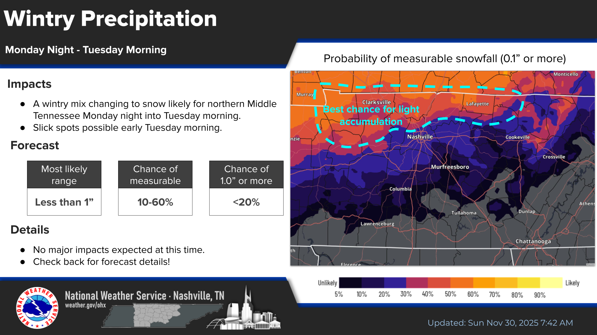
Light precipitation begins late this afternoon, continues until after midnight. We expect the margins to be razor thin with this event as to exactly which type of precip occurs where you are. Generally speaking, the chances for all rain and no impacts are highest in S Williamson Co, and the chances for a mostly sleet/snow mixture with temps reaching 32° or below are highest in N Davidson. A mix of sleet, snow and rain will likely exist in between and may go back and forth multiple times. Could even see some freezing rain mix in at times, especially in the higher elevations of W Williamson Co.

We were on Blerg Watch today, but since the sun peeked thru, we never reached the criteria. This is probably a good thing; Blergs are no fun.
The main talk for this blog will be our chances of some wintry precip Thursday night/Friday morning. This also looks to be a challenging forecast.

A really gross day today. Temperatures have actually dropped throughout the day; our high temperature of 38° occurred right around midnight. We were very close to achieving Blerg status today.
Blerg:
We did have some rain last night in the early morning hours and even some flurries being squeezed out today – so not officially a Blerg.

Not much has changed regarding our very low chances of some wintry precipitation tonight.
Very little to no impacts are expected.
This is our classic cold air chasing precipitation as it exists the area – the scenario that almost never works out for snow lovers. This is very likely one of those that leave snow lovers disappointed.
Some mist continues to stick around for the morning hours but should clear out here sooner than later. High temps will only reach ~40°. Prepare to bundle up if you are heading out to the Titans game, any other outdoor plans.

We’ll be dry until this afternoon when a gross, cold rain will move in.
Latest HRRR model think rain starts ~5p, continuing on/off thru the overnight hours.
Majority of the rain should be gone by sunrise Sunday morning. Titans game, any other outdoor activities will be dry but cool as highs only reach the mid 40s.

Plenty of sun today, unfortunately, that doesn’t mean warm. High temperatures will only reach the mid 40s today. It will be a very chilly shopping day.
Another cold morning will be in store for Saturday, with high temps a little bit better in the low 50s.

Happy Thanksgiving! We’re thankful for all of you – cheers to you.
The abundance of sun will be a bit misleading today as temperatures will stay chilly throughout the day. Highs will only get into the mid 40s. Definitely will need a jacket for any backyard football games or if you are in charge of deep frying the turkey.
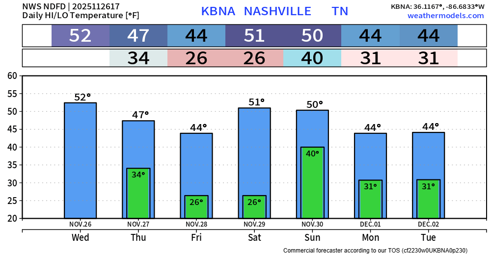
Yesterday our high temperature was 70° – we won’t be anywhere close to that for the foreseeable future. But to be fair, it is late November.
Dry but cool temps today. In fact, most of the US will be dry today, good news for those flying or driving on the so-called busiest travel day of the year. If you won’t be in town this holiday, you can always check the forecast for wherever you may be by going to weather.gov and typing in the city/zip code for a detailed forecast from the pros at NWS.
You must be logged in to post a comment.