Still a relatively hot weekend, but the dewpoints have relaxed a tad – causing our heat index values to feel pretty close to what the actual air temp is.
Thanks to a high-pressure system – we won’t have any rain chances to deal with this weekend.

Still a relatively hot weekend, but the dewpoints have relaxed a tad – causing our heat index values to feel pretty close to what the actual air temp is.
Thanks to a high-pressure system – we won’t have any rain chances to deal with this weekend.
Bad humid today and tonight. Dewpoints in the low 70s.
Isolated pop up storm possible mid/late afternoon. In a random, mysterious spot.
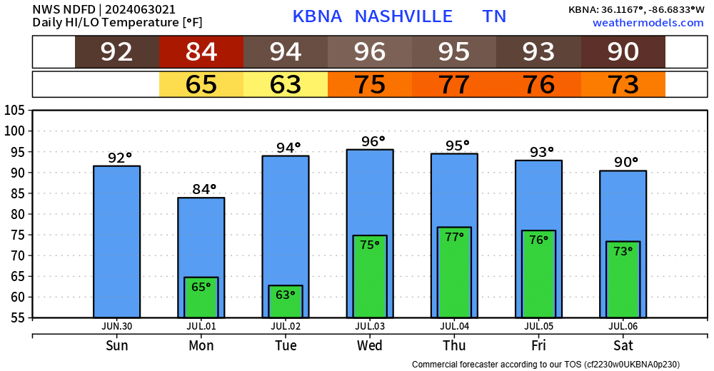
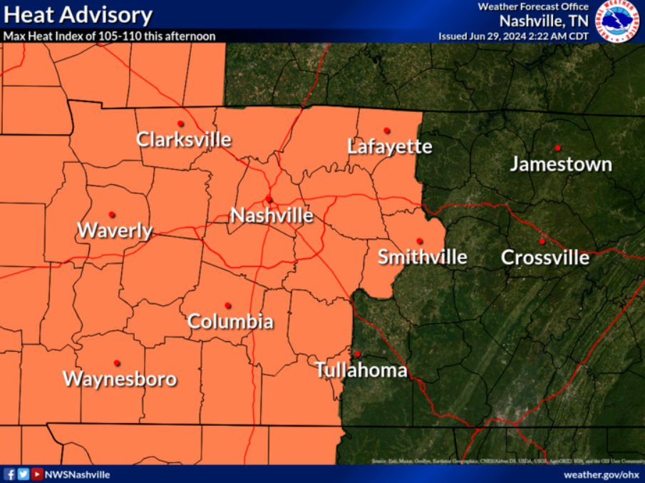
High today 97° + high dews = 104° max heat index. Heat Advisory in effect. Dewpoints will drop Friday night into the weekend. Still humid. Just not as bad as today.
Two main headlines for the next couple of days.
First up, the heat.
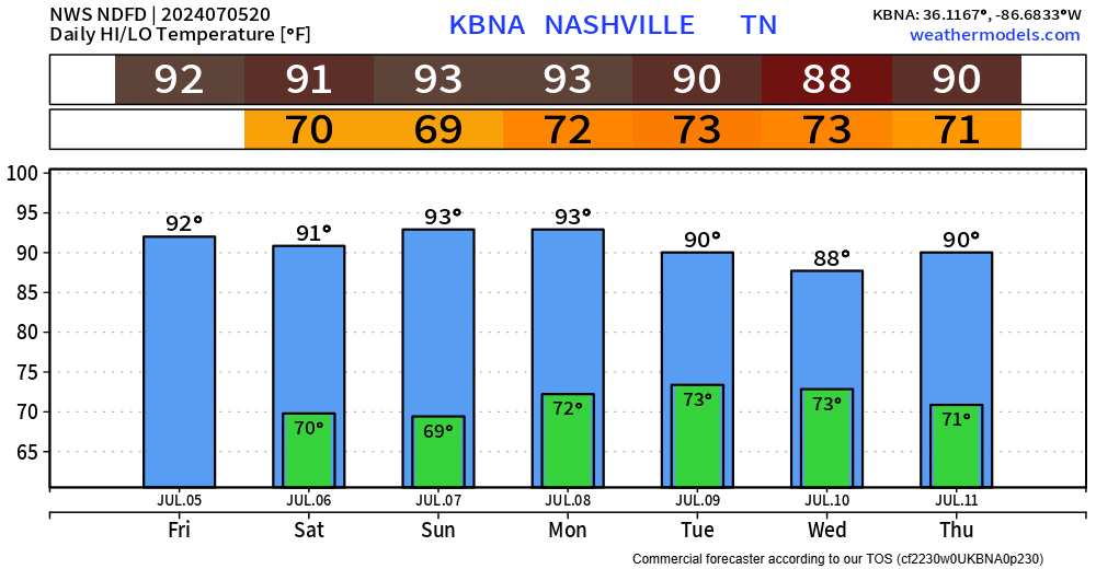
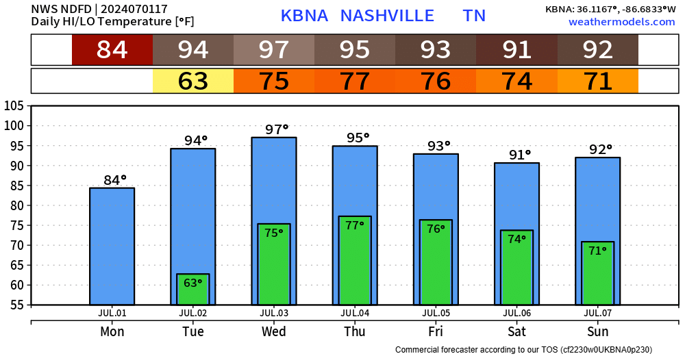
The nasty one-two punch of air temps in the mid to upper 90s, and dewpoints in the mid 70s will lead to these heat index values shown above today and during the 4th.
The heat and humidity has return and will stick around for a few days. Heat index values will be around the century mark today.
Tomorrow the heat and dewpoint combo will turn up just a bit further, sending heat index values past Heat Advisory criteria.
Spectacular weather for the first day of July.
Unfortunately, this amazing weather will be short-lived as the heat starts to turn back up tomorrow.
We quickly return to the 90s tomorrow and will stay there for the remainder of the week.
A few more isolated showers/storms are possible tonight, but I think most of us stay dry.
Monday will be the day of choice to get any yard work done. High temps only in the mid 80s and dewps in the mid 50s.
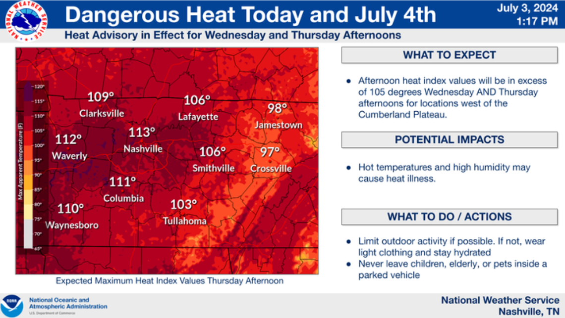
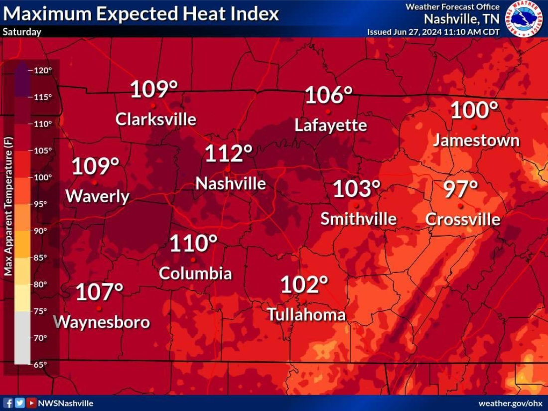
Heat index values up to 110° will be possible this afternoon and evening.
Air temperatures in the mid to upper 90s, combined with dewpoints in the mid 70s, will make for a sweat fest.
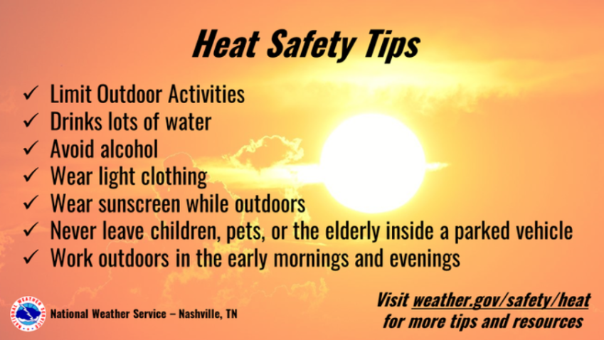
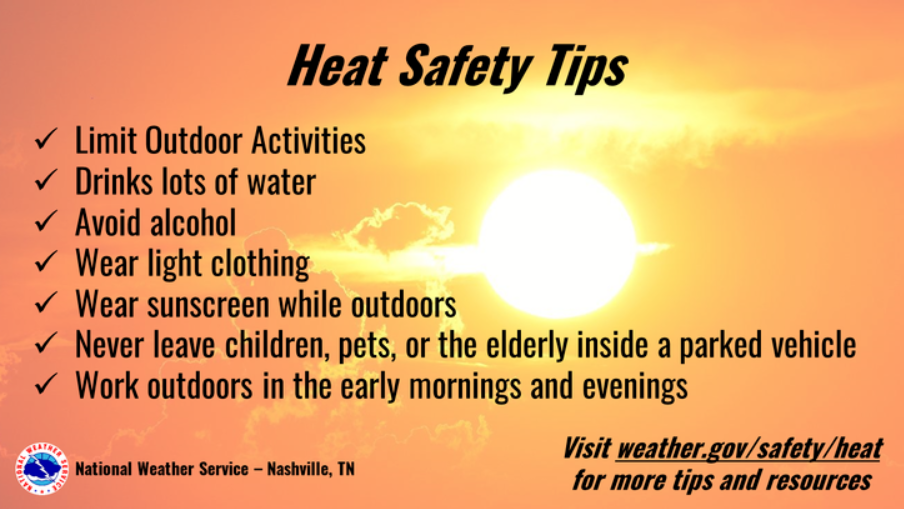
If you must be outside, be sure to take it easy. Take breaks in the shade (or even better A/C) and drink plenty of water. Never leave kids or pets in a car.
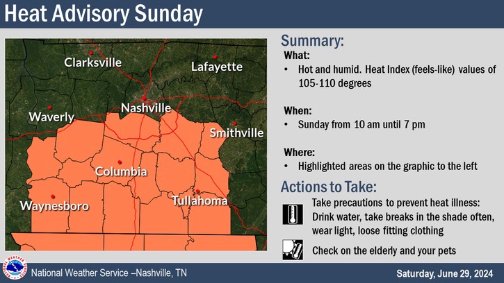
In addition to our Heat Advisory today, Williamson Co. (Davidson excluded) is included in another Heat Advisory from 10am to 7pm on Sunday.
Very low chance of us seeing a shower/storm today to help cool us off. In the off chance we do, heavy rain, lightning and gusty winds will be possible.
Better chance Sunday, still not great though.
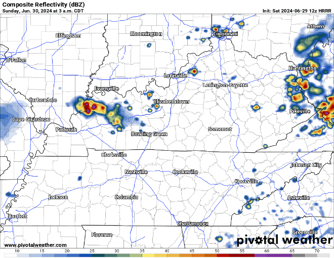
HRRR model shows a batch of showers/storms moving thru around sunrise Sunday, with a dry rest of the day. This could change, but good news for any outdoor plans.
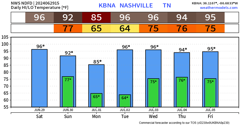
Monday will feel great compared to…every other day in the forecast. Temperatures quickly turn right back up.
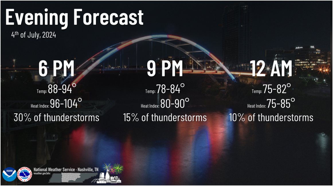
"...heat index values above 100 including for the 4th of July
Holiday. Starting Tuesday night we will also see very warm
overnight lows in the mid to upper 70s, this will bring little to
no relief to those without air conditioning. Forcing will be weak
during the week but with the high dew points popup afternoon and
evening thunderstorms will be possible each day staring Wednesday." - NWS Nashville AFD
Today is hot – tomorrow will be hotter.
Our temp/dewpoint combo today is low 90s/low 70s.
Tomorrow, we get upper 90s/mid 70s. This will send heat index values (aka “feels like” temp) into the 105° – 108° range.
Today will be the day to get any yardwork done before the weekend.
Friday will be hot, but Saturday will take the cake.
With heat index values reaching into the 105° – 110°+ range, it will be downright brutal.
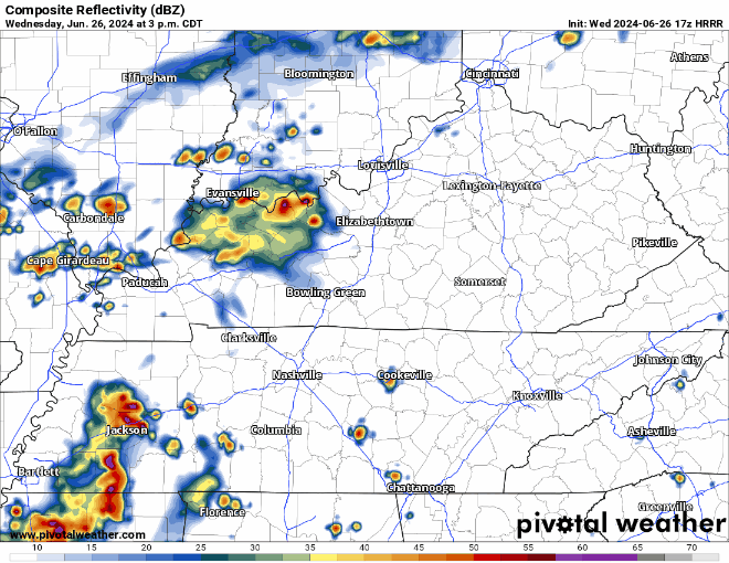
We’re still dealing with the low probability (5% chance within 25 miles) of damaging straight-line winds and hail.
Timing wise, we are still looking at a timeframe of late afternoon into the evening – shown below by the HRRR model.
You must be logged in to post a comment.