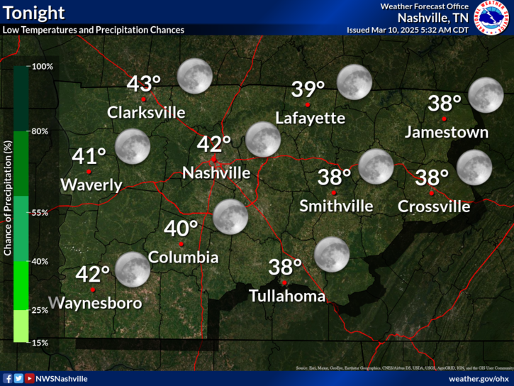
Not Again! (Tonight...and Monday?)

Current Radar 

Tonight – A Little More Snow

As you can see from the above radar, a long, narrow ribbon of snow continues to drive down I-24.

Dry air aloft, personified by the Dry Air Monster, has been eating (evaporating) some of the precip, but not all of it. If you have a window, you can verify. The DAM hasn’t been hungry. read more

Watching Another Clipper Tonight

Current Radar 

Today – More Rain or Snow? High: 30°

We’ve got sunshine, which will aid snowmelt.

Rain, but more likely snow, is possible tonight.

We are watching this clipper move our way: read more

Cold Night Ahead

Current Radar 

TONIGHT – 26° by 6 PM

Snow will be ending this evening!

Lows will drop to around 15° overnight.

Yeah. That’s cold.

Winds will stay in the 5-10 mph range, knocking “feels like” temps into the single digits. That’s very dangerous if you’re not dressed properly. read more

Snow!

Current Radar 

UPDATED for Winter Weather Advisory for Davidson & Williamson until 6pm Tuesday evening.

wwa

Temps will continue to drop overnight. By midnight, everyone should be in the 20°s, on our way to 24° just before sunrise Tuesday morning.

Meanwhile, this clipper system continues to rotate light, scattered snowshowers into Middle Tennessee. read more

Light Snow Tonight/Overnight As Temps Tumble Into the 20°s

Current Radar 

Temps Dropping Tonight

Some of the coldest temperatures of the winter are arriving tonight.

One cold front swept through early this morning, and another is pushing in very cold air now.  However, during the day, temps here on the surface will remain above freezing, slowing dropping toward freezing around 9 PM or so tonight. Stay tuned on Twitter to verify the timing of this. read more

Still Thinking Less Than 1″

Current Radar 

A Little Light Snow

as I write this, we are slowly dropping out of the 50° range. Temperatures will be in a freefall until they finally bottom out around 24° early Tuesday morning.

Two cold fronts are coming. read more

Monday-Tuesday Snow Update: Less Than 1″

Current Radar 

Overview

Sunshine will bring 55° this afternoon, but clouds will arrive tonight. Arctic air arrives Monday and Tuesday while a clipper system brings rain and a little snow.

Chronology

Sunday. A cold front will arrive late tonight or early Monday morning. The HRRR model thinks it’ll enter NW Middle Tennessee well after the Super Bowl, getting to us probably before midnight. read more

Decent Weekend. Snow/Flurries Monday, But Not A Big Deal

Current Radar 

The Weekend – Not Bad!

Just below freezing in the morning, then warming into the mid-50°s while clouds arrive Sunday after dark, announcing our next system.

Things Get Interesting Sunday Night – Monday Morning – Monday Night

A big trough of arctic air will begin its approach. By midnight Sunday evening, it will have already started its push into Middle Tennessee. read more

Nice Weekend; Snow Chances Mon-Tue Look Meh

Current Radar 

TONIGHT – 43° by 6 PM

Not as cold as last night.

SATURDAY – Sunshine, Few More Clouds – Wake Up: 29°, High: 51°

A “moisture-starved shortwave” arrives, delivering only morning clouds, and, you guessed it, no rain.

More clouds show up Saturday night, which will trap the “heat” and keep the low temp from dropping too far. read more

Sunny & Cool Headed Into the Weekend

Current Radar 

TONIGHT – 38° by 6 PM

Clear skies overnight and pretty calm winds will help temperatures to fall a good bit.

We’ll be waking-up to the mid 20°s tomorrow morning.

FRIDAY – Wake Up: 25°, High: 50°

Tomorrow will be equally as nice, as high pressure settles-in to our west: read more