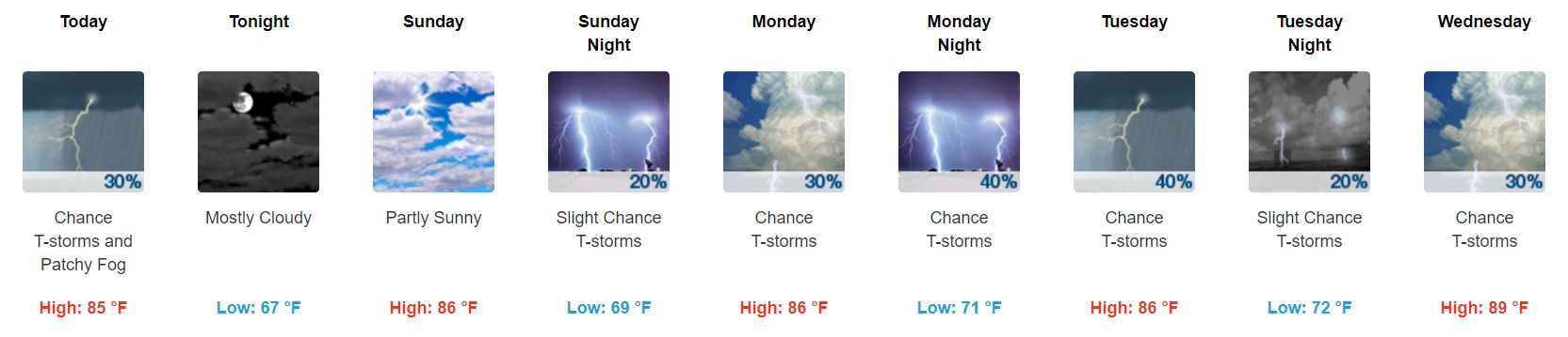
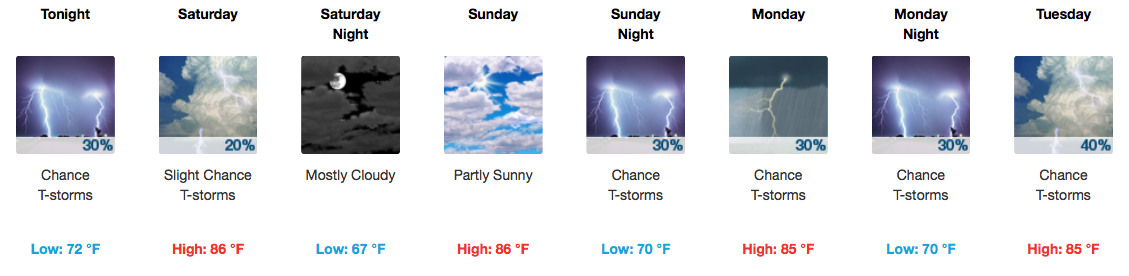
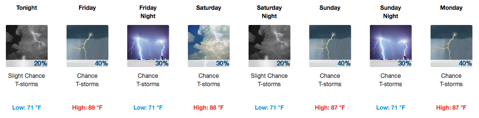
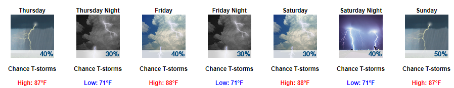
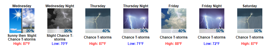
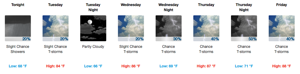
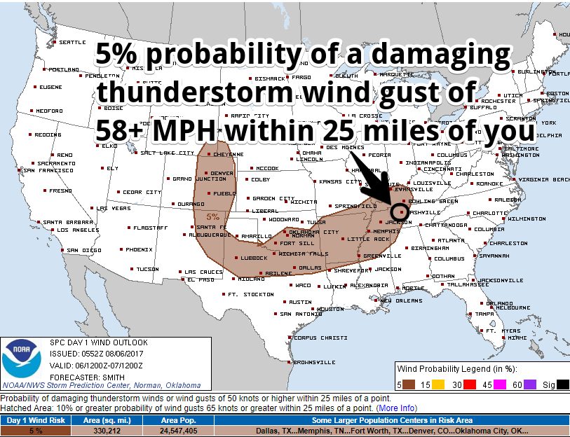
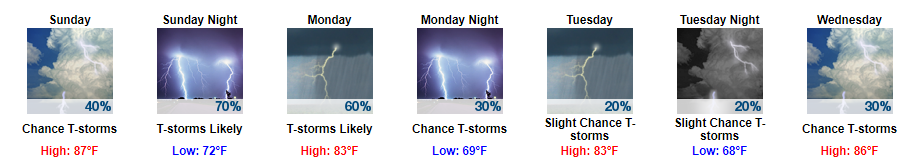
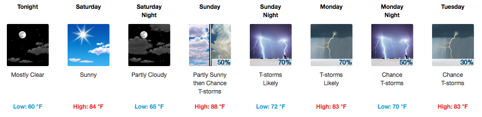
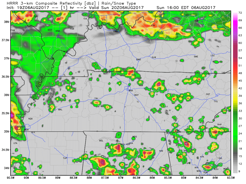
Snow Q & A

There are Two Chances for Snow over the next 24 hours.

Chance #1: Thursday, From Now Until 9 PM

Should You Panic? No.

Why Not? Most of it looks like it will go north of us.

Our current radar also shows the majority of it skating across the southern Kentucky border which is what the HRRR model below thought it would do. read more

Two Rounds of Snow Chances, One Today, One Friday

Current Radar

There are two chances for very light snow accumulations today and tomorrow. One-quarter to one-half inch of snow total, with only minor travel problems.

Round 1 — Today: Winter Weather Advisory Begins at Noon, Chance of Snow the Rest of the Day

First things first, our Winter Weather Advisory that covers both Davidson Counties and Williams Counties goes into effect today at noon and will last through midnight tonight.

Here is the text of the advisory: read more

New Model Data Has Arrived To Add More Confusion & Uncertainty

Tonight – Super Chill Forecast

Clouds are increasing. Tonight is just another cold night. The Winter Weather Advisory is not for tonight.

Winter Weather Advisory from Thursday at Noon Until Thursday at Midnight

Current expectations: under 1″ of snow

Mixed model signals betray any meaningful confidence in the forecast

Here’s the text of the Winter Weather Advisory:

national-weather-service-watch-warning-advisory-summary-google-chrome-2017-01-04-16-10-19

This advisory DOES NOT MEAN we will get a lot of snowfall. We are currently expecting up to one inch but will likely see less than that. A dusting appears more likely. read more

Winter Weather Advisory Details, Timing, & What Might Go Wrong

Tonight – Super Chill Forecast

Clouds are increasing. Tonight is just another cold night. The Winter Weather Advisory is not for tonight.

Winter Weather Advisory from Thursday at Noon Until Thursday at Midnight

Current expectations: under 1″ of snow

Here’s the text of the Winter Weather Advisory:

national-weather-service-watch-warning-advisory-summary-google-chrome-2017-01-04-16-10-19

This advisory DOES NOT MEAN we will get a lot of snowfall. We are currently expecting up to one inch but will likely see less than that. A dusting appears more likely. read more

Calm Today, More Discussion on the Snow Potential Thursday

Relatively Quiet Today and Tonight

Crisp, cold, winter air has arrived and looks to stay through the remainder of the week. Overnight we had our first front swing through the area, bringing in those cooler temperatures with it.

We will start the day today with a few leftover clouds that are currently pushing out of our area. By lunchtime, we should begin to see those partly sunny skies if not before then. read more

Some Snow Possible With A Cold Snap

A Nod to Mr. Bobby Boyd

You probably don’t know him. Mr. Boyd has worked over 50 years in public service to this community as a forecaster at the NWS office in Nashville. He didn’t want a big deal made of his retirement, so if I can presume to speak for Nashville and all of Middle Tennessee, I’ll leave this here simply with a sincere “thank you.” read more

Maybe a Little Snow, Definitely a Lot of Uncertainty

A Nod to Mr. Bobby Boyd

You probably don’t know him. Mr. Boyd has worked over 50 years in public service to this community as a forecaster at the NWS office in Nashville. He didn’t want a big deal made of his retirement, so if I can presume to speak for Nashville and all of Middle Tennessee, I’ll leave this here simply with a sincere “thank you.” read more

Rain/Storms Tonight; Update on End of Week Snow Potential

Rain, Maybe A Few Storms, Tonight

Rain Expected To Arrive By Mid-Evening

HRRR Simulated Radar Through 7 AM Tuesday

The Center of the Storm System Is Expected to Pass Right Over Us; The Potential for Strong/Severe Storms Should Remain to Our South

Strong and severe storms are only possible south of the low pressure (the red “L” in the above image) on days like this. Although we cannot rule out a strong or severe storm or two, I’m feeling no anxiety about the storms tonight. read more

Rain & Storms Today; Low Confidence in End-of-Week Snow Chances

Rain and Storms Today

Rain and strong to severe thunderstorms will race across the southeast today, but the worst of it will stay well south of us.

HRRR Simulated Radar through 11 PM Monday

It’s possible a strong thunderstorm or two will develop tonight, with the main threats being strong winds and hail.

The Storm Prediction Center has kept the tornado threat south of us:

What’s Happening?

A warm front is heading our way today. Temperatures and dew points will continue to rise. As this happens, lapse rates will grow, and so will rain-and-storm-supportive instability/energy. read more

Rain and Storms Tomorrow; End of Week Snow Chances

Drizzly, Foggy Evening

Today’s mist and light drizzle only registered a “trace” amount of rain in the official rain can at BNA. The fog and drizzle will continue tonight.

Monday Afternoon/Evening Rain & Thunderstorms: Severe Weather Kinda Possible

Temps and winds will increase through the day as we wait for the rain and thunderstorms.

ETA

The HRRR model says the morning looks pretty quiet:

We think rain will start mid afternoon.

Any storms would arrive after dark.

More storms would then be possible closer to midnight:

How Bad Will They Be?

The rain will not be continuous during the day. Expect a heavier, more continuous rain in the evening and overnight. Flooding is not a concern right now.

So, what are we talking about? A low threat of damaging winds and a tornado.

The above graphic applies generally to all of Middle Tennessee, not specifically to Davidson and Williamson Counties. Of course, it’s not a “low” threat if it happens to you.

The severe weather threat is higher the further south you go.

I’ve been through the guts of the data — the forecast soundings for you weather nerds — and I’m not impressed by the potential of this system.

This is a very-low-end concern right now. Expect this forecast to change, so keep an eye on the forecast today and especially tomorrow.

Arctic Air Arrives Wednesday; Snow Chance Thursday/Friday? Mehbe.

Tuesday’s high is 63°. Wednesday’s high: 35°. That’s some arctic air.

A reminder of what I wrote this morning:

Over the past several days, the GFS and Euro models have Drunk Uncled their way around this forecast, from 8" of snow on the ground to no precip at all, and everything in between. The models often do this 7, 6, and 5 days before an "event," and they'll continue to behave like this for the next few days. Putting snow on your roof requires dozens and dozens of very complicated things to come together at the exact same time, and the forecast models just aren't that good. They are getting better, but there is certainly room for improvement. read more