
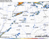
Our messaging has changed a bit, although not dramatically, from the past couple of days.
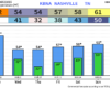
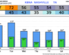
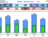
Long-story short [as possible], expected CAPE values (storm fuel) have trended up – mostly thanks to less cloud coverage than previous expected. This, along with sufficient shear (changing of wind direction/speed with height) has led the Storm Prediction Center to re-introduce low-end probabilities for severe weather. Although the threat is conditional, based upon several ingredients aligning.
You must be logged in to post a comment.