
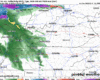
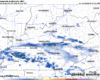
A line of storms is expected to arrive in our two counties in the 1-4 pm range, carrying a risk for damaging straight-line winds and possibly a tornado, although the risks are low. HRRR model from 11 am – 8 pm.

A line of storms is expected to arrive in our two counties in the 1-4 pm range, carrying a risk for damaging straight-line winds and possibly a tornado, although the risks are low. HRRR model from 11 am – 8 pm.

It will feel absolutely nothing like early March today. As of 11a we are already at 79°, likely on our way to breaking the daily record high of 83° – around 25° above average.
There’s a very low chance a quick shower passes thru this afternoon – but most of us will stay dry, if not all of us.
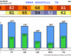
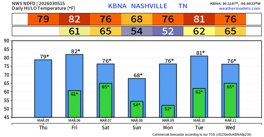
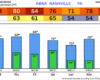
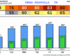
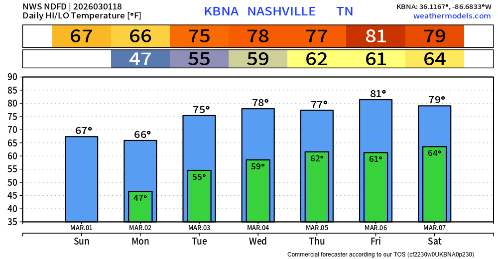
Our abnormally warm stretch of weather continues. Today (Thursday) and Friday both near 80°, which will threaten the daily high records. We “cool” down a bit on Sunday post-cold front, but warm right back up into the mid to upper 70s by early next week.
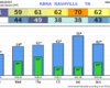
We’ll be on daily record temperature watch over the next several days, starting today.
Wednesday –> Forecast = 80° | Record = 84° (1976)
Thursday –> Forecast = 80° | Record = 80° (1910)
Rain should start to taper off this afternoon, clearing out by this evening. Clouds will hang around all day, keeping temperatures down all day. Today will be our “coolest” day for the foreseeable future.
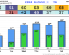
High temperatures will be well above average this week, nearly 20-25° above our average highs by the end of the week – threatening daily record highs.
How about that – groundhog.
Rain chances return early Monday morning, continuing on/off thru the afternoon. Just some light showers, with rainfall totals only around 0.25″.
Very nice weather ahead for this weekend – especially considering it is late February.
Highs in the mid 60s today and Sunday, we are treated with low 70s on Saturday. Mornings will still be fairly cool. No rain expected.
Fairly nice and mild thru the afternoon today – the sun will occasionally be able to peek thru the clouds.
Our rain chances return later today. The overall timing of the system has moved up a bit, with rain expected to move in around sunset this evening but moving out sometime Thursday morning.
Although it’ll be fairly chilly today – we do have a low-end fire danger today due to gusty winds and low relative humidity. Be extra cautious if you plan on having any sort of outdoor fire today.
Most of us have seen some flurries this morning. Those will continue to be possible over the next couple of hours – but no impacts expected, just cool to see. If you are snow-deprived, you can find some pictures from the Northeast, where from NYC to Boston they are experiencing a blizzard.
You must be logged in to post a comment.