It was a big day today.

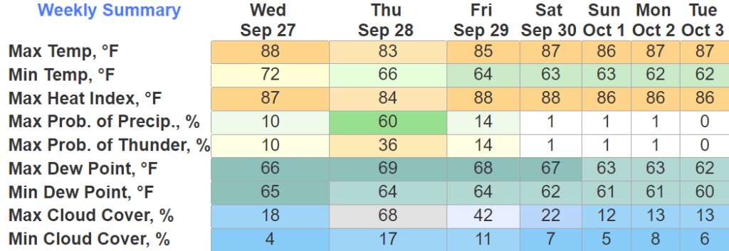
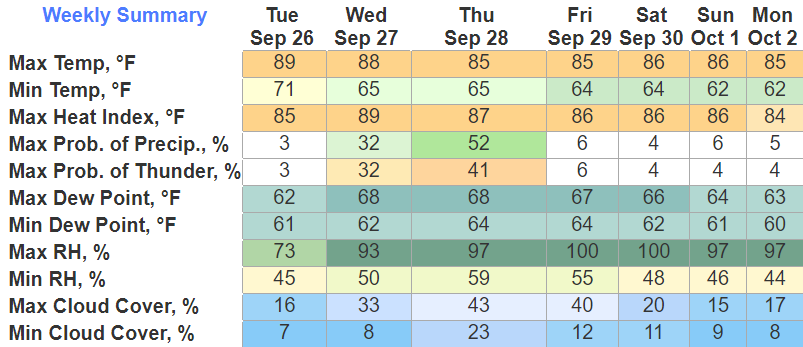
What she failed to mention is that it’s October 3rd and we experienced 88° for a high temp. Thankfully dewpoints were calm, so it did not feel horrendous.
Wednesday will be in the mid 80’s, with no rain chances.

It was a big day today.
What she failed to mention is that it’s October 3rd and we experienced 88° for a high temp. Thankfully dewpoints were calm, so it did not feel horrendous.
Wednesday will be in the mid 80’s, with no rain chances.
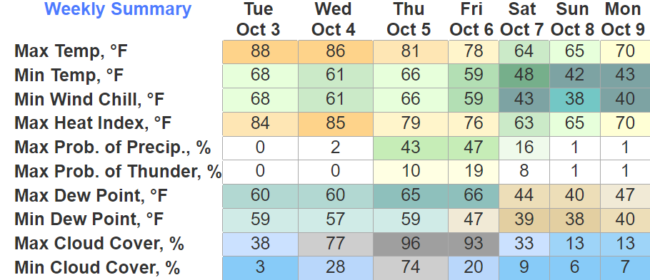
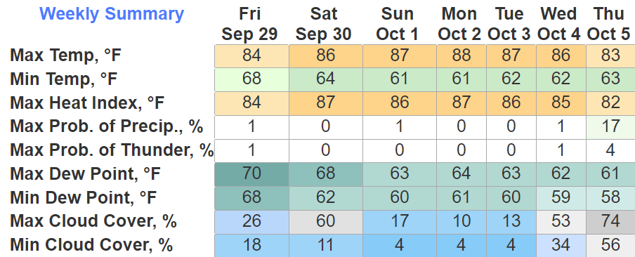
If you like warm weather, the first half of the week is just for you. Highs in the upper 80s, dewpoints aren’t miserable, no rain. Not exactly beginning of October weather tho.
If you like cooler weather, the back of the week has your name written all over it. A cold front will push thru Thursday/Friday bringing some rain chances and fall-like temps.
Not the most ideal start to the tenth month of year. High temps in the upper 80s, at least there is no rain chances?
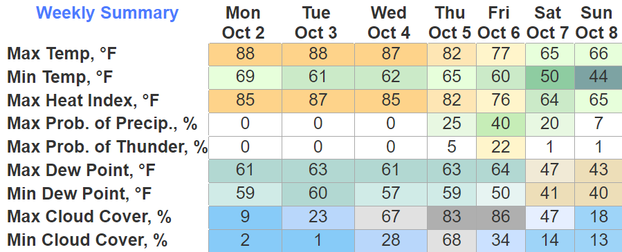
This dry, yet warm trend will continue thru Wednesday. Thursday is when change comes.
We have several more days to deal with the upper 80s before we get the real deal fall weather.
The next 5 days will basically be a repeat of each other, no rain, above norm temps with dewpoints in the low to mid 60s. Meh.
The rain we saw this morning will be the last we’ll see for a while. Rainfall totals range from 2″+ in Northern Davidson Co. to 0.06″ in far SE WillCo.
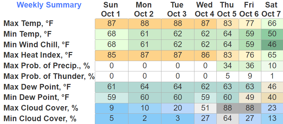
Next 6 days will be dry and not a lot like fall. High temps in the mid to upper 80s, with dewpoints in the mid 60s. Not the most ideal end to September.
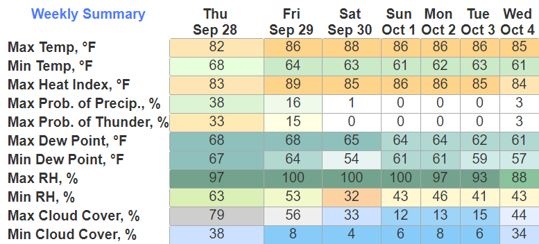
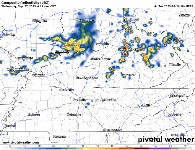
Some of us, especially Davidson Co. saw some decent thunderstorms today, everything stayed under severe limits thankfully.
We get one more shot of rain overnight into Friday morning.
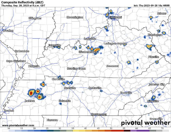
As shown above by the HRRR model, these would just be some quick showers, nothin’ crazy. Should be out of our neck of the woods by mid-morning Friday.
Some of us won the lottery today, while others missed out. If you missed out, don’t you worry, tomorrow is another day.

Tomorrow will have our best chances of the week, also our last chance of rain for the foreseeable future. No severe weather is expected, but some general thunderstorms are possible.
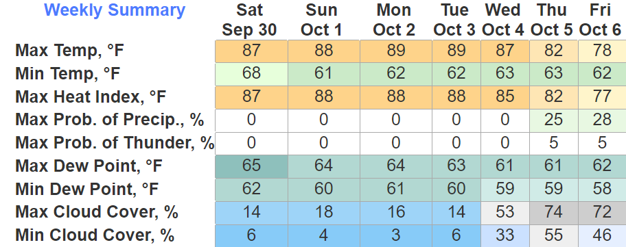
Dry day, but a warm day. BNA did end up reaching 91°. That’s about ten degrees above average, and just a little shy of the daily record high of 92° set all the way back in 1891.
Tomorrow we’ll once again get close to the 90° mark, but we’ll also have some rain/storm chances to deal with.
The maybe rain chances we had for today and Tuesday have diminished, as models have trended towards drier for us. Still can’t totally rule out a stray shower Tuesday. We’ll take it I reckon.
Other than an outside shot of some light showers this evening, the rest of your Sunday will be a-okay weather wise.
Rain chances increase as we get into the week. Not everyone will see rain, and those that do won’t see too much of it.
You must be logged in to post a comment.