
I mowed this morning – and can confirm, the grass is dry. Although I will say the cooler temps and shade was quite nice.
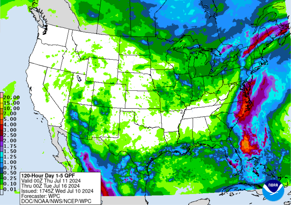
Rain chances today will be mostly confined to S of I-40. Not everyone will win.

I mowed this morning – and can confirm, the grass is dry. Although I will say the cooler temps and shade was quite nice.
Rain chances today will be mostly confined to S of I-40. Not everyone will win.
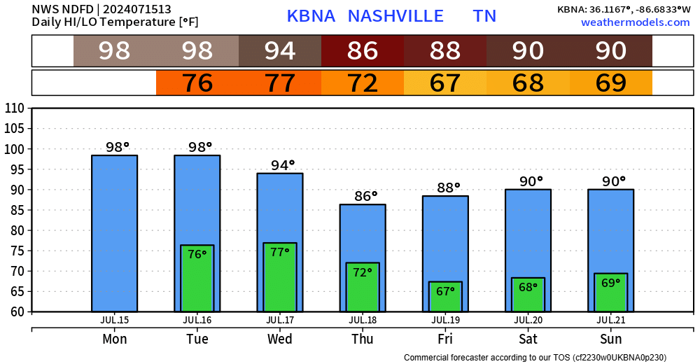
We shouldbe dry thru Friday night. Can’t totally rule out a couple of showers Fri PM, but most of us prob nothing.
Saturday, a boundary to our south will start to lift north, bringing the return of moisture and rain chances. These rain chances will stick around for a bit.
We finally get some “cooler” weather. Now, it’ll still be warm, but temperatures will be very much near-average.
Some much-needed rain will also be in the forecast.
HRRR model shows some storms popping up around 8pm or so tonight. Not totally sold on this yet, but it’s possible. A storm or two could have some damaging straight-line winds. But chances are very low.
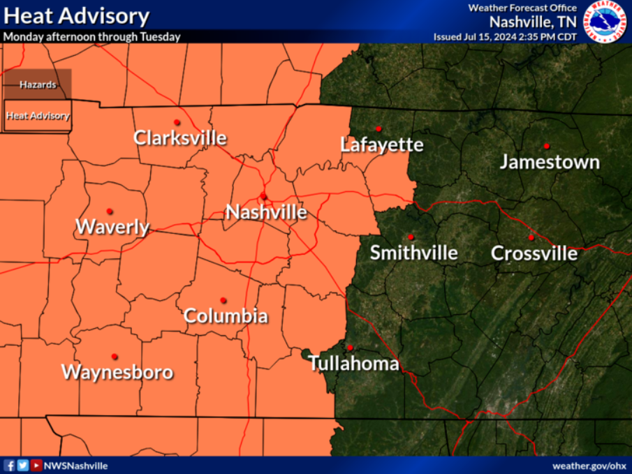
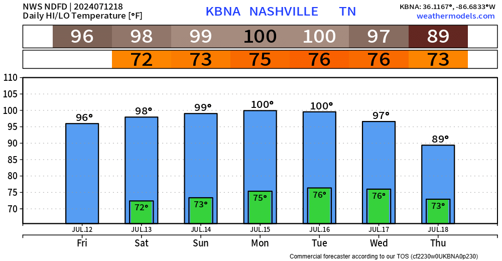
Even without the Heat Advisory, it’ll still be hot.
In hopes of cooling off, there will be an outside shot at winning the Wattery this afternoon/evening.
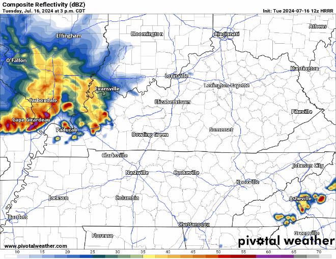
The HRRR model (above) shows the storm complex to our NW falling apart, with maybe some of us getting some rain. If a storm does surprise you, heavy rain, lightning and some gusty winds will be possible – but no severe weather expected.
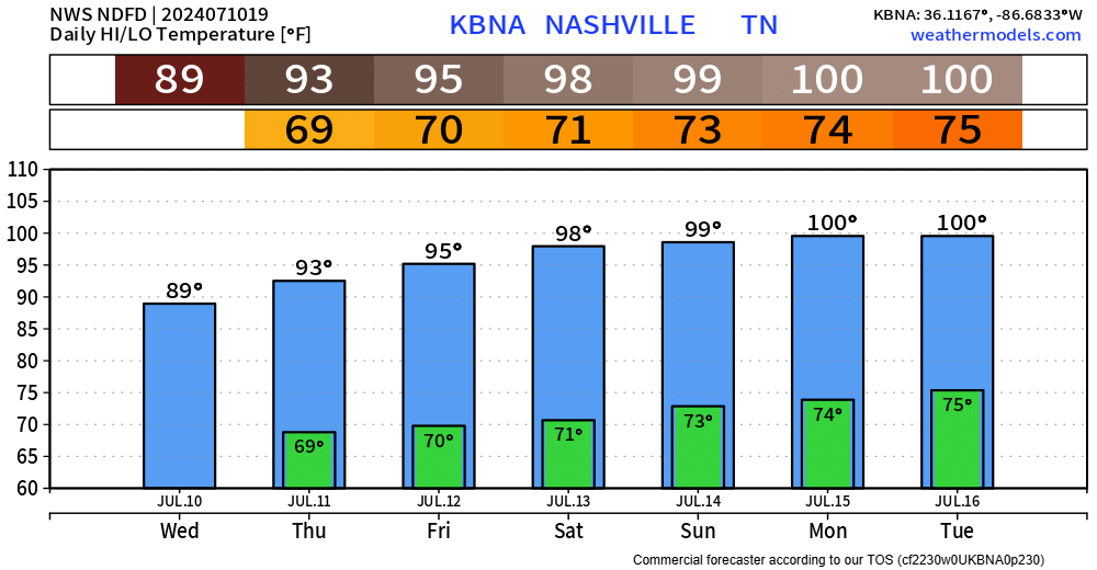
We did end up getting to 100° yesterday at BNA, fingers crossed we don’t repeat that today and tomorrow.
“…the last time we reached 100 two days in a row (at BNA) was just last year on August 24 and 25. If we get there today and tomorrow, that would be 3 days in a row. The last time we did that, we did it twice in one year: July and August 1990.” – NWS Nashville
The next 3 days will pretty much be a rinse and repeat, but hopefully we actually get rinsed by some rain.
Today, Monday and Tuesday all carry the chance of reaching the 100° mark, but regardless of upper 90s or the century mark – it’ll be hot.
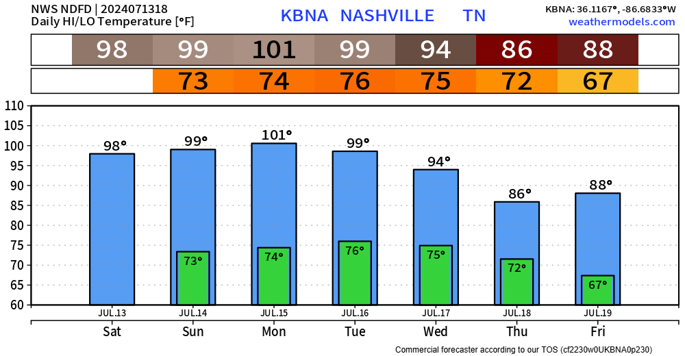
Finally have some good news to share, but first I’ll get the bad news out of the way.
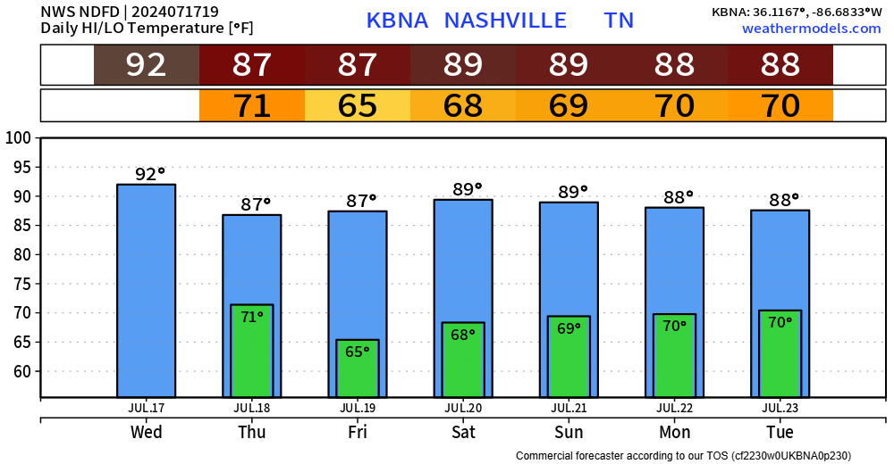
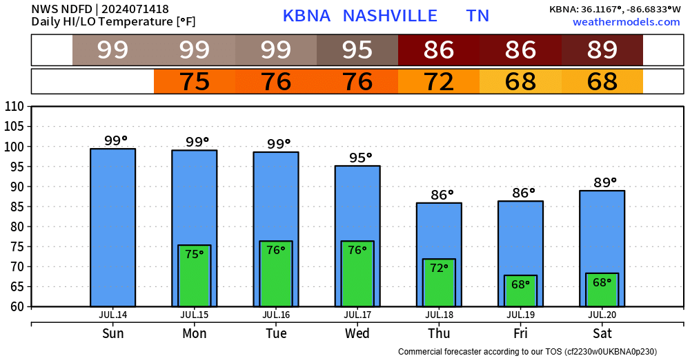
The next 4 or 5 days will be brutally hot.
High temps will be flirting with the 100° mark thru Tuesday.
It can be a bit challenging here to actually get to 100°, but we may make it. Our best chances will probably be Sunday or Monday. 99° or 100°, either way you’ll sweat.
It’s hot. High temps will be in the upper 90s thru Wednesday, maybe reaching the century mark on a day or two, but not much difference between 99/100 – it’s just hot.
Overnight lows in the mid 70s won’t bring much relief either.
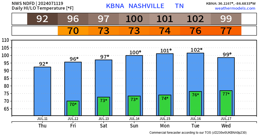
Not much else of a way to put it. The next 6 or so days look downright hot.
I suppose today will be the “coolest” day to do any yardwork?
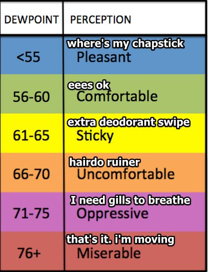
Dewpoints in the upper 60s thru Monday, when they turn up a notch into the low 70s for Mon – Wed.
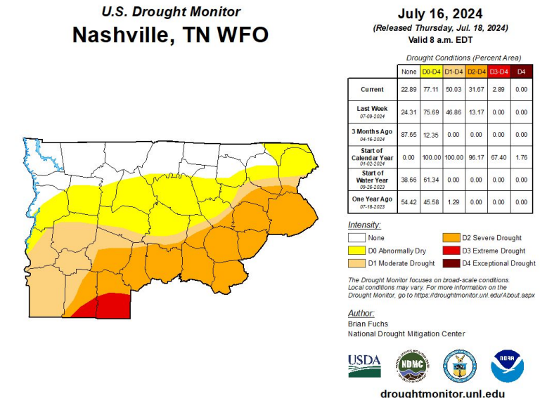
Good news is that most of us at least got a little rain yesterday.
Bad news is that there is very little chances at rain, if any, in the next 5 or so days.
Dewpoints will be in the mid 60s for the remainder of the week, making the heat not too sweaty.
You must be logged in to post a comment.