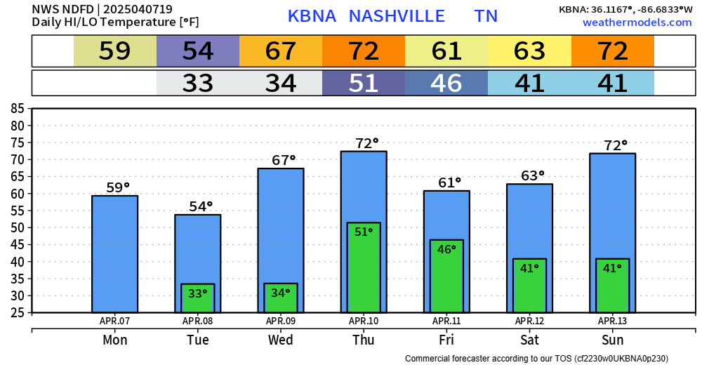
We’re still dealing with the low probability (5% chance within 25 miles) of damaging straight-line winds and hail.
Timing wise, we are still looking at a timeframe of late afternoon into the evening – shown below by the HRRR model.
Another hot one, but today some lucky folks will see a shower or storm to help cool things off.
HRRR model (above) demonstrates the potential for scattered showers and storms throughout the evening, with things quieting down after sunset. A few strong to severe storms cannot be ruled out, with lightning, damaging straight-line, and heavy rain being the main concerns. No tornado concerns.
Another very hot day is underway, thankfully the dewpoints have been relatively tame in the low to mid 60s, so heat index values are “only” hovering around 100°.
There will be no shortage of hot temperatures thru Tuesday. High temperatures in the upper 90s daily, possibly surpassing the century mark on Tuesday.
A few Wattery winners have already been chosen today, and a few more will be announced tomorrow, although chances look lower.
With any storm today or tomorrow, brief heavy rain, lightning and gusty winds will all be possible. A quick inch or so of rain is possible, while your friend on the other side of town gets nada.