HRRR is now in range for Tuesday’s potential severe weather. It’s showing a composite “significant tornado parameter” of around 1.0-1.5 Tuesday afternoon (blue). Anything over 1.0 gets our attention. All modes of severe weather remain possible Tuesday….large hail, damaging winds and tornadoes. More tomorrow as details become more clear. read more

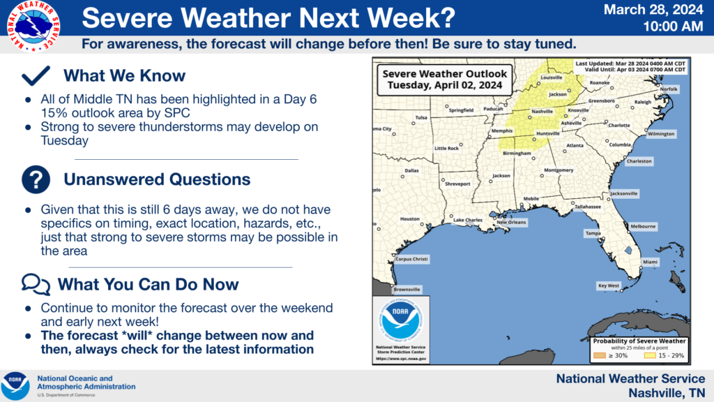
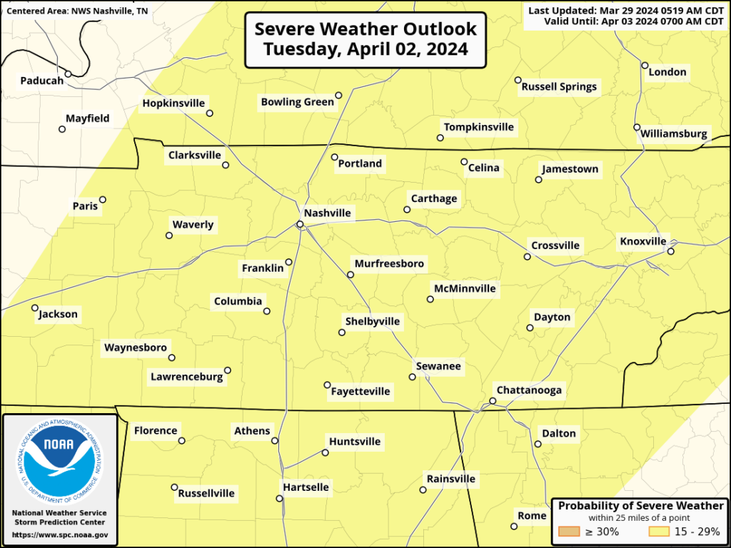
Discussing Tuesday’s Severe Weather Chances: Timing, Hazards...

Very nice Easter day going on.

Monday will be another warm and probably dry day. Overnight Monday we could see a few showers/storms, but the majority of the activity should stay to our north.

Our main focus continues to be the threat of severe weather Tuesday. read more

Concern rising for severe storms Tuesday. Damaging straight line winds, and/or large hail, and/or tornado.

Rough ETA Tuesday late morning until dark.

Review severe weather plans today.

Tuesday severe summary from NWS-Nashville: read more

Warm + Dry Weekend, Still Watching Tuesday.

Today’s high temps have soared into the upper 70s, Easter Sunday and Monday will be similar temperature-wise. A few places may even surpass 80 degrees.

We should be dry through Monday, a few showers cannot be ruled out Monday morning, but majority of us will stay dry. read more

Planters: another frost/freeze possible mid/late next week.

Beautiful Easter Weekend, Eyes Still on Tuesday.

Wonderful weather today and the rest of the weekend.

No rain expected thru Sunday, and we’ll likely stay dry Monday as well. Highs nearing 80° Saturday – Monday. Great weather for all the outdoor activities, egg hunting. read more

SPC continues to have us outlooked for the possibility of severe weather on Tuesday. Currently a 15% chance of severe weather within 25 miles of you. This will be revised in coming days.

Very Nice Easter Weekend, Watching Tuesday for Severe Wx Potential.

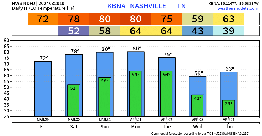
Lows will dip to around 40° tonight, a few places might see some frost but probably not.

Friday and the rest of Easter weekend will have some awesome weather.

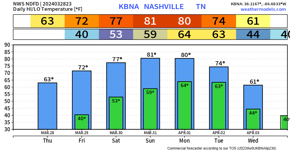
Friday and Saturday will have highs in the low to mid 70s, with Easter Sunday highs getting into the low 80s. Around 60° for any sunrise services. Monday a copy and paste of Sunday. read more

Watching early next week for some potentially bumpy weather. Few/no specifics available at this point. Currently, a 15% chance of seeing severe weather within 25 miles of you. Stay tuned.

Frost Advisory 3a to 9a Thursday, Rain-Free Until Mon/Tues.

Temperatures will get down to around 34° tonight, therefore a Frost Advisory will be in effect for early Thursday morning. “Frost could harm sensitive outdoor vegetation. Sensitive outdoor plants may be killed if left uncovered.” – NWS Nashville read more