Temps Still in the 90s, More Sunshine on the Way

Current Radar

Tonight: Clear Skies –  76° by 9 PM

Nothing but clear skies as we head into our Wednesday Evening. Perfect night to look at the stars if you are into that sort of thing.

Temps will fall pretty quickly once the sun sets, reaching the mid 70s by 9 PM before heading down into the mid 60s overnight. read more

Under (High) Pressure, Whole Week is Sunny and Dry

Current Radar

Tonight: Gorgeous Evening, Temps In the 70s

screen-shot-2016-09-20-at-9-05-04-amscreen-shot-2016-09-20-at-9-03-06-am

The temperature/dew point grids look great for a night outdoors with temperatures in the 70s by 7pm and the dew point in the lower 60s. Humidity levels will feel nearly non-existent compared to what we’ve had.

Overnight, we’ll drop down into the lower 60s!

Wednesday: Mostly Sunny, Very Few Clouds – Wake Up 63° High 89°

sky11_centmissvly

On a scale of 0-100%, we’re only expecting about 10% cloud cover on Wednesday. This means that much of Tuesday’s weather carries over…lots of sunshine and dry air over the region will make playing (or working) outside feel more “bear”able.

Extended Outlook:

screen-shot-2016-09-20-at-8-28-58-am

No problems in regards to rain, really through the entire week/weekend. Afternoon highs will top out in the low 90s with a gradual increase in clouds later in the week.

Those attending the Pilgrimage Festival this weekend should be in good shape! As long as our system out west isn’t *magically forecasted to speed up by about 36 hours*, Saturday and Sunday look fine.

Did You Know?

From NWS Nashville:

Nashville averages 47 days with 90 degrees and above. The most ever is 96 days back in 1954. The ranking goes like this for days 90 and above: 1954...96 most ever 2010...82 1980...82 2016...81 so far 1952...81 1941...81 1944...79 1953...78 1936...78 1925...78 1988...75 2007...74 read more

Plenty of Sunshine and Dry Weather Ahead

Current Radar

Tonight: Clear Skies – 9 PM 72°

Into tonight, those marvelous weather conditions continue as we head into the evening hours. Clear skies through the night with temps dipping down into the mid 60s overnight.

Tuesday: More Sunshine – Wake Up 63° High 90°

Did you like Monday? Then you’ll like Tuesday. Expecting for much of the same as we head into tomorrow. Only difference being that our high temps could get a little warmer than on Monday. read more

Quiet Weather-Week Ahead

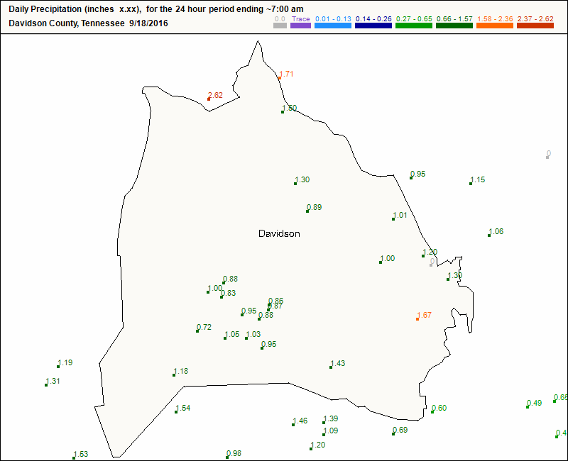
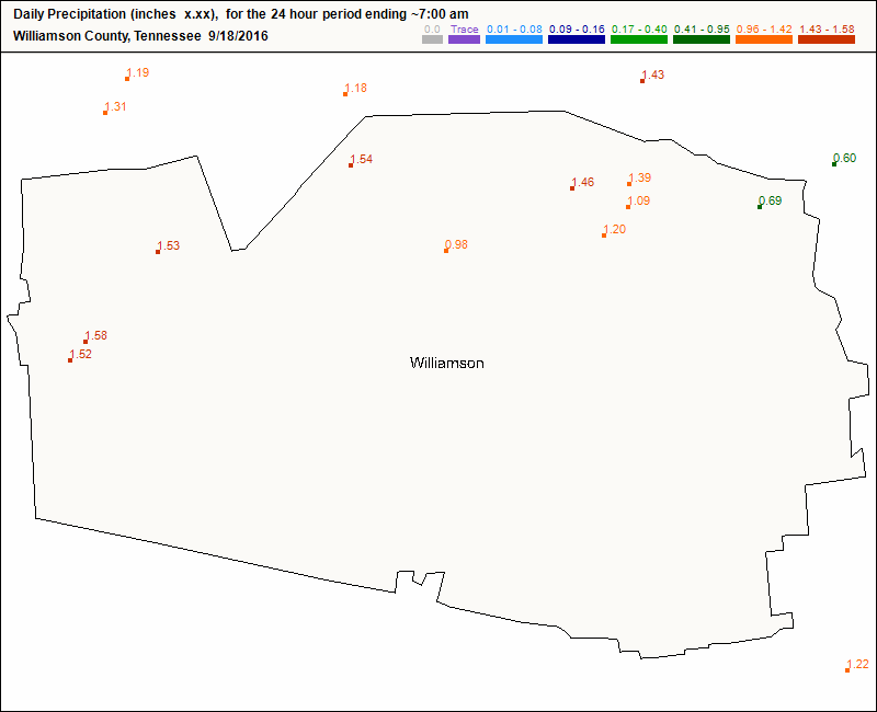
Rainfall totals from 7 AM Sat to 7 AM Sunday, via Cocorahs 

We may see a little rain overnight

Most of it is going south of us, but sometime before midnight, expect a little light rain to fall. The HRRR model illustrates:

Otherwise, we are shenanigan-free.

Sunny, with less humidity this week

Steady sunshine returns Monday. The dewpoint will stay in the low 60°s for more than 48 hours.

We will accept your “when’s it ever going to stop being so hot” complaints Thursday, when fall formally starts.

We’ll still get some summer weather

Looks like high pressure to our east late in the week will send us more heat and humidity for the weekend. And, yeah, there may be some rain, too. But, that’s to be determined. From NWS-Nashville:

Our next shot at rain could hold off until the end of next weekend as models are fairly consistent in showing a large upper level system pushing out of the Pacific Northwest Friday and its cold front reaching us by Sunday night or Monday of next week. However, even with the model continuity that far out, will carry only a chance probability of precipitation as this is Day 8 and things will likely change by the time we get there. read more

Rain Finally Leaving…Until Maybe Later Tonight

We got more rain overnight

Especially south of 40:

Storm Total Rain — West Williamson got the most

Again, this is likely an overestimate. We won’t know for sure until the Cocorahs data starts showing up with actual measurements.

I think the rain may be gone for today, but maybe not tonight

Rain and clouds are lined up along this purple line. This is an infrared satellite view, showing that the rain has finally moved east of us this morning: read more

Rain Continues, Dry Into Next Week

Current Radar

Tonight: Rain Chances Linger On

Your outdoor plans tonight look to probably get wet at some point. Currently have another bit of showers heading for the Middle TN region. Showers will continue to be off and on through the evening. read more

Rain Moving North Tonight, Stormy Saturday PM

Current Radar

Tonight: Rain Slowly Deteriorates, Temps in the 70s

Anyone who experiences rain later today will cool down immediately into the mid-upper 70s. Nice, right?

In case you don’t see rain, your temperature stair-step into the upper 70s will be a little slower, but we’ll get there. A comfortable night ahead in the temp. department, but it will remain humid. read more

Humid Tomorrow, Rain This Weekend?

Current Radar

Tonight: Partly Cloudy – 79° 9 PM

Dry conditions expected to continue as we head into the evening hours. For those with Thursday night football plans, or any outdoor plans at all, temps will cool very nicely after sunset with a few scattered clouds through the night. read more

Sunny & Muggy Continues, Decent Rain Chances Returning This Weekend

Current Radar

Tonight: Showers Dissipating, Partly Cloudy – 78° 9PM

We currently have some scattered showers wanting to rain on our afternoon parade.

Luckily we aren’t expecting for most of us to see any showers, but for those who don’t win the no rain lottery, showers should be brief and won’t do a whole lot. read more

An Oven-Baked Week With Showers/Storms Increasing

Current Radar

Tonight: Tranquil, Warm and Muggy – 9PM 77°

Showers that developed across the state today will quickly fall apart by evening. Temperatures will fall into the upper 70s after sunset, but the humidity won’t relax quite as much. Dew points in the mid to upper 60s will continue to make the air feel “soupy”. read more