
We got more rain overnight
Especially south of 40:
Storm Total Rain — West Williamson got the most
Again, this is likely an overestimate. We won’t know for sure until the Cocorahs data starts showing up with actual measurements.
I think the rain may be gone for today, but maybe not tonight
Rain and clouds are lined up along this purple line. This is an infrared satellite view, showing that the rain has finally moved east of us this morning:
The HRRR model shows rain clearing out this morning, with more disorganized rain approaching very late tonight:

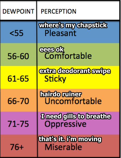
Humidity will remain unseasonably high, with dewpoints hanging around and just below 70°:
Rest of the Week: Clearing and Quiet
Skies will clear by Monday morning. For the first time in a long time, the dewpoint will stay in the low 60°s for more than 48 hours. Right on time. Fall formally starts Thursday.
Please enjoy this crap app comic strip.
We’ll still get some summer weather
Looks like high pressure to our east late in the week will send us more heat and humidity for the weekend. So stay tuned on that.
Current Radar
This website supplements @NashSevereWx on Twitter, which you can find here.
Categories: Forecast Blogs (Legacy)