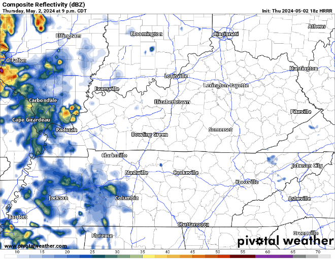
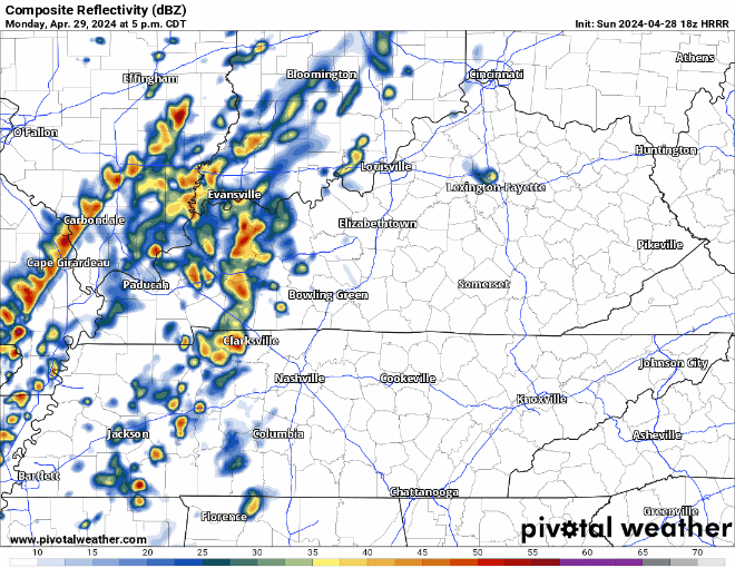
In this blog: Freezing 🧊 Fire 🔥 Rain/Storms ⛈. Deets….
Near freezing around sunrise Tue. Warming up this week.

These temps 15-17 degrees above normal. Not hot enough to break records.
Fire Weather. Meh. Worth mentioning I suppose.
In this blog: Freezing 🧊 Fire 🔥 Rain/Storms ⛈. Deets….
Near freezing around sunrise Tue. Warming up this week.

These temps 15-17 degrees above normal. Not hot enough to break records.
Fire Weather. Meh. Worth mentioning I suppose.
Temps may fall to 32° just before sunrise at BNA, but lower temps are possible in outlying areas. Last night was a good example. Got down to 36° at BNA, but we had ice on our cars this morning out where we live, with a low of 30°. So, your mileage may vary again tonight. All that to say, cover yo plants.
Showers this afternoon will clear out this evening, giving way to a precip-free first half of the week. HRRR through 10 pm:

Some chilly nights are expected tonight into Sunday morning and more so Sunday night into Monday morning. Expect scattered frost or even a light freeze either night, or both. I saw y’all at Lowe’s yesterday. Y’all who were buying flowers, tuck them in for the night. Remember, we’re not safe from freezes until about tax day around here.
Today’s blog feat. sunshine south of I-40 that won’t last.

More light, off and on rain incoming tonight and Sat morning. Latest HRRR below, time stamp upper left:

Downpours Sat AM may ruin dry-required activities. 0.75″ average rainfall, enough to waterlog most fields. However, variance will be high so your results may vary.
Showers will begin Friday morning and continue on and off until around midday Saturday. HRRR model shown below.

Heaviest rain looks like it’ll fall overnight Friday.
No severe weather concerns for us, those probabilities are to our south and west.
Fog possible tonight into Thursday morning, low beams might get some work in.
We’ll get by with a dry and warm Thursday. High temperatures get into the upper 60s.
Friday morning our rain chances return.
Some more rain tonight and early Wednesday morning.

Rain jacket or umbrella may be useful for your AM commute to school/work, but don’t think you’ll need it for the way home. A couple showers can’t be ruled out during the day tomorrow, but they’d be no big deal.
Majority of us have been able to stay dry today, and likely will remain dry thru the remainder of the day.
The same cannot be said for Tuesday, as showers are storms look likely throughout the day.

(Heads up: this gif file size is fairly large and may take a while to load)
Nice day today. Warm temperatures will continue throughout the week, but the dry conditions won’t.
Thankfully Monday will only have scattered shower chances. Majority of us will be dry most of the day.
Clouds have finally cleared out, leaving us with a nice afternoon.
Tomorrow will be even warmer, with high temperatures getting into the low 70s. Sunday looks like our last dry day for a good while.
The upcoming week will be warm but filled with rain chances.
You must be logged in to post a comment.